| |  |  | | Lake Pontchartrain Atlas: | | | | | | | | | | | | | | | | | | | | | | Physical Environments |  | | | | | | | | | | | | | | | | | | | | | | |  | | | | | | | | | | |  | Physical Environments - Hurricane History Contributors: Yamazaki, Penland 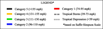 | 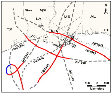 | Figure 30: Tropical Cyclones 1940 - 1949
|  | Figure 31: Tropical Cyclones 1950 - 1959
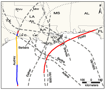
|  | Figure 32: Tropical Cyclones 1960 - 1969
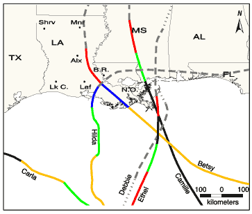
| 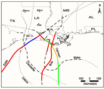 | Figure 33: Tropical Cyclones 1970 - 1979
| | Table 2: Specific Storm information (1940 - 1979) | | Storm Name | Storm Duration | Max Wind (mph) | Max Wind (km/h) | Pressure Min (mb) | Reported Landfall Date | Reported Landfall / Approach | | 08/1940 | 08/02 - 08/11/40 | 81 | 130.4 | 972 | 08/07/40 | SW Louisiana | | 09/1940 | 09/19 - 09/25/40 | 46 | 74 | * | | | | 09/1943 | 09/15 - 09/20/43 | 98 | 157.7 | * | 09/19/43 | | | 09/1944 | 09/09 - 09/11/44 | 52 | 83.7 | * | | | | 09/1945 | 09/03 - 09/06/45 | 40 | 64.4 | * | | | | 09/1947 | 09/04 - 09/21/47 | 161 | 259.1 | 947 | 09/19/47 | L. Pontchartrain, LA | | 09/1948 | 09/01 - 09/07/48 | 81 | 130.4 | 989 | 09/04/48 | Timbalier Bay, LA | | 09/1949 | 09/03 - 09/05/49 | 46 | 74 | 1008 | | | | Barbara | 07/27 - 07/30/54 | 46 | 74 | * | | | | Brenda | 07/31 - 08/03/55 | 69 | 111 | * | | | | 08/1955 | 08/23 - 08/30/55 | 46 | 74 | * | | | | 06/1956 | 06/12 - 06/15/56 | 58 | 93.3 | 1004 | | | | Flossy | 09/21 - 09/30/56 | 92 | 148 | 980 | 09/24/56 | MS Delta | | Audrey | 06/25 - 06/29/57 | 144 | 231.7 | 946 | 06/27/57 | TX/LA border | | Bertha | 08/08 - 08/11/57 | 69 | 111 | 998 | | | | Esther | 09/16 - 09/19/57 | 52 | 83.7 | 1000 | | | | Arlene | 05/28 - 06/02/59 | 58 | 93.3 | 1000 | | | | Ethel | 09/14 - 09/17/60 | 161 | 259.1 | 981 | 09/15/60 | Biloxi, MS | | Carla | 09/03 - 09/16/61 | 173 | 278.4 | 931 | 09/11/61 | Texas | | Hilda | 09/28 - 10/05/64 | 150 | 241.4 | 941 | 10/02/64 | Salt Point, LA | | Betsy | 08/27 - 09/13/65 | 155 | 249.4 | 941 | 09/09/65 | Grand Isle, LA | | Debbie | 09/24 - 09/30/65 | 52 | 83.7 | 1001 | | | | Camille | 08/14 - 08/22/69 | 200+ | 322+ | 901 | 08/17/69 | MS Delta / MS | | Edith | 09/05 - 09/18/71 | 161 | 259.1 | 943 | 09/16/71 | Pecan Island, LA | | Carmen | 08/29 - 09/10/74 | 150 | 241.4 | 928 | 09/07/74 | Point au Fer, LA | | Babe | 09/03 - 09/09/77 | 75 | 120.7 | 995 | 09/05/77 | | | Debra | 08/26 - 08/29/78 | 58 | 93.3 | 1000 | | | | Bob | 07/09 - 07/16/79 | 75 | 120.7 | 986 | 07/11/79 | Terrebonne Bay, LA | Claudette | 07/15 - 07/29/79 | 46 | 74 | 997 | | | | * = unknown | | Source: Hurricane dataset obtained from the National Hurricane Center website. « Previous | Next » |
