
Contaminated Sediments Database for the Gulf of Maine, OFR 02-403
Home/Abstract
Site Map
Introduction
Content Overview
How to Reach Us
Database Construction
How to Access
the Data
Data Utilization
Data Tables & Maps
Geographic Context
& Outside Links
References Cited
Collaborators
Acknowledgements
DISCLAIMER
EXAMPLE of Database Application
The Distribution of Lead in Gulf of Maine Sediments- Query results from the Contaminated-Sediment Database
M. Buchholtz ten Brink, E.L. Mecray, F.T. Manheim, P. Hastings, S. H. Jones, L.G. Ward, P.F. Larsen, B.W. Tripp, J.W. Farrington, G.T. Wallace, Jr., 1999. The Distribution of Lead in Gulf of Maine Sediments- Query results from the Contaminanted-Sediment Database. EOS, Transactions of the American Geophysical Union 1999 Spring meeting. Vol. 80, No. 17 Supplement, p. S187
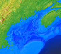
BACKGROUNDA database of contaminant measurements in sediments from the Gulf of Maine region (Fig 1) has been compiled from the literature with the collaboration and cooperation of many scientists, agencies, and institutions. The database contains 1) original data on chemical constituents 2) sample identification from existing published and gray literature sources, and 3) documentation about the quality of the data. The data set includes measurement on samples from grabs and cores that were collected from 1971-1994 and provides a tool for research and environmental management in the Gulf of Maine. Bottom sediments in the Gulf of Maine and its estuaries have accumulated pollutants of many types and from many sources, including metals and organic compounds of pesticide, industrial and petroleum derivation. Patterns of contaminant accumulation on the sea floor reflect the interaction of the 1) geologic environment (Fig 2) in which sediments are deposited, 2) the sources of contaminants (e.g., Figs 3a and 3b), and 3) the sediment and chemical transport process in situ (Fig 4). Lead (Pb) and copper (Cu) are common trace metals contaminants in coastal sediments. The database contains approximately 5000 samples for each (Fig 5). Selective queries and graphical display of the data allow identification of both regional and local trends for these contaminants in Gulf of Maine sediments. |
Fig. 1 |
|
|
A series of questions are presented with plots and maps that are created from data contained in the CONTAMINATED SEDIMENTS DATABASE FOR THE GULF OF MAINE.
|