The potentiometric surface of the Floridan aquifer system in Duval County has gradually declined primarily as a result of increased pumping. Associated with this decline in the potentiometric surface has been an increased potential for movement of saline water into the freshwater zones of the Floridan aquifer system. Gradual but continual increases in chloride concentrations in water from the aquifer system have been observed in a number of wells in Duval County. The potential for saltwater intrusion is expected to increase as population growth places greater demands on the ground-water resources of northeastern Florida.
Chloride concentrations in the Upper Floridan aquifer generally are relatively low throughout most of Duval County. The lowest concentrations occur in the southwestern part of the county, where concentrations are less than 15 milligrams per liter (mg/L). Chloride concentrations increase slightly toward the east, where concentrations typically do not exceed 30 mg/L (Spechler, 1994). Water samples collected during the drilling of monitoring wells in northeastern Florida show that, in general, water becomes more mineralized with depth; water in the Lower Floridan aquifer is more mineralized than water in the Upper Floridan aquifer, especially in the eastern part of the county. Chloride concentrations in water from the Fernandina permeable zone (deepest part of the Lower Floridan aquifer) can exceed 16,800 mg/L (Brown and others, 1986).
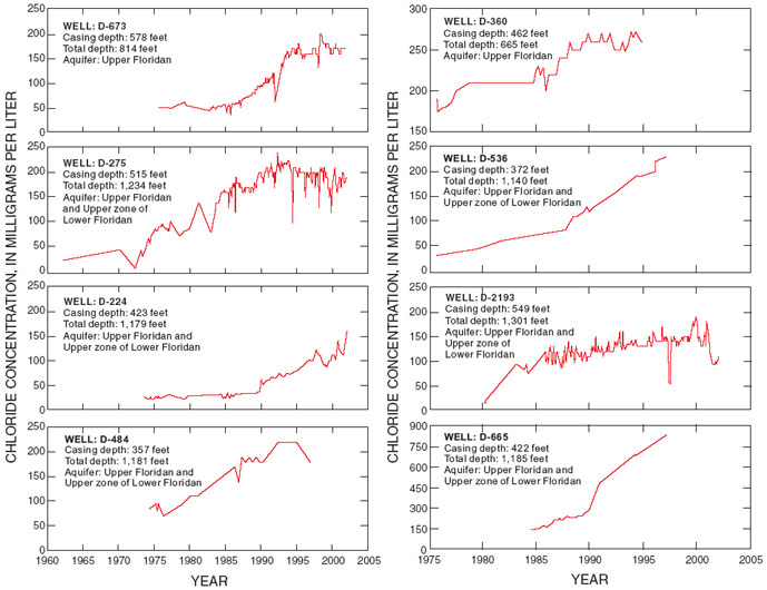
Although wells open to the Floridan aquifer system generally yield large quantities of good quality water, elevated chloride concentrations have been observed in more than 70 wells tapping the Upper Floridan and the upper zone of the Lower Floridan aquifers. Chloride concentrations exceeding 30 mg/L have been observed in some wells along the coast and up to 14 miles inland. Investigations by Spechler (1994) and Phelps and Spechler (1997) show that in a number of wells (all in eastern Duval County), chloride concentrations have increased with time. Chloride concentration trends in water from eight monitoring wells are shown in
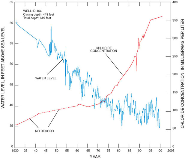
. In the western part of the county, where water in the lower part of the Floridan aquifer system probably is fresh, increased chloride concentrations in water samples from wells have not been observed. In some wells in the eastern part of the county, increases in chloride concentrations either have not been observed or are increasing at a slow rate. In a number of wells, however, chloride concentrations have increased at a steady rate. At present (2002), chloride concentrations in samples from only a few wells exceed the 250-mg/L recommended limit for drinking water; however, continued declines in water levels increase the risk of further water-quality degradation. A graph showing water-level and chloride data collected at well D-164 (1930-2000) is shown in
. Long-term data indicate that an inverse relation between water levels and chloride concentrations exists. As water levels have declined (about 24 ft in 70 years), chloride concentrations have increased from 63 to 360 mg/L.
The mechanism of saline water intrusion into the Upper Floridan aquifer, described in detail in Spechler (1994) and Phelps and Spechler (1997), most likely is not lateral intrusion of seawater from the ocean or simple regional upconing of saline water from deeper zones in the aquifer. Instead, the upward movement of saline water most likely occurs along solution-enlarged joints or fractures and collapse features, combined with horizontal movement in fractures or solutionally enhanced flow zones. Such features include paleokarst features of both relatively small, local extent and larger, regional extent. The presence of both vertical and horizontal fractures or joints and solution collapse features developed along the planes of those fractures or joints also strongly influence the movement of saline water.
Figure 11. Chloride concentrations in water from selected wells tapping the Floridan aquifer system (well location shown in figure 8). [
]
Figure 12. Water levels and chloride concentrations in water in well D-164, Fort George Island, 1930-2000. [
]