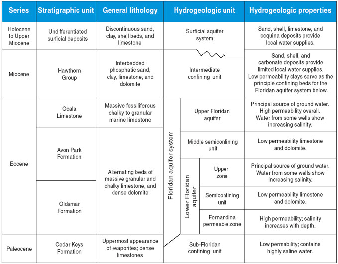
The principal water-bearing units in the study area are the surficial and the Floridan aquifer systems
. The two aquifers are separated by the intermediate confining unit, which contains beds of lower permeability sediments that confine the water in the Floridan aquifer system. In Duval County, the Floridan aquifer system is divided into the Upper Floridan aquifer and the Lower Floridan aquifer, which are separated by a zone of lower permeability. Two major water-bearing zones exist within the Lower Floridan aquifer: the upper zone of the Lower Floridan aquifer and the Fernandina permeable zone. These zones are separated by a less permeable unit that restricts the vertical movement of water.
The Floridan aquifer system underlies all of Florida and parts of Alabama, Georgia, and South Carolina. It is composed chiefly of limestone and dolomite, and includes the following stratigraphic units in descending order: the Ocala Limestone, the Avon Park Formation, the Oldsmar Formation, and the upper part of the Cedar Keys Formation
. The top of the Floridan aquifer system is defined by the top of the Ocala Limestone, and its altitude ranges from about 250 feet (ft) below sea level near Jacksonville Naval Air Station to about 600 ft below sea level in parts of central Duval County (Spechler, 1994). The surface of the Upper Floridan is a paleokarstic plain exhibiting erosional and collapse features that developed before the deposition of the overlying Hawthorn Group. Marine seismic reflection profiles show that the Continental Shelf off the coast of northeastern Florida is underlain by solution-deformed limestone of Late Cretaceous to Eocene age (Meisburger and Field, 1976; Popenoe and others, 1984; Kindinger and others, 2000). Dissolution and collapse features are scattered throughout the area. Seismic reflection investigations along the St. Johns River in northeastern Florida by Snyder and others (1989) and Spechler (1994, 1996) also revealed the presence of buried collapse and other karstic features that originated in the rocks of the Floridan aquifer system. Using land-based seismic reflection, such features also were discovered in Duval and St. Johns County (Odum and others, 1997). Two collapse features that penetrate the seafloor off the coast of St. Johns County were studied by Spechler and Wilson (1997) and Swarzenski and others (2001). Collapse features can create conduits of relatively high vertical hydraulic conductivity, providing a hydraulic connection between freshwater and deeper, more saline zones within the aquifer system.
Figure 3. General geology and hydrogeology of Duval County, Florida (modified from Spechler, 1994). [
]