|
Background
Geography
Texas, bounded on the southeast by the Gulf of Mexico and on the
west by arid and semiarid regions characteristic of the southwestern
United States, is a land of climatic and geographic diversity. The
terrain is equally diverse, ranging from the featureless coastal
plains along the Gulf Coast to the spectacular features of West
Texas, which include the Guadalupe Mountains, the canyons of Big
Bend, and the Caprock escarpment of the High Plains (fig.
1).
Sources of Moisture
The principal sources of moisture for Texas are the Gulf of Mexico
and, to a lesser extent, the eastern Pacific Ocean (fig.
1). Moisture from the Gulf of Mexico is carried into the State
by low-level southerly and southeasterly winds. Moisture from the
eastern Pacific is carried into the State from the southwest by
tropical continental air masses. In addition to the oceans, important
moisture sources include local and upwind land masses, as well as
lakes and reservoirs, from which moisture evaporates to the atmosphere.
Typically as a moisture-laden ocean air mass moves inland, it is
combined with moisture that has been recycled through the land-vegetation-air
interface.
Precipitation
The average annual precipitation differs little from north to south
but greatly from west to east. Average annual precipitation in El
Paso is less than 8 inches. More than 770 miles to the east, average
annual precipitation in the lower Sabine River valley of extreme
eastern Texas exceeds 56 inches. The precipitation varies seasonally
as well as geographically. Although spring and fall usually are
the wettest seasons, intense rainfall can occur in late summer during
the tropical storm and hurricane season. For most of the State,
however, the average precipitation during summer is only slightly
greater than that during the winter.
Spring is the wettest season in most of Texas, with April and May
often the wettest months. Spring thunderstorms generally are caused
by successive weak frontal systems that move through the State.
These cool air masses from the north meet warm, moist air masses
from the Gulf of Mexico. The warm, moist air is less dense than
the cooler air and thus overtops the cool air mass. The moist air
then condenses and forms thunderstorms along the line of contact
between the two systems. Summer usually is drier than spring in
most of the State, but a secondary peak of rainfall often occurs
in September and October. Tropical cyclones (hurricanes and tropical
storms) originate in weather systems that begin in the Caribbean
Sea or the Gulf of Mexico in late summer or early fall. Rainfall
amounts that result from tropical cyclones can differ greatly because
of the different conditions in each storm. Remnants of some hurricanes
reaching landfall have produced large depths of rainfall over wide
areas of the State.
Balcones Escarpment
The hills and associated elevation increases along the north
side of the Balcones escarpment in central Texas assist in the uplifting
of air masses and the formation of storms. Many large thunderstorms
form along the escarpment, where they can stall and produce extreme
precipitation depths during a few hours or few days. Many of the
largest storms in the State have occurred in this area. Some of
those occurring along the escarpment during about the past 80 years
are indicated in figure
2.
Largest Storms
Many Texas storms represent some of the largest storms in the world.
Figure
3 shows the largest precipitation depths in the world, for durations
ranging from 1 minute to 24 months. Also shown are some of the largest
known precipitation depths in Texas. As indicated, many of the largest
storms with durations from about 1 hour to 48 hours have occurred
in Texas. Examples of these storms include a 1921 storm in Thrall
that produced 32 inches of rainfall in 12 hours and a 1935 storm
in D'Hanis that produced 22 inches of rain in 2 hours and 45 minutes.
Flooding
Flooding from large storms has affected Texas throughout its history,
causing many deaths and much economic loss and hardship. Floods
occur regularly in Texas, and destructive floods occur somewhere
in the State every year. Many of these floods are destructive because
they often occur in areas where extreme flooding had not occurred
for many years. These floods often are perceived as unexpected or
even unprecedented because their peak water-surface elevations (stages)
can greatly exceed those of past floods. For example, a recent report
by the U.S. Geological Survey identified, for sites throughout the
State, maximum known peak stream discharges that greatly exceed
peak discharges for 100-year floods. The maximum known discharges
typically range from about 1.5 to about 3 times greater than 100-year
discharges in the western and eastern parts of the State, but documented
discharges for some sites along the Balcones escarpment have been
as much as 4 or 5 times greater than 100-year peak discharges. Such
peaks usually are devastating because structures and development
typically exist outside the 100-year floodplain but often are within
floodplains for maximum floods.
|
|
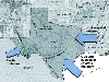
Figure 1
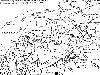
Figure 2
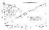
Figure 3
|
