Introduction to the
Mojave National Preserve
General Mojave
Geologic History
Changing Climates
& Ancient Lakes
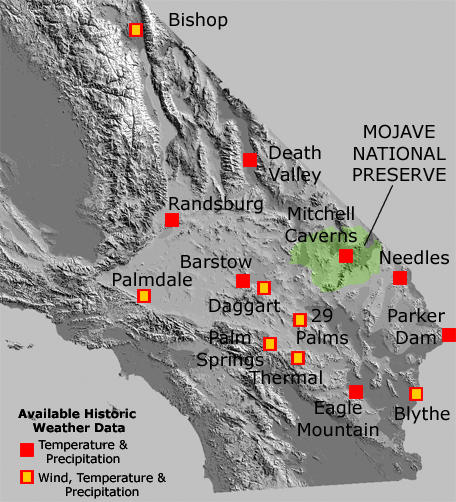
Weather Data - Selected Reporting Sites In the Greater Mojave Region
Historic weather data for the Mojave National Preserve is relatively scarce because there are no significant population centers or airports in the vicinity where records were kept. The table below provides a summary of selected sites and data from in and around the greater Mojave region that might serve as a proxy for weather conditions in different settings within the national preserve (none of the sites are within the preserve itself). In the future data from many additional weather stations in the region will be available.
The weather data basically shows what any of the regional residents could tell you. The region has very hot summers and cool winters. Most of the rain falls in the winter months, but August typically has some monsoonal storms. Spring tends to be the windiest season, and fall is the dryest and least windy season.
| Location | Barstow | Bishop | Blythe FAA |
Daggett FAA | Death Valley | Eagle Mountain | Mitchell Caverns** |
| Latitude | N34-54 | N37-22 | N33-37 | N34-52 | N36-28 | N33-48 | N34-56 |
| Longitude | W117-02 | W118-22 | W114-36 | W116-47 | W116-52 | W115-27 | W115-30 |
| Elevation | 2,162 | 4,108 | 268 | 1,922 | -194 | 973 | 4,350 |
| Temperature Degrees F |
|||||||
|
January |
60.0 31.7 45.9 |
52.9 21.4 37.2 |
67.6 38.2 52.9 |
60.7 35.9 48.3 |
65.3 39.6 52.5 |
64.1 44.1 54.1 |
54.4 36.9 -- |
|
April |
77.0 45.0 61.1 |
70.9 35.8 53.4 |
86.5 52.1 69.3 |
78.0 50.2 64.1 |
89.5 62.1 75.8 |
81.5 59.2 70.4 |
69.5 48.2 -- |
|
July |
102.6 67.2 84.2 |
97.5 56.3 77.0 |
108.7 76.8 92.8 |
104.0 73.2 88.6 |
115.4 88.4 101.9 |
105.2 82.8 94.0 |
94.0 71.1 -- |
|
October |
83.0 48.1 65.5 |
77.1 37.4 57.3 |
90.7 56.1 73.4 |
83.2 54.6 68.9 |
92.9 62.9 77.9 |
87.5 64.6 76.1 |
75.1 54.4 -- |
|
Annual |
80.3 47.7 64.0 |
74.4 37.6 56.0 |
88.1 55.4 71.8 |
81.1 53.2 67.2 |
90.4 63.0 76.7 |
84.3 62.4 74.3 |
73.0 52.3 -- |
|
Precipitation |
|||||||
| January | .66 | 1.32 | .44 | .56 | .27 | .41 | 1.54 |
| April | .22 | .31 | .17 | .27 | .14 | .14 | .53 |
| July | .31 | .19 | .11 | .32 | .16 | .41 | .90 |
| August | .30 | .11 | .94 | .50 | .09 | .56 | 1.80 |
| October | .19 | .17 | .32 | .17 | .11 | .25 | .73 |
| Annual | 4.14 | 5.61 | 3.75 | 3.81 | 2.03 | 3.26 | 11.82 |
|
Wind Speed |
|||||||
| January | 7.1 | 6.5 | 8.6 | ||||
| April | 10.1 | 8.9 | 13.8 | ||||
| July | 8.3 | 9.4 | 12.2 | ||||
| August | 8.4 | 8.8 | 11.4 | ||||
| October | 8.1 | 6.7 | 9.5 | ||||
| Annual | 8.4 | 7.8 | 10.9 |
| Location | Needles FAA | Palm Springs |
Palmdale |
Parker Reservoir | Randsburg | Thermal FAA |
Twentynine Palms |
| Latitude | N34-46 | N33-49 | N34-35 | N34-17 | N35-22 | N33-38 | N34-08 |
| Longitude | W114-37 | W116-32 | W118-06 | W114-10 | W117-39 | W116-10 | W116-02 |
| Elevation | 913 | 411 | 2,596 | 738 | 3,570 | 120 | 1,975 |
| Temperature Degrees F |
|||||||
|
January |
62.9 40.9 51.9 |
69.3 40.8 55.1 |
58.6 32.2 45.4 |
63.9 42.4 53.2 |
53.8 35.7 44.7 |
69.8 38.3 54.1 |
62.7 35.3 49.0 |
|
April |
83.4 56.3 69.9 |
86.2 52.2 69.2 |
72.9 42.6 57.8 |
83.3 58.7 71.1 |
71.0 45.6 58.4 |
85.6 55.1 70.4 |
81.0 48.5 64.7 |
|
July |
108.7 83.1 95.9 |
109.1 74.1 91.7 |
97.7 65.0 8.14 |
107.8 83.4 95.6 |
98.8 68.7 83.8 |
106.9 76.9 91.9 |
105.4 72.1 88.7 |
|
October |
87.9 61.1 74.7 |
92.1 57.9 75.0 |
80.6 47.4 64.0 |
89.5 64.4 77.0 |
77.1 53.2 65.2 |
91.0 57.8 74.4 |
86.0 52.7 69.6 |
|
Annual |
85.5 60.1 72.8 |
88.8 55.8 72.3 |
77.1 46.4 61.6 |
85.5 61.9 73.9 |
74.9 50.4 62.7 |
88.1 56.7 72.4 |
83.5 51.8 67.7 |
|
Precipitation |
|||||||
| January | .52 | 1.26 | 1.73 | .78 | 1.23 | .52 | .42 |
| April | .26 | .17 | .53 | .23 | .40 | .07 | .12 |
| July | .47 | .04 | .04 | .31 | .12 | .18 | .67 |
| August | .67 | .06 | .23 | .60 | .16 | .30 | .68 |
| October | .35 | .65 | .16 | .46 | .20 | .14 | .26 |
| Annual | 4.39 | 5.20 | 7.38 | 4.97 | 5.48 | 2.82 | 3.89 |
|
Wind Speed |
|||||||
| January | 6.6 | 8.8 | 5.0 | 6.1 | |||
| April | 10.3 | 12.9 | 8.3 | 9.9 | |||
| July | 9.7 | 12.0 | 7.0 | 8.1 | |||
| August | 8.9 | 10.8 | 6.2 | 7.5 | |||
| October | 8.0 | 9.2 | 5.9 | 6.0 | |||
| Annual | 8.7 | 10.6 | 6.5 | 7.6 |
Temperature and precipitation data from: NOAA, National Climatic
Center (re-compiled by Gale Research Company, 1983, Climate Normals
for the U.S. [Base: 1951-1980]: Detroit, MI.) **Mitchell Caverns,
CA data reported from 1971 to 2000 from: http://www.ohwy.com/ca/w/wx045721.htm.
Wind data from: http://www.wrcc.dri.edu/htmlfiles/westwind.final.html
- Western Regional Climate Center (Desert Research Institute and others;
Reno, NV): The monthly average wind speeds are based on hourly observations
from reporting airports and based on data from 1992-2002.

