|
|
 |
GIS Data Layers
Data in this publication are intended to be integrated into a Geographic Information System (GIS). A GIS is defined as a system of hardware and software to support the display, manipulation, and analysis of spatial data for mapping and complex data analysis. This integrated package provides researchers the ability to integrate, analyze and map the various datasets to help with economic and social policy-making decisions regarding the environment.
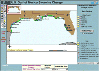
Individual data layers for this publication along with additional basemap layers have been compiled into an Internet Map Server. The Coastal and Marine Geology Internet Map Server brings the usefulness of a GIS into your computer via a web browser. For an introduction to the Internet Map Server, see the Coastal and Marine Geology Program Internet Map Server Introduction and Help Web page.
There are nine GIS data layers offered for each state in the Gulf of Mexico. These include: four vector shorelines, an offshore baseline used for generating shore-normal transects, transects for long- and short- term shoreline change rates, transect/shoreline intersection positions, and a vector layer to show the spatial extents of beach nourishment projects. The GIS data layers from this publication are cataloged below by state for easy access.
Federal Geographic Data Committee (FGDC) compliant metadata for the individual data layers is provided in three versions (HTML, FAQ, text). Selecting associated metadata files from the table below will open the information in a new browser window.
A 'zip' compressed, downloadable archive file containing the components of the ArcView shapefile for each data layer is also provided. Compressed downloadable files were created using the Windows program WINZIP v8.1. For those users who do not have software capable of uncompressing the archived zip files, they may obtain a free version of the software from Winzip Computing, Inc.
| Data Layers by State |
| Florida |
| Layer Name - Description |
Metadata |
Files |
| fl1855_1895 - Vector shoreline derived from 1855-1895 source data |
HTML, FAQ, text |
fl_zip
(22.5 MB) |
| fl1926_1953 - Vector shoreline derived from 1926-1953 source data |
HTML, FAQ, text |
| fl1976_1979 - Vector shoreline derived from 1976-1979 source data |
HTML, FAQ, text |
| fl1998_2001 - Vector shoreline derived from 1998-2001 source data |
HTML, FAQ, text |
| fl_baseline - Offshore baseline for generating shore-normal transects |
HTML, FAQ, text |
| fl_transects_lt - Shore-normal transects with associated long-term rates of shoreline change |
HTML, FAQ, text |
| fl_transects_st - Shore-normal transects with associated short-term rates of shoreline change |
HTML, FAQ, text |
| fl_intersects - Transect/Shoreline intersection positions |
HTML, FAQ, text |
| fl_nourish - Alongshore vector showing spatial extents of beach nourishments |
HTML, FAQ, text |
| Alabama |
| Layer Name - Description |
Metadata |
Files |
| al1849_1867 - Vector shoreline derived from 1849-1867 source data |
HTML, FAQ, text |
al_zip
(872 KB) |
| al1918_1957 - Vector shoreline derived from 1918-1957 source data |
HTML, FAQ, text |
| al1978_1981 - Vector shoreline derived from 1978-1981 source data |
HTML, FAQ, text |
| al2001 - Vector shoreline derived from 2001 source data |
HTML, FAQ, text |
| al_baseline - Offshore baseline for generating shore-normal transects |
HTML, FAQ, text |
| al_transects_lt - Shore-normal transects with associated long-term rates of shoreline change |
HTML, FAQ, text |
| al_transects_st - Shore-normal transects with associated short-term rates of shoreline change |
HTML, FAQ, text |
| al_intersects - Transect/Shoreline intersection positions |
HTML, FAQ, text |
| al_nourish - Alongshore vector showing spatial extents of beach nourishments |
HTML, FAQ, text |
| Mississippi |
| Layer Name - Description |
Metadata |
Files |
| ms1850 - Vector shoreline derived from 1850 source data |
HTML, FAQ, text |
ms_zip
(649 KB) |
| ms1917 - Vector shoreline derived from 1917 source data |
HTML, FAQ, text |
| ms1986_1987 - Vector shoreline derived from 1986-1987 source data |
HTML, FAQ, text |
| ms2001 - Vector shoreline derived from 2001 source data |
HTML, FAQ, text |
| ms_baseline - Offshore baseline for generating shore-normal transects |
HTML, FAQ, text |
| ms_transects_lt - Shore-normal transects with associated long-term rates of shoreline change |
HTML, FAQ, text |
| ms_transects_st - Shore-normal transects with associated short-term rates of shoreline change |
HTML, FAQ, text |
| ms_intersects - Transect/Shoreline intersection positions |
HTML, FAQ, text |
| Louisiana |
| Layer Name - Description |
Metadata |
Files |
| la1855_1887 - Vector shoreline derived from 1855-1887 source data |
HTML, FAQ, text |
la_zip
(2.6 MB) |
| la1922_1934 - Vector shoreline derived from 1922-1934 source data |
HTML, FAQ, text |
| la1973_1978 - Vector shoreline derived from 1973-1978 source data |
HTML, FAQ, text |
| la2001 - Vector shoreline derived from 2001 source data |
HTML, FAQ, text |
| la_baseline - Offshore baseline for generating shore-normal transects |
HTML, FAQ, text |
| la_transects_lt - Shore-normal transects with associated long-term rates of shoreline change |
HTML, FAQ, text |
| la_transects_st - Shore-normal transects with associated short-term rates of shoreline change |
HTML, FAQ, text |
| la_intersects - Transect/Shoreline intersection positions |
HTML, FAQ, text |
| la_nourish - Alongshore vector showing spatial extents of beach nourishments |
HTML, FAQ, text |
| Texas |
| Layer Name - Description |
Metadata |
Files |
| tx1850_1883 - Vector shoreline derived from 1850-1883 source data |
HTML, FAQ, text |
tx_zip
(4.6 MB) |
| tx1930_1938 - Vector shoreline derived from 1930-1938 source data |
HTML, FAQ, text |
| tx1970_1975 - Vector shoreline derived from 1970-1975 source data |
HTML, FAQ, text |
| tx2000_2001 - Vector shoreline derived from 2000-2001 source data |
HTML, FAQ, text |
| tx_baseline - Offshore baseline for generating shore-normal transects |
HTML, FAQ, text |
| tx_transects_lt - Shore-normal transects with associated long-term rates of shoreline change |
HTML, FAQ, text |
| tx_transects_st - Shore-normal transects with associated short-term rates of shoreline change |
HTML, FAQ, text |
| tx_intersects - Transect/Shoreline intersection positions |
HTML, FAQ, text |
| tx_nourish - Alongshore vector showing spatial extents of beach nourishments |
HTML, FAQ, text |
|
| Base Layers |
| Layer Name - Description |
Metadata |
Files |
| NOS80k - Medium resolution digital vector U.S. shoreline. Type: feature - polygon. |
HTML, FAQ, text |
zip
(26 MB) |
| state_bounds - Internal U.S. state boundaries |
HTML, FAQ, text |
zip
(1.8 MB) |
| cities - Cities and towns of the United States |
HTML, FAQ, text |
zip
(1.3 MB) |
|
continue to References
|