Data Set and Methods
Choosing Tide Stations
Open Coast Tide Stations
There are approximately 1000 East Coast, 400 West Coast, and 250 Gulf Coast tide station bench mark sheets on the CO-OPS Web site. The tide stations (many of which are not currently in operation) are located in a variety of environments, including rivers, bays, inlets, harbors, and open coast environments. We decided that only open coast tide stations would be used to establish the operational MHW elevations that will be used for deriving open coast shorelines from lidar data.
There were several steps involved in determining which stations were located on the open coast. The tidal bench mark sheets are organized by state, and each state's bench mark list is made up of the names and identification numbers of its tide stations. Many of the station names include that station's location such as a river, bay, creek, harbor, fishing pier, ocean, etc. (Appendix I) (PDF Format). Each state's bench mark list was viewed, and notes were taken on station locations. Any station that was listed as being on the Atlantic or Pacific Oceans or the Gulf of Mexico was automatically considered an open coast station. Stations that were listed as being on a beach or fishing pier, and stations whose locations were not clear from their names were considered potential open coast tide stations.
In order to determine whether the potentially open coast stations were actually located on an open coast, the locations (latitude and longitude) of these stations were plotted on the NOAA/NOS Medium Resolution Digital Vector Shoreline (average scale of approximately 1:70,000). These shoreline data were obtained from the National Geophysical Data Center's "Coastline Extractor" Web site located at http://rimmer.ngdc.noaa.gov/coast/getcoast.html/. Once the stations were plotted on the coastline, the figures were zoomed-in until it was clear if tidal flows were restricted at each station. Stations with a free connection to the open ocean tide were considered to be on the open coast.
In order to use the MHW, MHHW, and MTL data from any open coast tide station, the tidal datums or bench mark heights had to be referenced to a fixed vertical datum such as the National Geodetic Vertical Datum of 1929 (NGVD 29) or NAVD 88. There were many open coast tide stations whose data were neither referenced to NGVD 29 nor NAVD 88 and could therefore not be used for this project. These included: Cape Neddick, Atlantic Ocean, Maine; Shinnecock Inlet, Atlantic Ocean, New York; Wildwood Crest, Atlantic Ocean, NJ; Cape Lookout, Atlantic Ocean, North Carolina; Ocean City Beach, Atlantic Ocean, North Carolina; Garden Key, Dry Tortugas, Gulf of Mexico, Florida; Panther Key, Gulf of Mexico, Florida; Anclote Lighthouse, Anclote Key, Gulf of Mexico, Florida; Moss Landing Ocean Pier, Pacific Ocean, CA; and Balboa Pier, Newport Beach, Pacific Ocean, CA. However, MHW with respect to NAVD 88 was calculated at Cape Neddick, Maine, and Shinnecock Inlet, New York, because the elevation of MTL above NAVD 88 along the New England and New York coasts is nearly constant. (See the section "Calculating MHW, MHHW, and MTL: Mean Tide Level Method" for more details). There was also one open coast tide station (Raccoon Point, Gulf of Mexico, Florida) whose MHW, MHHW, and MTL elevations could not be determined because the available bench mark data were not accurate enough (i. e., the height of the one bench mark at this site was listed as 1.0 m, but 3.0 ft, above NAVD 88).
Sixty-five open coast tide stations with data referenced to either NGVD 29 or NAVD 88 were accepted: 36 along the East Coast, 18 on the Gulf Coast, and 11 on the West Coast. However, there were still several sections of coast for which no open coast tide data were available. These sections included New England, New York, Georgia, Louisiana, Mississippi, Alabama, Washington, and parts of Florida, Oregon, Texas, and California. We decided that additional tide stations (ones that were not fully on the open coast) would need to be used to fill these gaps so that elevations for MHW, MHHW, and MTL could be obtained for the entire East, Gulf, and West Coasts. Near-open Coast Tide Stations
The tidal bench mark lists were viewed again and station locations were plotted to find stations to fill the gaps. Stations that were closest to the open coast were chosen, and only enough stations were chosen to fill the gaps. That is, if there were several near-open coast stations in a short length of coastline, only one of those stations was chosen to fill that space. These additional stations were in the mouths of bays or inlets, or were in harbors, but were the best stations that could be found in the necessary locations. Eleven stations were added to the East Coast: seven in New England, one in New York, one in Georgia, and two in Florida. Six stations were added to the Gulf Coast: one in Texas, one in Louisiana, one in Mississippi, one in Alabama, and two in Florida. Eight stations were added to the West Coast: three in Washington, one in Oregon, and four in California.
Additional Tide Stations in New England and New York
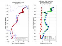 |
| Figure 2. East Coast tide station locations and their tidal datum elevations. Click on figure for larger image. |
The nine open and near-open coast tide stations that were chosen in New England and New York were insufficient for determining MHW elevations at the level of detail necessary for the National Assessment Project because the tide range in this area is extremely variable. Furthermore, no usable stations were found along the southern shore of Long Island, New York, along the section of the Connecticut coast for which lidar shorelines will be derived, or along the outer coast of Cape Cod, Massachusetts. However, MTL above NAVD 88 is nearly constant along the coasts of New England and New York (see Figure 2, which is explained in detail in the Results section of the report). By assuming a constant MTL, the elevations of MHW and MHHW above
NAVD 88 can be calculated (see "Mean Tide Level Method," below).
Bench mark sheets for 11 additional stations whose tidal datums and bench marks were not referenced to a fixed vertical datum were selected for this area. These included: five stations in Maine, one in Massachusetts, four in Rhode Island, and one in New York. Additionally, CO-OPS provides predicted tide data at more than 3000 locations (over 500 of which are located in New England and New York) on their Web site at http://co-ops.nos.noaa.gov/tide_pred.html. The sites with predicted tide data are organized by state and region, and the location (latitude and longitude), mean tide range, spring range, and MTL are listed for each site. Links to the predicted tide data are also listed for each location (Appendix III) (PDF Format).
The lists of locations in New England and New York for which 2003 predicted tide data were available were viewed, and sites that were described as being in areas covered by the National Assessment Project were plotted on the NOAA/NOS Medium Resolution Digital Vector Shoreline. The figures were zoomed-in, and all open coast and near-open coast locations were selected. Thirty-five sites were selected for New England and New York. These 35 locations from the tidal prediction pages (which will be referred to as "stations" throughout the remainder of this report), along with the 11 tide stations with bench mark sheets whose tidal datums and bench marks were not referenced to a fixed vertical datum, plus the original nine stations whose tidal datums or bench marks were referenced to either NGVD 29 or NAVD 88, were sufficient for determining MHW elevations along the coasts of New England and New York at the level of detail necessary for the National Assessment Project. In all, 93 East Coast, 19 West Coast, and 24 Gulf Coast stations were chosen for a total of 136 tide stations.
|

