Geologic Variables
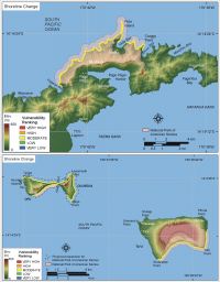
The geomorphology variable expresses the relative erodibility of different landform types (Table 1). These data were derived using habitat maps provided by the Pacific Islands GIS Project and NOAA/NOS (http://www.csc.noaa.gov/islandsgis/resources.html). For Tutuila a coastal resource inventory report was used to help differentiate geomorphology types (Richmond, 1995). In addition, during the fieldwork portion of this research an aerial overflight was conducted within the park and oblique aerial photos of the coast were obtained (Figure 4, Figure 5, and Figure 6). The National Park of American Samoa consists of several geomorphology types, including very high vulnerability carbonate sand beaches, high vulnerability rubble to rocky shoreline skirted by fringing reef, moderate vulnerability alluvium and narrow fringing reef with cliffs, and low and very low vulnerability rock cliffs (Figure 7).
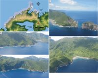 |
| Figure 4. Photographs of geomorphologic features on Tutuila in the National Park of American Samoa.Click on figure for larger image. |
| 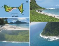 |
| Figure 5. Photographs of geomorphologic features on Ofu and Olosega in National Park of American Samoa.Click on figure for larger image. |
| 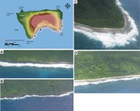 |
| Figure 6. Photographs of geomorphologic features on Ta'u in National Park of American Samoa.Click on figure for larger image. |
|
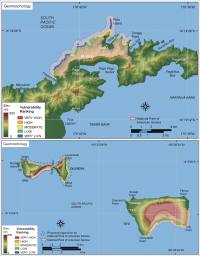 |
| Figure 7. Vulnerability ranking for coastal geomorphology within the National Park of American Samoa. Click on figure for larger image. |
|  |
| Figure 8. Vulnerability ranking for shoreline change rates for the National Park of American Samoa. Click on figure for larger image. |
|  |
| Figure 9. Vulnerability ranking for regional coastal slope of the National Park of American Samoa. Click on figure for larger image. |
|
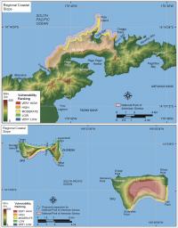
Shoreline erosion and accretion rates for the National Park of American Samoa were estimated using oblique aerial photos. Historical digital vector shorelines are used to calculate a rate of shoreline change where historic shoreline information is available. These data were not available for American Samoa, so the oblique aerial photos collected for geomorphologic determination were used to qualitatively estimate what areas within in the park might be experiencing high erosion/accretion rates. The oblique aerial photos provided no geoindicators (dune scarps, trees at the water line, etc. for more information on geoindicators see: http://www.lgt.lt/geoin/) for shoreline change rates greater that +/- 1 m/yr, therefore, shoreline change rates within the park were all classified as moderate vulnerability, between -1 m/yr and +1 m/yr (Figure 8).
The determination of regional coastal slope is an indication of the relative vulnerability to inundation and the potential rapidity of shoreline retreat because low-sloping coastal regions should retreat faster than steeper regions (Pilkey and Davis, 1987). The regional slope of the coastal zone was calculated from a grid of topographic and bathymetric elevations extending 2 km landward and seaward of the shoreline. Elevation data were obtained from the National Geophysical Data Center (NGDC) as gridded topographic and bathymetric elevations at 0.1-meter vertical resolution for 1-minute grid cells. This data was supplemented using DEM data from NOAA's Biogeography Program (Table 2). Regional coastal slopes for National Park of American Samoa fall within the low to high vulnerability category (4.6% - 14.7%) (Figure 9).
Back to Top

 [an error occurred while processing this directive]