|
|
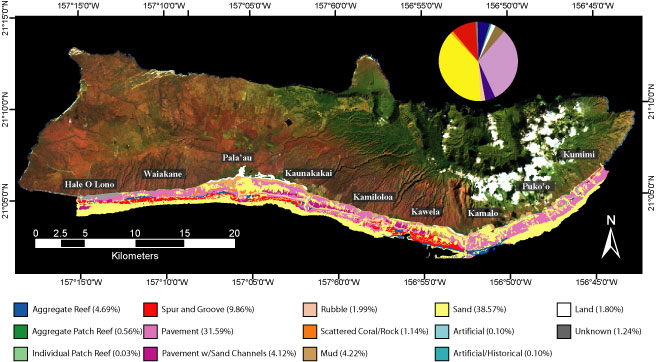
| U.S. Geological Survey Open File Report 2005-1070 Version 1.0 Moloka'i Benthic Habitat MappingResultsDominant Structure/SubstrateThe South Moloka'i reef was classified into 14 different structures, or substrates, that delineate the reef morphology. Nearly 66 km2 (54% of the total area mapped) consists of combined reef and hardbottom substrates; softbottom sand and mud comprise just over 52 km2 (43%), as shown in Figure 5.
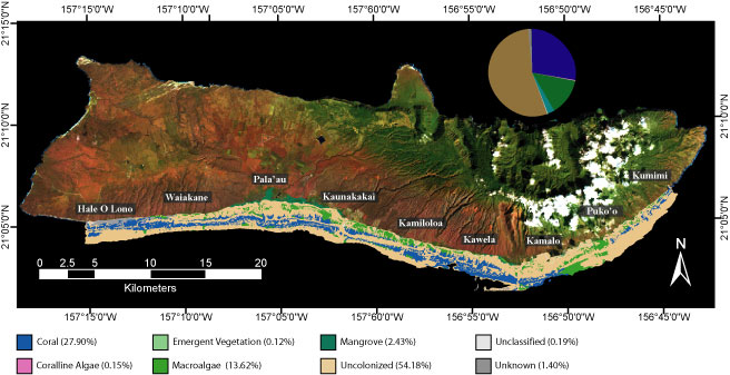
Figure 5. Landsat satellite image overlaid with the benthic habitat classification map of Moloka'i showing the Dominant Structure/Substrate layer and the percentage of each class. A major feature of the South Moloka'i reef is the broad, shallow pavement platform of the reef flat, which extends nearly 1.5 km offshore in the Pala'au and Kaunakakai areas. A mud veneer and ancient fishponds lie close to shore, while sand patches and coral-covered pavement dominate the seaward edge of the reef flat. Seaward of the reef crest, the fore reef alternates between abundant reef and barren hard pavement. The fore reef follows a spur and groove morphology pattern, which is especially pronounced in the west. Aggregate reef growth is predominantly observed in the Pala'au and Kamalo regions. The areas off Kamiloloa and Puko'o, however, are barren "dead zones" of hard pavement with little or no active reef development. The base of the fore reef is around a depth of 27 m (90 ft), where it transitions into a gently sloping sand-covered plain of the shelf zone. Reef development pinches out near the ends of the island where high wave energy likely limits growth (Storlazzi et al., 2003). Major Biological CoverThe 14 different structures/substrates are covered with 8 different biological habitat classes. Coral covers 51% of the suitable hard substrate on the South Moloka'i reef (over 34 km2 or 28% of the overall study area), as shown in Figure 6.
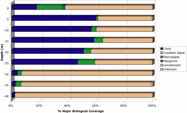
Figure 6. Landsat satellite image overlaid with the benthic habitat classification map of Moloka'i showing the Major Biological Cover layer and the percentage of each class. Coral cover varies geographically. The highest percentages are found offshore of the Pala'au and Kamalo areas. Studies have shown Pala'au and Kamalo to have the highest coral coverage in the main Hawaiian Islands (Jokiel et al, 2001). Offshore of Kamiloloa and Puko'o are large "dead zones" where the hard pavement is barren or covered with macroalgae (e.g. Halimeda sp.). The coral-covered pavement at the seaward edge of the reef flat is dominated by Porites lobata colonies. These shallow colonies appear as knobby flat-topped mesas, with live tissue on the sides of the coral mounds. Surface exposure, wave influences, and/or present sea-level prevent vertical growth of these coral mounds. These flat-topped coral mounds can be exposed at low tides, making it difficult for live coral tissue to grow. The irregular surface of the knobby mounds sometimes has macroalgae or coralline algae growing on it, and may contain sediment in the depressions, or "pukas". Aggregate reefs and spur and groove formations on the fore reef are dominated mostly by Porites sp. and Montipora sp. Large patches of the macroalgae, Halimeda sp. may be found in the sand at the base of the forereef around 27 m (85 ft) depth. These calcareous algae are likely a major contributor to the sand supply on the island's shelf. The highest percentages of coral are found between depths of 5 m and 15 m (between 15 ft and 50 ft) across the entire reef (Figure 7). However, abundant coral is also found between depths of 20 m and 25 m (between 65 ft and 85 ft) in some localized areas.
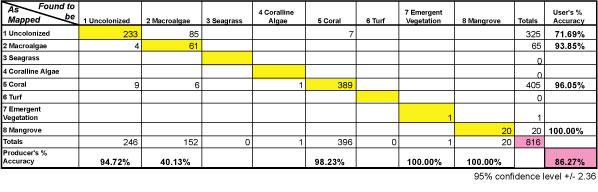
Figure 7. Graph showing the variability of the percent Major Biological Cover with depth. Accuracy AssessmentFigure 8 shows the matrix of accuracy assessment calculations for the Major Biological Covers. A total of 816 points were checked in the field. The overall accuracy of 86.27% (with a 95% confidence interval of ± 2.36) indicates which points on the map were classified correctly according to the field check. A Tau coefficient of 0.9845 (with a 95% confidence interval of ± 0.85) indicates that 98% more points were classified correctly than would be expected by chance alone. The greatest amount of error was found in the Uncolonized class (Producer's Accuracy = 40.13%; User's Accuracy = 71.69%). In this instance, what we mapped as uncolonized sand on the forereef at depths of approximately 27 m (90 ft) many times was found to be sand with >10% macroalgae (Halimeda sp.), which was too sparse to be resolved on the SHOALS data.
Figure 8. Matrix showing the accuracy assessment calculations. After accuracy assessment calculations were performed, any misinterpreted polygons on the South Moloka'i reef map(s) were corrected using the field check data, thus increasing the accuracy of the final map to greater than 86.27%. Next section: Summary |
URL of this page: http://pubs.usgs.gov/of/2005/1070/
Date created: 18 February 2005
Created by: Susan A. Cochran
Maintained by: Susan A. Cochran
Date last modified: 5 July 2007 (sac)
USGS Privacy Statement | Disclaimer | Feedback | Accessibility
Department of the Interior | US Geological Survey | Biology | Geology | Mapping | Water