The Glacier Bay National Park and Preserve
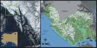
Glacier Bay National Park and Preserve lies along the southeastern coast of Alaska within a geologic area known as the Alexander Archipelago (fig. 2). The Alexander terrane was made up of Paleozoic ocean trench sediments, volcanic rocks, limestones, and cherts when it welded to North America during the mid-Jurassic.
Since that time the Alexander terrane has experienced igneous intrusions, broad metamorphosis with recrystallization, and large-scale faulting (as much as 200 km),
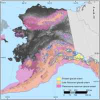
which has resulted in a very complex geologic framework for southeast Alaska (Connor and O'Haire, 1988). In addition to the tectonic activity associated with accreting terranes, the advance and retreat of glacier ice throughout the Pleistocene (fig. 3) has caused drastic sea-level fluctuations along the coast of the Gulf of Alaska due to isostasy. Alpine glaciers may have appeared in the mountains of southern Alaska between 10 and 13 million years ago and many of these areas have remained ice covered for at least the past five million years (Connor and O'Haire, 1988). Deep valleys carved by glaciers during glacial maxima are now flooded, creating irregular shorelines such as the arms of Glacier Bay. Glacier Bay itself was completely filled with ice during the Little Ice Age (1400 - 1750 AD), and as the glaciers began to retreat up the bay a large outwash plain was deposited where the town of Gustavus is now located. Today GBNPP has 11 tidewater glaciers that are supplying ice and sediment directly to the coast where waves and tides further modify this rugged coastline creating a variety of geomorphology types including sand, gravel, and boulder beaches, rock cliffs and platforms, mud flats, and modified alluvial and glacial deposits.
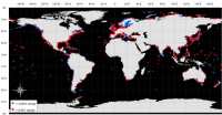
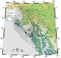
An aspect that makes Glacier Bay and most of southeastern Alaska unique when compared to the majority of the world's coastline is that this region is experiencing a fall in relative sea-level due to uplift of the land through glacial rebound and isostatic adjustments (fig. 1). Essentially, the area is emerging at a faster rate than global sea-level (1.8 mm/yr) is rising. Parts of Glacier Bay are experiencing some of the highest rates of uplift (28 mm/yr) in southeastern Alaska (fig. 4). Uplift rates are determined from raised shorelines, GPS measurements, water level recorders, and ice load and viscoelastic earth models (Larsen and others, 2003; Larsen and others, 2005).