Skip past header information
USGS Logo with link to USGS Web page

Coastal Vulnerability Assessment of Kaloko-Honokohau National Historical Park to Sea-Level Rise
USGS Open-File Report 2005-1248

Map of Coastal Vulnerability

Skip past contents informationTable of Contents Link to Kaho Page Link to Title Page Link to Abstract Page Link to Introduction Page Link to Data Ranking System Link to Kaho Page Link to Methodology Page Link to Geologic Variables Link to Physical Process Variables Link to Calculating the Vulnerability Index Link to Results Link to Discussion Link to Conclusions Link to References

Discussion

Kaloko-Honokohau NHP is a small park; therefore most of the variables that determine the coastal vulnerability index vary little within the park boundary. The value of the relative sea-level rise variable is constant at very high vulnerability for the entire study area. The tidal range is very high vulnerability (< 1 m) for all of Kaloko-Honokohau NHP. Vulnerability assessment based on shoreline change is moderate vulnerability. Regional coastal slope is very low for all of Kaloko-Honokohau NHP.

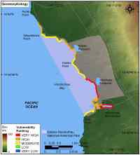
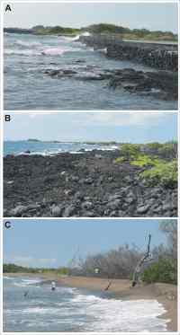
Mean significant wave height (very low to high vulnerability) and geomorphology are the only variables that vary spatially within the park. Geomorphology includes very high vulnerability sandy beach shoreline, high vulnerability coral rubble and rock and sand beaches, and moderate vulnerability rock shoreline with storm deposits (fig. 3 and fig. 4 A-C).

The most influential variables in the CVI are geomorphology and mean significant wave height; therefore they may be considered the dominant factors controlling how this park will evolve as sea level rises. The methodology for this coastal vulnerability assessment is best suited for parks larger than Kaloko-Honokohau NHP, however the results presented here are useful for park planning purposes in conjunction with higher resolution studies.

Figure 3. Coastal Geomorphology for Kaloko-Honokohau National Historical Park.

Figure 4. Photos of different geomorphologic settings within Kaloko-Honokohau National Historical Park.

Back to Top


Skip Footer Information

Accessibility FOIA Privacy Policies and Notices


Take Pride in America home page. FirstGov button U.S. Department of the Interior | U.S. Geological Survey
URL: http://pubsdata.usgs.gov/pubs/of/2005/1248/html/discussion.htm
Page Contact Information: Publication Services
Page Last Modified: 22:06:49 Sat 12 Jan 2013