U.S. Geological Survey Open-File Report 2006-1210
Final Report and Archive of the Swath Bathymetry and Ancillary Data Collected in the Puerto Rico Trench Region in 2002 and 2003 .
|
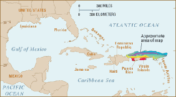
Three exploration cruises of the U.S. Geological Survey (USGS) and the National Oceanic and Atmospheric Administration (NOAA) (USGS cruise 02051, NOAA cruise RB0208, September 24 to 30, 2002; USGS cruise 03008, NOAA cruise RB0303, February 18 to March 7, 2003; and USGS cruise 03032, NOAA cruise RB0305, August 28 to September 4, 2003) carried out in the Puerto Rico Trench region within a 2-year period have mapped for the first time the morphology of the tectonic plate boundary stretching from the Dominican Republic in the west to the Lesser Antilles in the east, a distance of approximately 700 kilometers (km) (430 miles; fig. 1). The Puerto Rico Trench, with water depths of 8,400 meters (m), is the deepest place in the Atlantic Ocean. Its depth is comparable to the deep trenches in the Pacific Ocean. Trenches in the Pacific are located in places where one tectonic plate subducts or slides under another one. The Puerto Rico trench, in contrast, is located at a boundary between two plates that slide past each other with only a small component of subduction. The trench is less deep near the Lesser Antilles, where the component of subduction is larger. The unusually deep seafloor is not limited to the trench, but it also extends farther south toward Puerto Rico. The Puerto Rico trench is also associated with the most negative free-air gravity anomaly on earth, -380 mGal , which indicates the presence of an active downward force. Many earthquakes and tsunamis that result from these plate tectonic movements have occurred throughout history in the northeastern Caribbean. As the population in this region continues to grow, future such events are likely to pose a serious hazard to the 4 million U.S. citizens of Puerto Rico and the Virgin Islands. The hazards to these islands are mainly in the form of submarine faults and slides. Observations from the three exploration cruises, coupled with computer modeling and with published Global Positioning System (GPS) results and earthquake focal mechanisms, have provided new information that is changing the evaluation of the seismic and tsunami hazard from this plate boundary. Whereas the seismic hazard appears to be less severe than was previously estimated from generic models, tsunami hazards may be more severe than previously thought. Continuous retrograde slumping through time, the observation of large cracks on the slope north of Puerto Rico, and the discovery of giant landslides on the downtrending North American plate highlight the potential for future submarine slides. The observations collected during these cruises also contributed to the basic understanding of the mechanisms that govern plate tectonics, in this case, the creation of the island of Puerto Rico and the deep trench north of it. All three cruises were carried out aboard the NOAA ship Ronald H. Brown. An area the size of the State of Maine was mapped during 21 survey days using the SeaBeam 2112 multibeam system, which was mounted on the keel of the Ronald H. Brown. These cruises also served to test and improve the performance of the system for future use by NOAA. The last cruise took place between August 28 and September 4, 2003. The seafloor multibeam data from the three cruises were merged to create a uniform morphology database for Puerto Rico and its surrounding seas at a grid interval of 150 m. Participants on the last cruise included Uri ten Brink (chief Scientist), William Danforth, and Christopher Polloni from the USGS Woods Hole Coastal and Marine Science Center; Kenneth Kiesel from L-3 Klein Associates, Inc.; Kenneth Nadeau from the Woods Hole Labortory of NOAA National Marine Fisheries Service’s Northeast Fisheries Science Center; Koura Gibson, NOAA teacher at sea; Joram ten Brink, Westminster University; and Eran Kaplan, Tel Aviv University.
|