Open-File Report 2006-1381
![]() Title |
Figures |
1-Introduction |
2-Data Collection and Processing |
3- Geologic Interpretation |
4-References |
5-Maps |
Spatial Data |
Acknowledgments
Title |
Figures |
1-Introduction |
2-Data Collection and Processing |
3- Geologic Interpretation |
4-References |
5-Maps |
Spatial Data |
Acknowledgments
 |
||
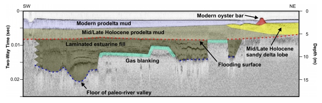
Figure 11. Interpreted seismic profile showing the stratigraphic intervals underlying Apalachicola Bay. The deepest horizon imaged is the floor of a Pleistocene river valley. This valley was filled during the Early and Middle Holocene by estuarine deposits. During the Late Holocene, a delta system advanced into the bay. Presently mud derived form the Apalachicola River blankets large parts of these older stratigraphic intervals. Vertical scales for the seismic profile are provided in milliseconds (two-way travel time) and approximate depth in meters (assuming a seismic velocity of 1500 m/s). The location of profile 11 is identified on seismic profile A of figure 12 and also in figure 13. | ||

![]() U.S. Department of the Interior |
U.S. Geological Survey
U.S. Department of the Interior |
U.S. Geological Survey
URL: http://pubsdata.usgs.gov/pubs/of/2006/1381/html/fig11.html
Page Contact Information: GS Pubs Web Contact
Page Last Modified: Thursday, 15-Aug-2024 15:09:54 EDT
