Open-File Report 2006-1381
Geophysical Mapping of Oyster Habitats in a Shallow Estuary; Apalachicola Bay, Florida
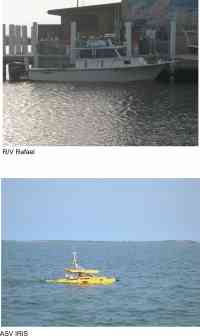
Survey PlatformsTwo survey platforms were used to collect geophysical data in Apalachicola Bay (fig. 2). The R/V Rafael, a 6.3 m outboard-motor propelled vessel with an ~ 1.5 m draft, was used to survey sections of the bay where water depths exceeded 2 m during two cruises (March 14-April 13, 2005, and May 29-June 27, 2006).During June 3-27, 2006, IRIS, an Autonomous Surface Vehicle (ASV), was used to survey sections of the bay where water depths were between 0.75 and 2 m. IRIS is a 2-m long, battery-powered remote vehicle that surveys pre-programmed tracklines. Bathymetric, sidescan-sonar, seismic-reflection, and navigation data were all collected from both platforms.
|
Click on figure for larger image.
|
![]() Title |
Figures |
1-Introduction |
2-Data Collection and Processing |
3- Geologic Interpretation |
4-References |
5-Maps |
Spatial Data |
Acknowledgments
Title |
Figures |
1-Introduction |
2-Data Collection and Processing |
3- Geologic Interpretation |
4-References |
5-Maps |
Spatial Data |
Acknowledgments

![]() U.S. Department of the Interior |
U.S. Geological Survey
U.S. Department of the Interior |
U.S. Geological Survey
URL: http://pubsdata.usgs.gov/pubs/of/2006/1381/html/survey.htm
Page Contact Information: GS Pubs Web Contact
Page Last Modified: Friday, 16-Aug-2024 09:16:05 EDT