Open-File Report 2006-1381
Geophysical Mapping of Oyster Habitats in a Shallow Estuary; Apalachicola Bay, Florida
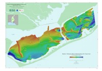
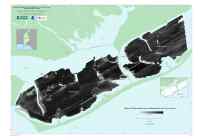
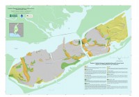
Three large-format mapsheets (1:30,000) illustrate the bathymetry, sidescan-sonar backscatter data, and surficial geology of the Apalachicola Bay and St. George Sound survey areas. These mapsheets are distributed as Adobe portable document format (PDF) files that can be printed on a large format plotter at 45 x 32 inches.
|
![]() To view files in PDF format, download free copy of Adobe Reader.
To view files in PDF format, download free copy of Adobe Reader.
![]() Title |
Figures |
1-Introduction |
2-Data Collection and Processing |
3- Geologic Interpretation |
4-References |
5-Maps |
Spatial Data |
Acknowledgments
Title |
Figures |
1-Introduction |
2-Data Collection and Processing |
3- Geologic Interpretation |
4-References |
5-Maps |
Spatial Data |
Acknowledgments

![]() U.S. Department of the Interior |
U.S. Geological Survey
U.S. Department of the Interior |
U.S. Geological Survey
URL: http://pubsdata.usgs.gov/pubs/of/2006/1381/html/maps.htm
Page Contact Information: GS Pubs Web Contact
Page Last Modified: Friday, 16-Aug-2024 09:08:06 EDT