USGS-NPS-NASA EAARL Topography

LIDAR Illustration

Home Link

Purpose Link

PDF Maps-Current Page

Raw Data Link

ArcMap Document Link

Metadata Link

Collaborators Link


PDF Map Index


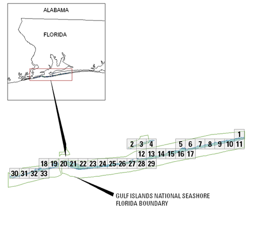
To view a Lidar map as a PDF file, select the appropriate link using either the map or from the geographic location listed below. These maps were designed to be printed at 34x44", but can be scaled, within the printer dialog window, to fit smaller page sizes.

To expedite download times and to prevent any possible errors, right click on the desired PDF map tile and save the file to disk. If you require all of the map tiles or would like a copy of the Open-File Report in DVD format, please contact: Emily Klipp in the USGS, FISC St. Petersburg office: eklipp@usgs.gov.


Click on a tile number (1-33) in the map below to view the corresponding map tile as a PDF file.

Gulf Islands National Seashore-Florida map Tile 30 Tile 31 Tile 32 Tile 33 Tile 18 Tile 19 Tile 20 Tile 21 Tile 22 Tile 23 Tile 24 Tile 25 Tile 26 Tile 27 Tile 28 Tile 29 Tile 12 Tile 2 Tile 3 Tile 4 Tile 13 Tile 14 Tile 15 Tile 16 Tile 17 Tile 5 Tile 6 Tile 7 Tile 8 Tile 9 Tile 10 Tile 11 Tile 1


  • Island Topography PDF files

To view a tile as a PDF file, download a free copy of Adobe Reader:    Get Adobe Reader

Accessibility FOIA Privacy Policies and Notices

Take Pride in America logo USA.gov logoU.S. Department of the Interior | U.S. Geological Survey
URL: https://pubsdata.usgs.gov/pubs/of/2007/1422/HTML/pdf_maps.html
Page Contact Information: Feedback
Page Last Modified: 20:47:38 Wed 07 Dec 2016