U.S. Geological Survey Open-File Report 2008-1196
Enhanced Sidescan-Sonar Imagery Offshore of Southeastern Massachusetts
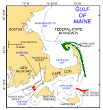
The U.S. Geological Survey (USGS), in cooperation with the National Oceanic and Atmospheric Administration (NOAA) and the Massachusetts Office of Coastal Zone Management (MA CZM), is producing detailed geologic maps of the coastal sea floor. As part of this cooperative project, sidescan-sonar imagery is being interpreted to delineate sediment distribution, sedimentary environments, and other sea-floor features (Poppe and others, 2006a, b; Poppe and others, 2007a, b; Poppe and others, 2008). The mosaics presented herein were derived from NOAA hydrographic surveys conducted in the vicinity of Quicks Hole—a passage through the Elizabeth Islands, which extend in a chain southwest of Cape Cod—and from Great Round Shoal Channel, a passage between Nantucket and Cape Cod (fig. 1). Although the sidescan-sonar imagery produced from data collected during NOAA hydrographic surveys is acceptable for charting purposes, it contains tonal artifacts due to environmental conditions (such as sea state), variable system settings (such as gain changes), attitude variations in the flight path of the towfish, or processing (such as lack of line-to-line normalization or failure to overwrite the 16-bit shift factor in Computer-Aided Resource Information System (CARIS)). These artifacts give the original imagery a quilt-like patchwork appearance that does not accurately represent the relative backscatter properties of the sea floor, and make it difficult to distinguish geologic features and trends in the sonar imagery. The purpose of this report is to release enhanced sidescan-sonar imagery from two surveys offshore of southeastern Massachusetts that (1) provide continuous grayscale perspectives of the backscatter, (2) accentuate sea-floor geologic trends, and (3) minimize environment-, acquisition-, and processing-related noise. The enhanced imagery will benefit future studies of these ecologically important nearshore areas (Noji and others, 2004). |
|

![]() U.S. Department of the Interior |
U.S. Geological Survey
U.S. Department of the Interior |
U.S. Geological Survey
URL: http://pubsdata.usgs.gov/pubs/of/2008/1196/html/intro.html
Page Contact Information: GS Pubs Web Contact
Page Last Modified: Wednesday, 07-Dec-2016 21:37:07 EST