 |
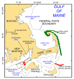
Figure 1. Index map of Cape Cod and the Islands showing the locations of National Oceanic and Atmospheric Administration surveys H11076 of Quicks Hole (Poppe and others, 2007a) and H11079 of Great Round Shoal Channel (Poppe and others, 2007b), Massachusetts (in red). Also shown in green are the locations of other surveys being interpreted as part of this series (Outer Cape Cod: Poppe and others, 2006a,b; Woods Hole: Poppe and others, 2008). |
 |
Figure 2. Port-side view of the National Oceanic and Atmospheric Administration Ship Thomas Jefferson at sea. The 30-foot survey launch normally stowed on this side of the ship has been deployed. |
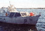 |
Figure 3. Starboard-side view of National Oceanic and Atmospheric Administration Launch 1014 afloat.
|
 |
Figure 4. The Klein 5000 sidescan-sonar system mounted on the hull of National Oceanic and Atmospheric Administration Launch 1014.
|
 |
Figure 5. The Klein 5000 sidescan-sonar towfish shown on the deck of the National Oceanic and Atmospheric Administration Ship Thomas Jefferson. |
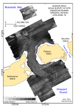 |
Figure 6. Original sidescan-sonar imagery from the National Oceanic and Atmospheric Administration survey of Quicks Hole, Massachusetts (Poppe and others, 2007a). Note the numerous tonal artifacts. Lighter tones represent harder returns and higher backscatter.
|
 |
Figure 7. Original sidescan-sonar imagery from the National Oceanic and Atmospheric Administration survey of Great Round Shoal Channel (Poppe and others, 2007b). Note the numerous tonal artifacts. Lighter tones represent harder returns and higher backscatter.
|
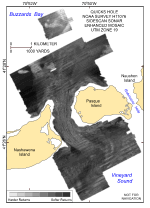 |
Figure 8. Enhanced sidescan-sonar imagery from the National Oceanic and Atmospheric Administration survey of Quicks Hole, Massachusetts. Lines of unnatural and abruptly different tone were matched to the surrounding backscatter. Lighter tones represent harder returns and higher backscatter. |
 |
Figure 9. Enhanced sidescan-sonar imagery from the National Oceanic and Atmospheric Administration survey of Great Round Shoal Channel. Lines of unnatural and abruptly different tone were matched to the surrounding backscatter. Lighter tones represent harder returns and higher backscatter. |
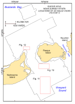 |
Figure 10. Map showing the boundary of the sidescan-sonar data from National Oceanic and Atmospheric Administration survey H11076 of Quicks Hole and the locations of the detailed comparative views of the mosaics shown in figures 11, 12, and 13.
|
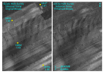 |
Figure 11. Detailed view of the original (left) and enhanced (right) sidescan-sonar mosaics from the southern part of the Quicks Hole survey by the National Oceanic and Atmospheric Administration. Note the tonal artifacts in the original mosaic and how removal of the artifacts presents a more continuous tonal character. Circles mark sampling and bottom-photography station locations (Poppe and others, 2007a); each is labeled with station number and mean grain-size value (phi). Locations of views are shown in figure 10. |
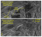 |
Figure 12. Detailed view of the original (top) and enhanced (bottom) sidescan-sonar mosaics from the northwestern part of the Quicks Hole survey by the National Oceanic and Atmospheric Administration. Note the tonal artifacts in the original mosaic and how removal of the artifacts clarifies the boulder distributions in the enhanced mosaic. Locations of views are shown in figure 10.
|
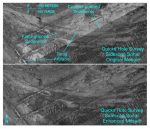 |
Figure 13. Detailed view of the original (top) and enhanced (bottom) sidescan-sonar mosaics from the southeastern part of the Quicks Hole survey by the National Oceanic and Atmospheric Administration. Note the tonal artifacts present in the original mosaic and how removal of the artifacts accentuates the current-swept character of the sea floor in the enhanced mosaic. Locations of views are shown in figure 10. |
 |
Figure 14. Map showing the boundary of the sidescan-sonar data from National Oceanic and Atmospheric Administration survey H11079 of Great Round Shoal Channel and the locations of the detailed views of the mosaics shown in figures 15 and 16. |
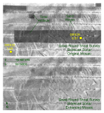 |
Figure 15. Detailed view of the original (top) and enhanced (bottom) sidescan-sonar mosaics from the western part of the Great Round Shoal Channel survey by the National Oceanic and Atmospheric Administration. Note the tonal artifacts in the original mosaic and how removal of the artifacts clarifies the character of the sand-wave field in the enhanced mosaic. Circles mark sampling and bottom-photography station locations, each labeled with station number and mean grain-size value (phi). Locations of views are shown in figure 14. |
 |
Figure 16. Detailed view of the original (left) and enhanced (right) sidescan-sonar mosaics from the Great Round Shoal Channel survey by the National Oceanic and Atmospheric Administration. Note the tonal artifacts in the original mosaic and how removal of the artifacts accentuates the current-swept character of the sea floor in the enhanced mosaic. Locations of views are shown in figure 14. |