U.S. Geological Survey Open-File Report 2008-1206
Coastal Change Along the Shore of Northeastern South Carolina: The South Carolina Coastal Erosion Study
Return to: Title and Abstract » Table of Contents » Section 1 » Section 2 » Section 3 » Section 4 » Section 5 » Section 6 » Acknowledgments » References » List of Figures » Acronymns » Glossary |
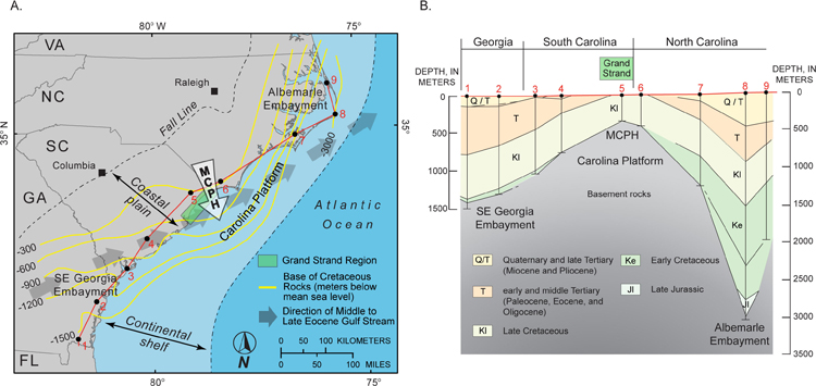
Figure 3.6. A) Map showing major structure and physiography of the southeast U.S. continental margin. Yellow contour lines indicate depth to the base of Cretaceous sedimentary rocks (adapted from Horton and others, 1991). Seaward-bulging contours indicate relatively thin post-Cretaceous deposits across the Carolina Platform, a major structural high that underlies the coastal plain and continental shelf. The Grand Strand is located near the apex of the Mid-Carolina Platform High (MCPH), which is the shallowest, most stable portion of the Carolina Platform. Gray arrows indicate the direction of an ancient ocean current, much like the modern Gulf Stream, which flowed across the MCPH during the Middle to Late Eocene and caused prolonged nondeposition and erosion (generalized from Popenoe, 1985). B) Geologic cross section constructed from deep borehole data (black dots #1-9) along the coast (red line in part A). Cretaceous rocks are at or near the surface along the Grand Strand, but more deeply buried by younger deposits within the Albemarle and Southeast Georgia Embayments, structural lows that bound the Carolina Platform on either side. Figure adapted from Gohn (1988). [Click here for high-resolution image.]
 |