U.S. Geological Survey Open-File Report 2008-1206
Coastal Change Along the Shore of Northeastern South Carolina: The South Carolina Coastal Erosion Study
Return to: Title and Abstract » Table of Contents » Section 1 » Section 2 » Section 3 » Section 4 » Section 5 » Section 6 » Acknowledgments » References » List of Figures » Acronymns » Glossary |
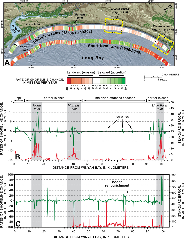
Figure 4.2. (A) Map view of the Grand Strand showing rates of shoreline change as color-coded bands parallel to the coast. Historical rates are based on shoreline positions derived from maps, charts, and air photographs. Short-term rates are based on shoreline positions measured by LIDAR surveys. Rates are calculated by using the linear rate-of-regression method (Thieler and others, 2003), which runs a best-fit line through all available data points. (B) Graph showing historical rates of shoreline change (green line) from the 1850s to 1980s. Highest rates of change are in the vicinity of inlets; lowest rates are along mainland-attached beaches. Standard error (red line) of the measurements indicates variability in shoreline positions through time. If the shoreline at a particular area shows high variability (that is, it moves back and forth a lot), standard error is high. Shoreline positions along inlets and barrier islands have higher variability and lower variability along mainland-attached beaches. (C) Graph showing short-term rates of shoreline change between 1996 and 2000. Shoreline positions along smaller inlets, swashes, and the beach renourishment project at Myrtle Beach show the largest amount of variation at this time scale. [Click here for high-resolution image.]
 |