U.S. Geological Survey Open-File Report 2008-1288
Geophysical Data Collected off the South Shore of Martha's Vineyard, Massachusetts
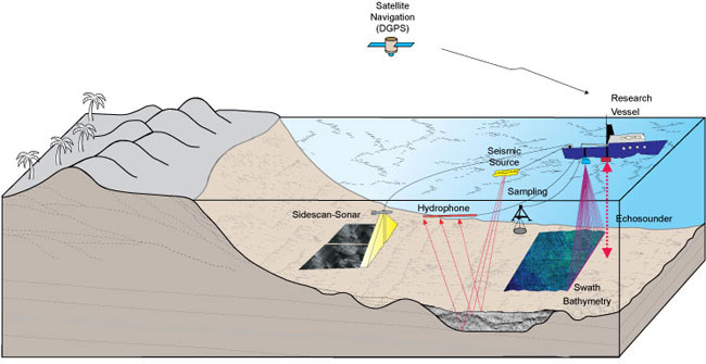 |
Figure 3. Illustration of the geophysical systems used to characterize the seafloor during USGS Cruise 07011. Sidescan sonar, swath bathymetric, and seismic-reflection systems were used to define the surficial sediment distribution, depth, and underlying geology. Sampling systems were used to collect direct samples of the seafloor sediment. A Differential Global Positioning System (DGPS) was used to navigate the sidescan-sonar and swath bathymetric systems, while a Global Positioning System (GPS) was used to navigate the seismic-reflection system.
|

![]() U.S. Department of the Interior |
U.S. Geological Survey
U.S. Department of the Interior |
U.S. Geological Survey
URL: https://pubsdata.usgs.gov/pubs/of/2008/1288/html/imagepages/figure3.html
Page Contact Information: Contact USGS
Page Last Modified: Wednesday, 07-Dec-2016 21:27:20 EST
