U.S. Geological Survey Open-File Report 2008-1288
Geophysical Data Collected off the South Shore of Martha's Vineyard, Massachusetts
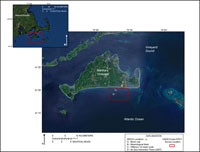
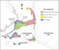
Martha's Vineyard is located off the southeastern coast of Massachusetts, approximately 6 kilometers (km) southeast of Cape Cod and the Elizabeth Islands (fig. 1). The present coastal landscape of Martha's Vineyard and the surrounding seafloor environment are products of glacial and modern oceanographic processes acting to form and reshape the region over the past 20,000 years. The most recent ice sheet, the Laurentide ice sheet of the Wisconsinan glaciation, advanced across southern New England and reached its maximum extent around 21,000 years before present (B.P.) (Oldale, 1992). As the ice sheet extended to the south, glaciers filled depressions in the underlying bedrock, forming Buzzards Bay, Cape Cod Bay, and South Channel lobes (fig. 2). Complex end moraines that formed at the junction of the Buzzards Bay and Cape Cod lobes mark the southern extent of the Laurentide Ice Sheet and lie along the northern coast of Martha's Vineyard (fig. 2). Seaward of the end moraines, extensive glacial outwash plains were deposited that now form the interior and southern shore of Martha's Vineyard (fig. 2). Subsequent to glacier retreat around 18,000 years B.P., large glacial deposits on the continental shelf became susceptible to erosion and reworking as sea level rose nearly 120 meters (m) to present-day levels (Oldale, 1992; Uchupi and Oldale, 1994). The action of waves, currents, and tides continues to shape the coast and adjacent seafloor deposits, providing an ideal setting for studying the dynamics of the coastal ocean and the processes influencing sediment transport. Today, the inner continental shelf off the southern shore of Martha's Vineyard is the focus of collaborative research efforts investigating the oceanographic and physical processes influencing sediment transport in the coastal ocean (Goff and others, 2005; Sherwood and others, 2009; Martha's Vineyard Coastal Observatory, 2009). Research efforts have utilized the Woods Hole Oceanographic Institution's (WHOI) Martha's Vineyard Coastal Observatory (MVCO), an integrated system providing continuous sampling of atmospheric and oceanographic processes at stable platforms positioned on the beach to several kilometers offshore (MVCO, 2009). In August 2007, the USGS conducted a high-resolution geophysical study in support of the Office of Naval Research (ONR) Ripples Directed-Research Initiative (DRI) studies at MVCO. The objectives of the survey were to define the bathymetry, sediment distribution, and underlying geology of the inner continental shelf offshore of Martha's Vineyard. These data will provide high-resolution datasets that will be used as initial conditions for oceanographic modeling (Sherwood and others, 2009) and as comparison to previously collected data (Goff and others, 2005). This report presents the geophysical data collected by the USGS (fig. 3). Data were acquired with the following geophysical systems: a Systems Engineering and Assessment, Ltd., SWATHplus interferometric sonar; a Klein Associates 3000 dual-frequency sidescan sonar; and an EdgeTech 512i chirp sub-bottom profiling system. This report details the data processing procedures employed, and presents the processed datasets within a Geographic Information System (GIS). This report also contains beach and seafloor sediment samples collected in 2005 and 2007. These sample data were collected to support the ONR Optics Acoustics and Stress In Situ (OASIS) and Ripples DRI instrumentation and modeling efforts rather than to ground-truth the geophysical data. Specifically, sample data were collected to locate the boundary between coarse and fine sediment prior to deployment and retrieval of instrumented tripods, and to document physical characteristics of the beach and seafloor sediment (Sherwood and others, 2009). |

![]() U.S. Department of the Interior |
U.S. Geological Survey
U.S. Department of the Interior |
U.S. Geological Survey
URL: https://pubsdata.usgs.gov/pubs/of/2008/1288/html/introduction.html
Page Contact Information: Contact USGS
Page Last Modified: Wednesday, 07-Dec-2016 21:27:31 EST