U.S. Geological Survey Open-File Report 2008-1288
Geophysical Data Collected off the South Shore of Martha's Vineyard, Massachusetts
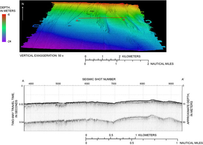 |
Figure 7. TOP: North-looking oblique view of color shaded-relief image of swath bathymetric data collected during USGS Cruise 07011. Depth is displayed in meters and ranges from approximately 6 to 24 m water depth. Vertical exaggeration is 50 times. Sun illumination is from the northeast. Location of seismic-reflection line is displayed. BOTTOM: seismic-reflection data collected during USGS Cruise 07011. See top image for location. Depth is displayed as two-way travel time. Approximate depth is displayed in meters and assumes a speed of sound of 1,500 meters per second. Seismic shot number is displayed across the top of the profile. Several features are visible within the seismic image. At shot 5000, a sub-surface channel is visible within the seismic record, and reflections from shots 7000 to 9000 reveal an unconformity underlying low-relief bedforms. The bedforms are visible within the swath bathymetric image.
|

![]() U.S. Department of the Interior |
U.S. Geological Survey
U.S. Department of the Interior |
U.S. Geological Survey
URL: https://pubsdata.usgs.gov/pubs/of/2008/1288/html/imagepages/figure7.html
Page Contact Information: Contact USGS
Page Last Modified: Wednesday, 07-Dec-2016 21:27:22 EST
