U.S. Geological Survey Open-File Report 2009-1002
|
Digital Seismic-Reflection Data from Western Rhode Island Sound, 1980by K.Y. McMullen¹, L.J. Poppe¹, and N.K. Soderberg¹ Published 2009
¹Coastal and Marine Geology Program, U.S. Geological Survey, Woods Hole, Mass. 02543
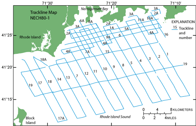
AbstractDuring 1980, the U.S. Geological Survey (USGS) conducted a seismic-reflection survey in western Rhode Island Sound aboard the Research Vessel Neecho. Data from this survey were recorded in analog form and archived at the USGS Woods Hole Science Center's Data Library. Due to recent interest in the geology of Rhode Island Sound and in an effort to make the data more readily accessible while preserving the original paper records, the seismic data from this cruise were scanned and converted to Tagged Image File Format (TIFF) images and SEG-Y data files. Navigation data were converted from U.S. Coast Guard Long Range Aids to Navigation (LORAN-C) time delays to latitudes and longitudes, which are available in Environmental Systems Research Institute, Inc. (ESRI) shapefile format and as eastings and northings in space-delimited text format. DisclaimerAny use of brand, trade, or firm names is for descriptive purposes only and does not imply endorsement by the U.S. Government.
|

![]() U.S. Department of the Interior |
U.S. Geological Survey
U.S. Department of the Interior |
U.S. Geological Survey
[an error occurred while processing this directive]
URL: https://pubsdata.usgs.gov
Page Contact Information: Contact USGS
Page Last Modified: Wednesday, 07-Dec-2016 21:55:31 EST