U.S. Geological Survey Open-File Report 2009-1151
Continuous Resistivity Profiling and Seismic-Reflection Data Collected in 2006 from the Potomac River Estuary, Virginia and Maryland
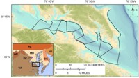
In September 2006 the U.S. Geological Survey (USGS) performed geophysical surveys along the western shore of Chesapeake Bay between the Patuxent River and the mouth of the Potomac River, as well as over a large area of the lower Potomac River Estuary. The research was undertaken in order to test hypotheses about groundwater flow under and into Chesapeake Bay and its tributaries (fig. 1). Managers of fisheries, wildlife, and other natural resources in the watershed are concerned about nutrients that are entering the estuary via submarine groundwater discharge (SGD) and are likely contributing to eutrophication. The USGS has performed many related studies in recent years to provide managers with information necessary to make informed decisions about this issue (for example, Cronin, 2000; Krantz and Powars, 2000; Bratton and others, 2002, 2003; Colman and Bratton, 2003; Willard and others, 2003; Brakebill and Preston, 2003; Cronin and others, 2007; Phillips, 2007; Sanford and others, 2009). This study was designed to refine nutrient budgets for Chesapeake Bay by characterizing spatial variations in salinity of submarine groundwater and the potential for discharge of terrestrially derived groundwater primarily beneath the Potomac River Estuary, as a tributary representative of several others on the western shore of Chesapeake Bay. During this investigation, a continuous resistivity profiling (CRP) survey was performed using a surface-towed streamer system in order to map areas of low-salinity groundwater by taking advantage of the relative differences in electrical resistivity associated with sub-estuarine sediments saturated with fresh groundwater (high resistivity) versus saline groundwater (low resistivity). Knowing where fresh groundwater extends beneath the estuary can help identify the ultimate mode and locations of groundwater discharge into the estuary and may assist resource managers in making decisions about the relative vulnerability of different parts of the estuary and its ecosystems to groundwater-driven eutrophication. Seismic-reflection data were also collected to assess controls on the occurrence of resistivity anomalies and to correlate these, where possible, with sedimentary structures such as buried paleochannels, ebb-tidal deltas, or near-surface fine-grained units or buried peats. Measurements of short-lived radioisotopic tracers of sub-estuarine groundwater discharge were also made in surface water in association with this geophysical survey; the corresponding methods and results are described separately (see also Hussain and others, 1999; Crusius and others, 2004, 2005). Based on previous studies in other estuaries, brackish to fresh groundwater was expected to underlie parts of the bay and the Potomac River Estuary, extending tens to hundreds of meters beyond the shoreline. Offshore flow documented at other locations has been shown to be related to the presence of low-permeability confining units at the sediment surface or in the shallow subsurface (Cross and others, 2008; Bratton and others, 2009). These sedimentary units act as aquitards to downward flow of dense overlying saline water and upward flow of underlying fresh water (Bratton, 2007). These conditions are likely widespread in Chesapeake Bay and along other estuarine and coastal shorelines where comparable geological conditions are present. SettingThe hydrogeology of the lower Potomac River Estuary is categorized broadly as “alluvial and estuarine valleys” (Hydrogeologic Subregion 7 of the Mid-Atlantic Coastal Plain) by Ator and others (2005). This classification scheme was based primarily on delineation by physiography and grain size of surficial sediments in the region. The depth of lowstand river incision into older underlying sediments is approximately 34 to 54 meters below modern sea level in the lower Potomac paleovalley (Owens, 1967; Knebel and others, 1981; Colman and others, 1990). The incised valley is filled with sediments of mostly late Pleistocene to Holocene age, fining upward from sands and gravels at depth, deposited in river channels during sea-level lowstands, to fine-grained recent and modern estuary sediments in the upper infill (Knebel and others, 1981; Callender and others, 1984). Wetlands and organic-rich sediments, common in low-relief shoreline areas, generally create reducing conditions in surficial aquifers (Ator and others, 2005). At the local scale, there is significant variation in grain size of surficial sediments and heterogeneity in chemistry of groundwater (both reducing and oxidizing conditions) in the shallow aquifers in this area. The hydrogeology of the surficial and confined aquifers of areas adjacent to the estuary has been studied in detail by the USGS at Navy facilities located near the upstream and downstream limits of the survey area (Harlow and Bell, 1996; Klohe and Kay, 2007). Hydrogeologic characteristics similar to those of the Potomac River Estuary are found in the other major tributaries on the western shore of Chesapeake Bay: the Patuxent, Rappahannock, York, and James River estuaries. |