Skip past header information
USGS - science for a changing world

U.S. Geological Survey Open-File Report 2010-1332

GLORIA Sidescan-Sonar Imagery for Parts of the U.S. Exclusive Economic Zone and Adjacent Areas


Cayman Trough Mosaic Index Map

Skip past contents information
Title Page
Introduction
Methods
Aleutian Arc
Atlantic Coast
Bering Sea
Cayman Trough
  • Field Activities
  • Index Map & Data Links
  • Gulf of Alaska
    Gulf of Mexico
    Hawaii I
    Hawaii II
    Hawaii III
    Johnston Atoll
    Kingman-Palmyra
    Pacific Coast
    Puerto Rico
    Data Catalog
    Acknowledgments
    References
    List of Figures
    Contacts

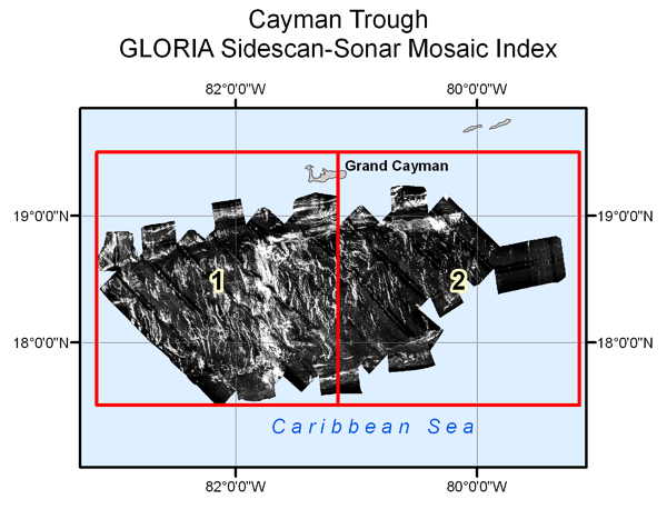
    Below is an index of the GLORIA imagery available for the Cayman Trough region. The raw GLORIA data were processed and digitally mosaicked to produce two mosaics of a 2-degree by 2-degree areaof continuous imagery of the seafloor. The index map contains links to a desampled, 250 m pixel version of the mosaic. To obtain a more detailed view of an individual mosaic, move the cursor over the mosaic area and click to select. A reduced version of the mosaic will be displayed in a separate browser window.

    To download the 50m mosaic with associated GIS information, please go to the data table. A single composite GLORIA image of the Cayman Trough region at a desampled 250-m pixel size also is available from the data table.

    Cayman Trough area GLORIA mosaic index map.
    Figure 27. Cayman Trough area GLORIA mosaic index map. Click to enlarge figure.

    The GLORIA sidescan-sonar composite mosaic for the Cayman Trough was completed using the following projection parameters:

    • Projection: Mercator
    • Datum - Ellipsoid: NAD27 / Clarke 1866

    Data Table

    zip icon The table below lists the composite and individual mosaics completed for the Cayman Trough region. Each mosaic has been compiled into a zip archive for easier download. The zip file contains the image in GeoTIFF format, projection information, world file, metadata, auxiliary supporting files, and browse graphics.

    Federal Geographic Data Committee (FGDC) metadata for the individual data layers is provided in HTML, FAQ, and text versions. Selecting associated metadata files from the table below will open the information in a new browser window.

    Compressed, downloadable files were created using the Windows program WINZIP v14.0. Users who do not have software capable of uncompressing the archived zip files can obtain a free version of the software from Winzip Computing, Inc., or Pkware, Inc.

     
    Bounds
     
    Mosaic
    Left
    Right
    Top
    Bottom
    Metadata
    Zip
    cym_250m_mer_nad27 83ow 79ow 19.5on 17.5on
    Click to download archive.
    cym_q01 83ow 81ow 19.5on 17.5on
    Click to download archive.
    cym_q02 81ow 79ow 19.5on 17.5on
    Click to download archive.


    Skip USGS links group

    Accessibility FOIA Privacy Policies and Notices

    Take Pride in America logo USAGov logo U.S. Department of the Interior | U.S. Geological Survey
    End of USGS links group

    Cayman Trough GLORIA mosaic 1. Cayman Trough GLORIA mosaic 2.