
|
| Click on figures for larger images. |
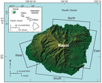 |
Figure 1. Map of Kauai showing shoreline study regions: north, east, south, west. |
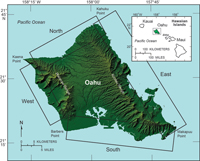 |
Figure 2. Map of Oahu showing shoreline study regions: north, east, south, west. |
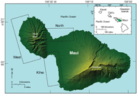 |
Figure 3. Map of Maui showing shoreline study regions: north, Kihei, west. |
Data in this report are available as downloadable files based on the 11 geomorphic regions within the Kauai ( fig. 1), Oahu ( fig. 2), and Maui ( fig. 3) study areas. These index maps show the extent of each region. All vector data are delivered as ESRI shapefiles in the geographic coordinate system (WGS84) and distributed with Federal Geographic Data Committee- (FGDC) compliant metadata in Extensible Markup Language (*.xml) format. Tabular data are delivered as dBase IV (*.dbf) structured files, which can be read with ESRI ArcGIS software as well as many other available spreadsheet programs. Metadata are also provided for all spatial and tabular data in text (*.txt) and FGDC Classic (*.html) format. ESRI ArcCatalog 9.x can also be used to examine the metadata in a variety of additional formats. This report includes all of the files necessary to perform shoreline-change analyses using the Digital Shoreline Analysis System (DSAS) software. Please refer to Thieler and others (2009) for information about the DSAS software application that was used to perform the rate calculation, which are discussed at length in the detailed report, National Assessment of Shoreline Change: Historical Shoreline Change in the Hawaiian Islands (Fletcher and others, 2011).
The following files are available for download for each geomorphic region (see index maps in figures 1-3):
- compiled shorelines from T-sheets and aerial photographs, which are attributed within each dataset and included in the metadata;
- offshore baseline used for generating shore-normal transects in DSAS;
- long-term transect file with rates; and
- short-term transect file with rates.
Data layers can be downloaded individually using the table below. Individual layers are provided as WinZip® files. If WinZip® is not currently installed on the local system, go to WinZip® (http://www.winzip.com) to download the most recent version.
|
|
|
|
|
|
Kauai |
|
|
|
|
|
| |
|
|
|
|
|
|
|
Kauai North |
|
|
|
|
|
File |
|
Description |
|
Metadata |
Download |
KauaiN_shorelines.shp |
|
Compiled shorelines and associated positional uncertainties for North Kauai region |
|
|
|
.html |
.zip |
.txt |
(260 KB) |
|
|
KauaiN_baseline.shp |
|
Offshore baseline for generating shore-normal transects in DSAS |
|
|
|
.html |
.zip |
.txt |
(76 KB) |
|
|
KauaiN_LT.shp |
|
Shore-normal transects and associated long-term rate calculations |
|
|
|
.html |
.zip |
.txt |
(106 KB) |
|
|
KauaiN_ST.shp |
|
Shore-normal transects and associated short-term rate calculations |
|
|
|
.html |
.zip |
.txt |
(107 KB) |
|
|
|
|
|
|
|
|
Kauai East |
|
|
|
|
|
File |
|
Description |
|
Metadata |
Download |
KauaiE_shorelines.shp |
|
Compiled shorelines and associated positional uncertainties for East Kauai region |
|
|
|
.html |
.zip |
.txt |
(199 KB) |
|
|
KauaiE_baseline.shp |
|
Offshore baseline for generating shore-normal transects in DSAS |
|
|
|
.html |
.zip |
.txt |
(61 KB) |
|
|
KauaiE_LT.shp |
|
Shore-normal transects and associated long-term rate calculations |
|
|
|
.html |
.zip |
.txt |
(86 KB) |
|
|
KauaiE_ST.shp |
|
Shore-normal transects and associated short-term rate calculations |
|
|
|
.html |
.zip |
.txt |
(89 KB) |
|
|
|
|
|
|
|
|
Kauai South |
|
|
|
|
|
File |
|
Description |
|
Metadata |
Download |
KauaiS_shorelines.shp |
|
Compiled shorelines and associated positional uncertainties for South Kauai region |
|
|
|
.html |
.zip |
.txt |
(159 KB) |
|
|
KauaiS_baseline.shp |
|
Offshore baseline for generating shore-normal transects in DSAS |
|
|
|
.html |
.zip |
.txt |
(59 KB) |
|
|
KauaiS_LT.shp |
|
Shore-normal transects and associated long-term rate calculations |
|
|
|
.html |
.zip |
.txt |
(83 KB) |
|
|
KauaiS_ST.shp |
|
Shore-normal transects and associated short-term rate calculations |
|
|
|
.html |
.zip |
.txt |
(84 KB) |
|
|
|
|
|
|
|
|
Kauai West |
|
|
|
|
|
File |
|
Description |
|
Metadata |
Download |
KauaiW_shorelines.shp |
|
Compiled shorelines and associated positional uncertainties for West Kauai region |
|
|
|
.html |
.zip |
.txt |
(100 KB) |
|
|
KauaiW_baseline.shp |
|
Offshore baseline for generating shore-normal transects in DSAS |
|
|
|
.html |
.zip |
.txt |
(68 KB) |
|
|
KauaiW_LT.shp |
|
Shore-normal transects and associated long-term rate calculations |
|
|
|
.html |
.zip |
.txt |
(96 KB) |
|
|
KauaiW_ST.shp |
|
Shore-normal transects and associated short-term rate calculations |
|
|
|
.html |
.zip |
.txt |
(97 KB) |
|
|
|
|
|
|
|
|
Oahu |
|
|
|
|
|
|
|
|
|
|
|
|
|
Oahu North |
|
|
|
|
|
File |
|
Description |
|
Metadata |
Download |
OahuN_shorelines.shp |
|
Compiled shorelines and associated positional uncertainties for North Oahu region |
|
|
|
.html |
.zip |
.txt |
(261 KB) |
|
|
OahuN_baseline.shp |
|
Offshore baseline for generating shore-normal transects in DSAS |
|
|
|
.html |
.zip |
.txt |
(81 KB) |
|
|
OahuN_LT.shp |
|
Shore-normal transects and associated long-term rate calculations |
|
|
|
.html |
.zip |
.txt |
(118 KB) |
|
|
OahuN_ST.shp |
|
Shore-normal transects and associated short-term rate calculations |
|
|
|
.html |
.zip |
.txt |
(119 KB) |
|
|
|
|
|
|
|
|
Oahu East |
|
|
|
|
|
File |
|
Description |
|
Metadata |
Download |
OahuE_shorelines.shp |
|
Compiled shorelines and associated positional uncertainties for East Oahu region |
|
|
|
.html |
.zip |
.txt |
(309 KB) |
|
|
OahuE_baseline.shp |
|
Offshore baseline for generating shore-normal transects in DSAS |
|
|
|
.html |
.zip |
.txt |
(120 KB) |
|
|
OahuE_LT.shp |
|
Shore-normal transects and associated long-term rate calculations |
|
|
|
.html |
.zip |
.txt |
(177 KB) |
|
|
OahuE_ST.shp |
|
Shore-normal transects and associated short-term rate calculations |
|
|
|
.html |
.zip |
.txt |
(178 KB) |
|
|
|
|
|
|
|
|
Oahu South |
|
|
|
|
|
File |
|
Description |
|
Metadata |
Download |
OahuS_shorelines.shp |
|
Compiled shorelines and associated positional uncertainties for South Oahu region |
|
|
|
.html |
.zip |
.txt |
(232 KB) |
|
|
OahuS_baseline.shp |
|
Offshore baseline for generating shore-normal transects in DSAS |
|
|
|
.html |
.zip |
.txt |
(83 KB) |
|
|
OahuS_LT.shp |
|
Shore-normal transects and associated long-term rate calculations |
|
|
|
.html |
.zip |
.txt |
(119 KB) |
|
|
OahuS_ST.shp |
|
Shore-normal transects and associated short-term rate calculations |
|
|
|
.html |
.zip |
.txt |
(119 KB) |
|
|
|
|
|
|
|
|
Oahu West |
|
|
|
|
|
File |
|
Description |
|
Metadata |
Download |
OahuW_shorelines.shp |
|
Compiled shorelines and associated positional uncertainties for West Oahu region |
|
|
|
.html |
.zip |
.txt |
(132 KB) |
|
|
OahuW_baseline.shp |
|
Offshore baseline for generating shore-normal transects in DSAS |
|
|
|
.html |
.zip |
.txt |
(51 KB) |
|
|
OahuW_LT.shp |
|
Shore-normal transects and associated long-term rate calculations |
|
|
|
.html |
.zip |
.txt |
(69 KB) |
|
|
OahuW_ST.shp |
|
Shore-normal transects and associated short-term rate calculations |
|
|
|
.html |
.zip |
.txt |
(70 KB) |
|
|
|
|
|
|
|
|
Maui |
|
|
|
|
|
|
|
|
|
|
|
|
|
Maui North |
|
|
|
|
|
File |
|
Description |
|
Metadata |
Download |
MauiN_shorelines.shp |
|
Compiled shorelines and associated positional uncertainties for North Maui region |
|
|
|
.html |
.zip |
.txt |
(110 KB) |
|
|
MauiN_baseline.shp |
|
Offshore baseline for generating shore-normal transects in DSAS |
|
|
|
.html |
.zip |
.txt |
(64 KB) |
|
|
MauiN_LT.shp |
|
Shore-normal transects and associated long-term rate calculations |
|
|
|
.html |
.zip |
.txt |
(94 KB) |
|
|
MauiN_ST.shp |
|
Shore-normal transects and associated short-term rate calculations |
|
|
|
.html |
.zip |
.txt |
(95 KB) |
|
|
|
|
|
|
|
|
Maui Kihei |
|
|
|
|
|
File |
|
Description |
|
Metadata |
Download |
MauiK_shorelines.shp |
|
Compiled shorelines and associated positional uncertainties for Kihei Maui region |
|
|
|
.html |
.zip |
.txt |
(166 KB) |
|
|
MauiK_baseline.shp |
|
Offshore baseline for generating shore-normal transects in DSAS |
|
|
|
.html |
.zip |
.txt |
(31 KB) |
|
|
MauiK_LT.shp |
|
Shore-normal transects and associated long-term rate calculations |
|
|
|
.html |
.zip |
.txt |
(92 KB) |
|
|
MauiK_ST.shp |
|
Shore-normal transects and associated short-term rate calculations |
|
|
|
.html |
.zip |
.txt |
(92 KB) |
|
|
|
|
|
|
|
|
Maui West |
|
|
|
|
|
File |
|
Description |
|
Metadata |
Download |
MauiW_shorelines.shp |
|
Compiled shorelines and associated positional uncertainties for West Maui region |
|
|
|
.html |
.zip |
.txt |
(286 KB) |
|
|
MauiW_baseline.shp |
|
Offshore baseline for generating shore-normal transects in DSAS |
|
|
|
.html |
.zip |
.txt |
(93 KB) |
|
|
MauiW_LT.shp |
|
Shore-normal transects and associated long-term rate calculations |
|
|
|
.html |
.zip |
.txt |
(137 KB) |
|
|
MauiW_ST.shp |
|
Shore-normal transects and associated short-term rate calculations |
|
|
|
.html |
.zip |
.txt |
(134 KB) |
|
|
|


