Skip past header information
USGS - science for a changing world

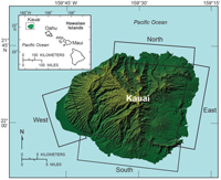
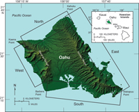
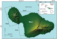
U.S. Geological Survey Open-File Report 2011-1009

National Assessment of Shoreline Change: A GIS Compilation of Vector Shorelines and Associated Shoreline Change Data for the Sandy Shorelines of Kauai, Oahu, and Maui, Hawaii


List of Figures

Skip past contents information
Thumbnail image and link to larger image of a map of Kauai showing shoreline study regions: north, east, south, west. Figure 1. Map of Kauai showing shoreline study regions: north, east, south, west.
Thumbnail image and link to larger image of a map of Oahu showing shoreline study regions: north, east, south, west. Figure 2. Map of Oahu showing shoreline study regions: north, east, south, west.
Thumbnail image and link to larger image of a map of Maui showing shoreline study regions: north, Kihei, west. Figure 3. Map of Maui showing shoreline study regions: north, Kihei, west.
Skip USGS links group

Accessibility FOIA Privacy Policies and Notices

Take Pride in America logo USAGov logo U.S. Department of the Interior | U.S. Geological Survey
End of USGS links group