U.S. Geological Survey Open-File Report 2011-1041
Continuous Resistivity Profiling Data from Northport Harbor and Manhasset Bay, Long Island, New York
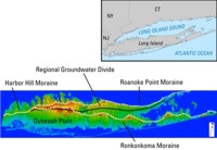
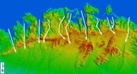
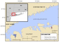
Like many coastal areas, the bays and harbors of Long Island's north shore are impacted by excess nutrients from multiple sources, resulting in harmful algal blooms, reduced oxygen concentrations, and other problems. This study was designed to examine submarine groundwater discharge as one route for delivery of nutrients to coastal waters and Long Island Sound. Although flow and water quality of streams and groundwater have been studied for many years on Long Island, few direct measurements or geophysical surveys of groundwater properties at the shoreline and offshore have been conducted, especially along the north shore. The modern geologic features of Long Island were formed by glacial activity during the last ice age and by subsequent subaerial erosion and marine processes during the Holocene. The Quaternary structure of the island is dominated by two glacial moraines, the Harbor Hill (north) and Ronkonkoma (south) (fig. 1). The eastern portion of the younger Harbor Hill Moraine is known as the Roanoke Point Moraine (Bennington and Hanson, 2010). The axes of both moraines trend east-west and merge to the west. Glacial outwash deposits of layered sand and gravel lie between the two moraines and to the south of the Ronkonkoma Moraine. The well-defined ridge that runs parallel to the central north shore of Long Island is primarily composed of the unsorted glacial till that makes up the Harbor Hill Moraine. The northern flanks of this moraine are cut into broad peninsulas or necks by a series of narrow, north-south-trending valleys that become embayments at the coast; the study areas of Manhasset Bay and Northport Harbor are two examples (fig. 2). These valleys likely formed by a combination of erosion in subglacial tunnel valleys (Bennington and Hanson, 2010), inherited preglacial topography, and postglacial erosion during sea level lowstands (Lewis and Stone, 1991; Lewis and DiGiacomo-Cohen, 2000). Beneath the embayments, these valleys are filled with varved clay, silt, and fine sand (over 100 meters (m) thick in some areas) that were likely deposited in small ice-proximal proglacial lakes as well Lake Connecticut, the large glacial lake that occupied most of what is now Long Island Sound (Stumm and others, 2002; Stone and others, 2005). Northport Harbor is a small dogleg-shaped subembayment of Northport Bay that is oriented north-south (fig. 3). It sits between flat-topped peninsulas that rise to approximately 50 m above sea level, which are cut by numerous steep valleys with irregular orientations. Shoreline slopes exceed 20 percent grades in some places, especially along the northern part of the eastern shoreline. The harbor is approximately 2 kilometers (km) long and 500 to 700 m wide, with an island (Bird Island) measuring approximately 500 m by 100 m located in the southern end. The tidal range in Northport Harbor is up to 3 m. Much of the shoreline along the harbor has been stabilized with bulkheads, especially along the eastern shore. Only a small portion of the Northport Harbor watershed is sewered; most homes are served by septic systems. Northport Harbor suffers from frequent harmful algal blooms and high bacteria counts, commonly resulting in closure of beaches and shellfish beds (Hattenrath and others, 2010). Manhasset Bay, the second study area, is located near the western end of Long Island Sound along the north shore of Long Island (fig. 3). The bay is approximately 7 km long and 1.5 km wide and has a surface area of approximately 11 square kilometers (km2), which is much larger than Northport Harbor's area. The average tidal range is 2.2 m. Manhasset Bay's watershed is less steep than the Northport Harbor watershed. The Manhasset Bay watershed is mostly sewered; three municipal wastewater treatment plants discharge effluent to the bay. Modeling studies have examined both discharge of groundwater to Long Island Sound from Long Island and intrusion of saltwater into aquifers on land due to pumping of groundwater (Scorca and Monti, 2001; Stumm and others, 2002; Monti and others, 2009). Coastal groundwater sampling, conducted as a companion project task to the CRP surveys described in this report, has shown differences in concentrations and the likely sources of nutrients discharging from the sewered and unsewered watersheds that were sampled (Zhao and others, 2011). |