
|
|
Click on figure for larger image. |
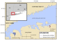 |
Figure 3. Location map showing the continuous resistivity tracklines in Manhasset Bay and Northport Harbor on the north shore of Long Island, New York. |
The CRP profile previews are broken down by area of acquisition during the 2008 survey (fig. 3). These CRP profiles are available for viewing from their respective survey pages and are available for download from the Data Catalog page. The thumbnails on the preview pages provide a quick visual representation of the data collected. In addition, these pages provide links to larger versions of the profiles, as well as an interactive (clickable) trackline map that shows the spatial orientation and location of the profiles.
|


