Skip past header information
USGS - science for a changing world
NOAA Logo with link to NOAA Home Page.Massachusetts CZM Logo with link to MA CZM Home Page.  

U.S. Geological Survey Open-File Report 2011–1222

Sea-Floor Geology and Sedimentary Processes in the Vicinity of Cross Rip Channel, Nantucket Sound, Offshore Southeastern Massachusetts


Skip past contents information

Title | List of Figures | Conversion Factors | Abstract | Introduction | Setting | Methods | Bathymetry | Sediment Distribution | Bottom Photography | GIS Data Catalog | Summary | Acknowledgments | References | Contacts


Figure 20. An image showing the sea floor in the axis of Cross Rip Channel.

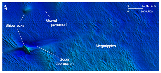
Figure 20. Detailed planar view of the bathymetric data collected during National Oceanic and Atmospheric Administration survey H12007 showing the sea floor along the axis of Cross Rip Channel. Note that asymmetrical scour around the shipwreck indicates net eastward transport and that the sea floor is dominated by megaripples and small patches of gravel pavement. Location of view is shown in figure 19.

Skip USGS links group

Accessibility FOIA Privacy Policies and Notices

Take Pride in America logo USAGov logo U.S. Department of the Interior | U.S. Geological Survey
End of USGS links group