Skip past header information
USGS - science for a changing world
NOAA Logo with link to NOAA Home Page.Massachusetts CZM Logo with link to MA CZM Home Page.  

U.S. Geological Survey Open-File Report 2011–1222

Sea-Floor Geology and Sedimentary Processes in the Vicinity of Cross Rip Channel, Nantucket Sound, Offshore Southeastern Massachusetts


Skip past contents information

Title | List of Figures | Conversion Factors | Abstract | Introduction | Setting | Methods | Bathymetry | Sediment Distribution | Bottom Photography | GIS Data Catalog | Summary | Acknowledgments | References | Contacts


Figure 29. Cross sectional view of megaripples in the study area.

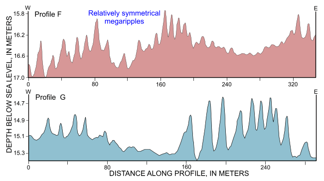
Figure 29. Cross-sectional views of megaripples produced from the digital terrain model of bathymetric data collected during National Oceanic and Atmospheric Administration survey H12007 in the southeastern part of the study area. The megaripples are predominantly symmetrical, indicating little or no net transport. Locations of profiles are shown in figure 19.

Skip USGS links group

Accessibility FOIA Privacy Policies and Notices

Take Pride in America logo USAGov logo U.S. Department of the Interior | U.S. Geological Survey
End of USGS links group