U.S. Geological Survey Open-File Report 2012-1002
High-Resolution Geophysical Data from the Inner Continental Shelf: Buzzards Bay, Massachusetts

|
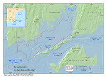
This report presents high-resolution spatial data for the seafloor of Buzzards Bay, Massachusetts (fig. 1). Approximately 410 square kilometers (km²) of the seafloor was mapped within Buzzards Bay in water depths of 4 to 46 meters (m). This report is the eighth published in a series (Ackerman and others, 2006; Andrews and others, 2010; Barnhardt and others, 2006, 2009, 2010; Pendleton and others, 2011; Turecek and others, 2012) produced by a cooperative mapping program (http://woodshole.er.usgs.gov/project-pages/coastal_mass/) between the U.S. Geological Survey (USGS) and the Massachusetts Office of Coastal Zone Management (CZM). The marine geophysical data in this report were obtained during three USGS research cruises in 2009, 2010 and 2011 (aboard the motor vessel (MV) Megan T. Miller and the MV Scarlett Isabella) and one National Oceanic and Atmospheric Administration (NOAA; aboard the NOAA ship Rude) hydrographic survey in 2004 (fig. 2). Existing multibeam-echosounder bathymetry data, collected by NOAA to update navigation charts in the region, have been used throughout this mapping program to help characterize seafloor geology and morphology. The overall goal of this cooperative is to characterize the seafloor and shallow substrate inside the 3-mile limit of State waters, using high-resolution geophysical techniques, sediment sampling, and seafloor photography and videography. The products developed and the knowledge gained in this project have broad applicability to scientific and resource-management issues in the region. The seabed characterization maps and geospatial data help scientists understand the processes that have shaped the coast and how the coast has evolved over time, thereby helping to evaluate the vulnerability of these coastal environments to storms, sea-level rise, and long-term climate change. This report provides a firm science foundation that will be the basis for managing marine habitats, addressing offshore development projects, and assessing environmental changes caused by natural processes or human activities. Geographic SettingBuzzards Bay is a coastal embayment located in southeastern Massachusetts (fig. 1). The southeast coast of Massachusetts, the west coast of Cape Cod, and the Elizabeth Islands partly enclose the bay. The mouth of the bay is open to Rhode Island Sound to the southwest. The bay communicates with Vineyard Sound through narrow straits between the Elizabeth Islands, Quicks Hole and Woods Hole being the largest. The Cape Cod Canal connects the head of Buzzards Bay with Cape Cod Bay where the Manomet River was excavated during construction of the canal in 1914. Several rivers enter elongated bays (drowned valleys) along the northwest shore between the canal and the Rhode Island border. The headlands between valleys extend into the bay and are also expressed in the seafloor bathymetry. Smaller rivers drain from Cape Cod into the bay and form bays and harbors. Buzzards Bay has a mean water depth of 11 m below the Mean Low Water (MLW) datum with mean depths of 5 to 10 m near the head and 20 m near the mouth of the bay (Signell, 1987). Geologic SettingThe geology and evolution of the Buzzards Bay basin is a result of the underlying bedrock structure, glacial processes related to late Pleistocene advance and retreat of the Buzzards Bay lobe of the Laurentide ice sheet, and marine processes associated with subsequent Holocene transgression and inundation. Proterozoic bedrock underlies the entire Buzzards Bay Basin (Zen and others, 1983). Cretaceous and early Tertiary strata were eroded during the late Tertiary and now exist southeast of Buzzards Bay beneath Vineyard Sound (O’Hara and Oldale, 1980). Subaerial erosion of the bedrock surface established a southerly flowing drainage surface, which is expressed in the present ridge and valley topography of northwestern Buzzards Bay (FitzGerald and others, 1987). The depth to the bedrock surface varies from 0 to 25 meters below sea level (mbsl) along the northeast shore to the head of the bay and deepens to about 100 mbsl along the Elizabeth Islands (Oldale, 1969). The west coast of Cape Cod and the Elizabeth Islands formed with the readvance of the Buzzards Bay ice lobe and the deposition of the Buzzards Bay moraine about 18,000 years before present (BP; Oldale and O’Hara, 1984; Uchupi and others, 1996; Balco and others, 2002). With the retreat of the Buzzards Bay lobe, the Buzzards Bay outwash was deposited between the ice front and the Buzzards Bay moraine along the west coast of Cape Cod (Mather and others, 1942). At the same time glacial drift and glaciolacustrine sediment were also deposited beneath what is now Buzzards Bay (Robb and Oldale, 1977). Along the southeast coast of Massachusetts, till and underlying bedrock form headlands and glaciofluvial and glaciolacustrine fill outwash valleys (FitzGerald and others, 1987; Bent, 1995). As the Buzzards Bay lobe continued to retreat north, the Wareham pitted plain was deposited along the northeast shore of Buzzards Bay (Larson, 1982). These outwash valleys and drainage of Glacial Lake Cape Cod through the Monument (Manomet) River Valley outlet (Woodworth and Wigglesworth, 1934) contributed to establishing the post-glacial drainage pattern for the Buzzards Bay Basin. Post-glacial subaerial erosion and fluvial channel development persisted and modified the drainage basin until sea level transgression formed the Holocene regional unconformity. Estuarine followed by marine deposits filled or partially filled the fluvial channels, primarily in the deeper areas of the basin. The postglacial paleodrainage system remains partially expressed in the present bathymetry of the bay (Hough, 1940; Moore, 1963; Robb and Oldale, 1977). |

![]() U.S. Department of the Interior |
U.S. Geological Survey
U.S. Department of the Interior |
U.S. Geological Survey
URL: http://pubsdata.usgs.gov/pubs/of/2012/1002/html/introduction.html
Page Contact Information: GS Pubs Web Contact
Page Last Modified: Thursday, 02-May-2013 09:09:48 EDT