U.S. Geological Survey Open-File Report 2012–1005
Sea-Floor Character and Sedimentary Processes of Block Island Sound, Offshore Rhode Island
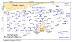
Sea-floor photography was collected at 86 stations within Block Island Sound as part of this study (fig. 14). The small SEABOSS system was used aboard the RV Rafael to obtain video photography and three to seven still photographs at each station as the vessel drifted over the seabed for 2-5 minutes. A total of 406 still photographs of the sea floor were obtained. The field of view of each image is approximately 50 cm wide (SEABOSS 50 cm above the bottom). Low-resolution images (150 pixels wide) of the photographs may be viewed by browsing the thumbnails in the photo galleries below. These thumbnails are hyperlinked to medium-resolution images (600 pixels wide) for more detailed viewing. Alternatively, the directory containing the full-resolution images may be accessed by clicking here. These full-resolution images can be identified using the .jpg image names in galleries below. Textural analyses of samples obtained at these stations, where available, are provided in the Sediments section of this report.
|

![]() U.S. Department of the Interior |
U.S. Geological Survey
U.S. Department of the Interior |
U.S. Geological Survey
URL: http://pubsdata.usgs.gov/pubs/of/2012/1005/html/photo.html
Page Contact Information: GS Pubs Web Contact
Page Last Modified: Tuesday, 22-Jul-2014 11:31:48 EDT