U.S. Geological Survey Open-File Report 2012–1005
Sea-Floor Character and Sedimentary Processes of Block Island Sound, Offshore Rhode Island
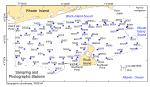
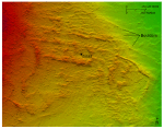
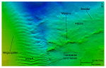
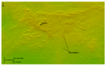
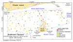
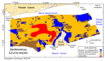
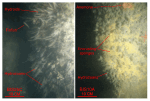
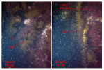
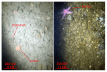
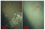
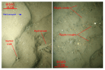
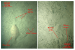
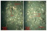
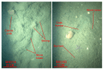
Sediments and Sedimentary EnvironmentsBoulders and gravel dominate the surficial sediment in high-energy sedimentary environments, such as along shorelines, on bathymetric highs, and on the floors of scour depressions (figs. 37, 38; for example, stations BIS83, BIS65, and BIS35). These are areas where the Holocene section is thin or absent, indicating that finer grained sediments have been eroded, exposing the coarser lag deposits of Pleistocene drift (figs. 19, 21, 22; Needell and Lewis, 1984). Boulders and cobbles, where present, are typically covered by sessile fauna, including hydrozoans, anemones, encrusting sponges, and hydroids (fig. 39). In shallow water (less than about 15 m), the boulders and cobbles are covered with green and red seaweed and, in places, kelp (fig. 40). The attached fauna and flora are ecologically important because they add to the overall benthic roughness and complexity and indicate that the coarser gravel is immobile even during severe storms. Pea- and pebble-sized gravels and gravelly sediments surround and are present within the bouldery deposits, armoring the underlying sea floor (fig. 41). Episodic mobilization of the finer grained gravel during storm events is suggested by the presence of only sparse sessile biota and, in deeper water, thin veneer of fine-grained sediment. Together, the gravels and gravelly sediments delineate areas of the sea floor characterized by sedimentary environments associated with processes dominated by long-term erosion or nondeposition (fig. 38; Knebel and others, 1982; Knebel and Poppe, 2000). While similar to linear scour depressions reported elsewhere (Cacchione and others, 1984; Garnaud and others, 2005) and on the shoreface along the south shore of Rhode Island (Oakley and others, 2009), floors of the storm-induced scour depressions in shallower waters offshore in Rhode Island Sound (Poppe and others, 2011; McMullen and others, 2011) and Block Island Sound are most commonly not rippled. We contend that the coarseness of exposed winnowed Pleistocene deposits is responsible for the absence of bedforms on the floors of these features. Ripples, however, become much more common on the floors of the storm-induced scour depressions in Block Island Sound as depth increases and the composition of the underlying deposits changes. In any case, the sediments on the floors of the scour depressions are almost always coarser that those on the surrounding sea floor (fig. 42). The storm-induced scour discussed above and in the bathymetry section of this report results in the juxtaposition of sea-floor areas in Block Island Sound with distinct boulder, gravel, sand, and muddy sand textures (fig. 38). This textural heterogeneity in turn creates a complex patchwork of contrasting sedimentary environments and, presumably, habitats. Our observations of local variations in community structure suggest that this small-scale textural heterogeneity adds dramatically to the regional sound-wide benthic biological diversity. Sand is the prevalent textural class across much of Block Island Sound (fig. 37). In shallower areas or near constrictions in the tidal flow, the sand is coarse- to medium-grained, clean (silt plus clay less than 1 percent), moderately well to moderately sorted, and ubiquitously rippled (fig. 43; for example stations BIS34, BIS37, and BIS82). Fields of sand waves and megaripples are variably present; moon snails, hermit crabs, cancer crabs, and sand dollars are varibly present; shell hash and gravel are concentrated in the ripple troughs; and sedimentary environments characterized by processes associated with coarse bedload transport prevail (fig. 38). In the deeper areas and areas away from constrictions in the tidal flow, the sand is typically fine- to very fine-grained, moderately to poorly sorted, muddier (silt plus clay 5-15 percent), and faintly rippled to undulating in appearance (fig. 44; for example, stations BIS70 and BIS80). Patchy distributions of small burrows, worm tubes, amphipod communities, skate, and flounder are common; thin, ephemeral accumulations of shell hash are variably present (fig. 45); and sedimentary environments characterized by processes associated with sorting and reworking prevail (fig. 38). Silty sand is the prevalent textural class only in the deeper, predominantly lower energy western parts of the study area (fig. 37; for example, stations BIS31 and BIS43). This area, which constitutes about 9 percent of the study area, is more protected from Atlantic storm events because it is bordered by Long Island to the west, the shallow top of the terminal moraine to the south, and Block Island to the southeast. The sand in this area is very fine grained, mud averages over 40 percent of the samples, and the sediments are poorly to very poorly sorted. The sea floor in these muddy areas has an undulating appearance and is heavily bioturbated, large and small burrows and worm tubes are abundant (fig. 46), and sea-floor sedimentary environments are characterized by the processes associated with deposition. Sediment DataThe sediment-grain-size dataset provided in the Data Catalog section of this report contains information on the collection, location, description, and texture of sediments at 86 stations occupied during the 2011 RV Rafael verification cruise 2011-006-FA (figs. 14, 37). All analyses were conducted in the Sedimentation Laboratory at the USGS Woods Hole Coastal and Marine Science Center in Woods Hole, Mass. Records without textural data and statistics are based on visual descriptions. The basic structure of the data is a flat-file format, a matrix where records are rows representing individual samples and the columns contain sample- and station-specific information. This matrix consists of 42 fields, which are defined in the Data Dictionary below. The sediment data are provided in three formats: ESRI shapefile, Microsoft Excel, and delimited ASCII text format. In the delimited ASCII text file, each field or column of data is separated from the next by commas and can be downloaded into many types of software. These files are available through the Data Catalog section of this report. Data DictionaryAn integral part of any database is the dictionary that explains the structure and content. It contains a list of the fields and the definitions of parameters measured. Data utilization is facilitated by reference to this compilation because it defines abbreviations and lists field names. LABNO - Unique sample identifier assigned in the laboratory STATIONID - Sample name or number assigned in the field PROJECT - Project under which samples were collected or data generated CRUISEID - Name or number of cruise on which sample was collected or station occupied PRINCIPAL - Name of principal investigator LATITUDE - Latitude in decimal degrees LONGITUDE - Longitude in decimal degrees (west longitudes are negative values) DEPTH_M - Depth of water measured by a hull-mounted fathometer overlying sediment at the time of sampling, not corrected for tides, in meters T_DEPTH - Top depth of the sample below the sediment-water interface, in centimeters B_DEPTH - Bottom depth of the sample below the sediment-water interface, in centimeters DEVICE - Device used to collect the sample MONTH - Number of calendar month during which the sample was collected DAY - Calendar day on which the sample was collected YEAR - Calendar year during which the sample was collected WEIGHT – Dry weight of sample, in grams ZGRAVEL - Gravel content in percent dry weight of the sample (particles with nominal diameters greater than 2 millimeters (-1 phi and larger)) ZSAND - Sand content in percent dry weight of the sample (particles with nominal diameters less than 2 millimeters but greater than or equal to 0.0625 millimeters (0 through 4 phi)) ZSILT - Silt content in percent dry weight of the sample (particles with nominal diameters less than 0.0625 millimeters but greater than or equal to 0.004 millimeters (5 through 8 phi)) ZCLAY - Clay content in percent dry weight of the sample (particles with nominal diameters less than 0.004 millimeters (9 phi and smaller)) SEDCLASS - Sediment description based on a rigorous definition (Shepard, 1954; Schlee, 1973; Poppe and others, 2004):
MEDIAN - Middle point in the grain-size distribution, in phi units MEAN - Average value in the grain-size distribution, in phi units STDDEV - Standard deviation (root mean square of the deviations) of the grain-size distribution, in phi units (that is, sorting) SKEWNESS - Deviation from symmetrical form of the grain-size distribution KURTOSIS - Degree of curvature near the mode of the grain-size distribution PHI _11 - Weight percent of the sample in the 11-phi fraction (nominal diameter of particles greater than or equal to 0.0005 millimeters but less than 0.001 millimeters); fine clay PHI_10 - Weight percent of the sample in the 10-phi fraction (nominal diameter of particles greater than or equal to 0.001 millimeters but less than 0.002 millimeters); medium clay PHI_9 - Weight percent of the sample in the 9-phi fraction (nominal diameter of particles greater than or equal to 0.002 millimeters but less than 0.004 millimeters); coarse clay PHI_8 - Weight percent of the sample in the 8-phi fraction (nominal diameter of particles greater than or equal to 0.004 millimeters but less than 0.008 millimeters); very fine silt PHI_7 - Weight percent of the sample in the 7-phi fraction (nominal diameter of particles greater than or equal to 0.008 millimeters but less than 0.016 millimeters); fine silt PHI_6 - Weight percent of the sample in the 6-phi fraction (nominal diameter of particles greater than or equal to 0.016 millimeters but less than 0.031 millimeters); medium silt PHI_5 - Weight percent of the sample in the 5-phi fraction (nominal diameter of particles greater than or equal to 0.031 millimeters but less than 0.0625 millimeters); coarse silt PHI_4 - Weight percent of the sample in the 4-phi fraction (nominal diameters of particles greater than or equal to .0625 millimeters but less than 0.125 millimeters); very fine sand PHI_3 - Weight percent of the sample in the 3-phi fraction (nominal diameter of particles greater than or equal to 0.125 millimeters but less than 0.25 millimeters); fine sand PHI_2 - Weight percent of the sample in the 2-phi fraction (nominal diameter of particles greater than or equal to 0.25 millimeters but less than 0.5 millimeters); medium sand PHI_1 - Weight percent of the sample in the 1-phi fraction (nominal diameter of particles greater than or equal to 0.5 millimeters but less than 1 millimeter); coarse sand PHI_0 - Weight percent of the sample in the 0-phi fraction (nominal diameters of particles greater than or equal to 1 millimeter but less than 2 millimeters); very coarse sand PHIM1 - Weight percent of the sample in the -1-phi fraction (nominal diameter of particles greater than or equal to 2 millimeters but less than 4 millimeters); very fine pebbles (granules) PHIM2 - Weight percent of the sample in the -2-phi fraction (nominal diameter of particles greater than or equal to 4 millimeters but less than 8 millimeters); fine pebbles PHIM3 - Weight percent of the sample in the -3-phi fraction (nominal diameter of particles greater than or equal to 8 millimeters but less than 16 millimeters); medium pebbles PHIM4 - Weight percent of the sample in the -4-phi fraction (nominal diameter of particles greater than or equal to 16 millimeters but less than 32 millimeters); coarse pebbles PHIM5 - Weight percent of the sample in the -5-phi fraction (nominal diameter of particles greater than or equal to 32 millimeters); very coarse pebbles to boulders |

![]() U.S. Department of the Interior |
U.S. Geological Survey
U.S. Department of the Interior |
U.S. Geological Survey
URL: http://pubsdata.usgs.gov/pubs/of/2012/1005/html/seds.html
Page Contact Information: GS Pubs Web Contact
Page Last Modified: Tuesday, 22-Jul-2014 11:48:22 EDT