U.S. Geological Survey Open-File Report 2012–1005
Sea-Floor Character and Sedimentary Processes of Block Island Sound, Offshore Rhode Island
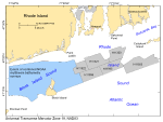
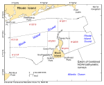
The digital terrain models (DTMs), imagery, interpretive data layers, and data presented herein were derived from multibeam echosounder data collected in Block Island Sound, offshore Rhode Island, and from the stations occupied to verify these acoustic data (fig. 1). Basic data layers show sea-floor topography and sun-illuminated shaded relief; interpretive layers show the distribution of sedimentary environments and sea-floor features. Presented verification data include sediment grain-size analyses and a gallery of still photographs of the seabed.The multibeam data, which together cover an approximately 634-km² area of sea floor, were collected during 2009 as part of National Oceanic and Atmospheric Administration (NOAA) hydrographic surveys H12009, H12010, H12011, H12015, H12033, H12137, and H12139 (fig. 2) and combined into one grid in order to provide a more regional prespective. Although originally collected for charting purposes, these acoustic data, and the sediment sampling and bottom photography used to verify them, also provide a fundamental framework for research and management activities off this part of the southern New England coastline (Noji and others, 2004), show the composition and terrain of the seabed, and provide information on sediment transport and benthic habitat.This publication is the eighth in a series of digital reports using acoustic data from NOAA hydrographic surveys to describe the sea-floor geology off Rhode Island (fig. 1). These surveys and the corresponding reports include: H11310, in central Narragansett Bay (McMullen and others, 2007a); H11320, off Sakonnet Point in north-central Rhode Island Sound (RIS) (McMullen and others, 2007b); H11321, in north-central RIS (McMullen and others, 2008); H11322, in northwestern RIS (McMullen and others, 2009a); H11996, in central RIS off Point Judith (McMullen and others, 2011); H11922, in eastern RIS off Gay Head (Poppe and others, 2011); and H11995, in central RIS (McMullen and others, 2012). As part of this effort, pre-existent analog seismic-reflection profiles collected by the U.S. Geological Survey (USGS), which can provide useful information on geologic framework, were scanned, converted into digital formats, and made available for Block Island Sound (Poppe and others, 2002), western RIS (McMullen and others, 2009b), and eastern RIS and vicinity (McMullen and others, 2009c). Together these publications also support the Massachusetts Sea-Floor Mapping Cooperative (Barnhardt and Andrews, 2006; Ackerman and others, 2012) by supplying data and maps that extend geologic and bathymetric coverages westward along the Rhode Island coastline. |

![]() U.S. Department of the Interior |
U.S. Geological Survey
U.S. Department of the Interior |
U.S. Geological Survey
URL: http://pubsdata.usgs.gov/pubs/of/2012/1005/html/intro.html
Page Contact Information: GS Pubs Web Contact
Page Last Modified: Tuesday, 22-Jul-2014 11:31:49 EDT