U.S. Geological Survey Open-File Report 2012–1103
Sea-Floor Character and Geology Off the Entrance to the Connecticut River, Northeastern Long Island Sound
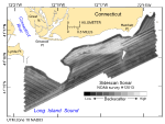
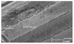
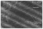
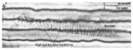
Distinctive tonal patterns revealed on the sidescan-sonar mosaic (fig. 31) include (1) complex patches of high and low backscatter with individual high-backscatter targets (objects), (2) alternating bands of high and low backscatter in a tiger-stripe pattern, (3) areas of relatively high backscatter (light tones), and (4) areas of relatively low backscatter (dark tones). Boundaries between patterns are commonly gradational, and backscatter is not uniform throughout these areas. Complex patches of high and low backscatter with individual high-backscatter targets delineate rocky, bouldery areas (fig. 32). The high backscatter component is produced by the sides of boulders and bedrock outcrops facing the sidescan source; the low backscatter component results from the shadow of the boulder or outcrop. Rocky areas on the mosaic are scattered along the Connecticut shoreline, concentrated off Hatchett Point and around and south of Hatchett Reef, and in a southeast-trending swath off Lynde Point. In places, turbulent currents flowing around boulders have produced comet structures. The tails of these structures commonly comprise higher backscatter, suggesting coarser grained sediment, current scour, and erosion (fig. 32). Areas characterized by alternating bands of high and low backscatter (figs. 33 and 34) include the southwestern edge of the study area, two east-northeast-trending swaths across its central and southern parts, and the flanks, top, and area north of Long Sand Shoal. This tiger-stripe pattern, which is produced by sand waves and megaripples, results from a combination of topographic changes affecting the angle of incidence of the sidescan sonar and the differences in sediment texture commonly present between crests and troughs of sand waves (Reineck and Singh, 1980). Parts of the study area characterized by relatively higher backscatter are most common in shallower waters and in the east-west-trending depression (figs. 31 and 34) where the sea floor is exposed to higher wave and tidal energy conditions, respectively. The areas of higher backscatter are generally produced by coarser grained sediments and shell debris. Patches characterized by relatively lower backscatter are present in deeper and more protected areas. The usefulness of this mosaic for examining relative changes in backscatter, however, is in places somewhat limited by poor tonal matching between adjacent lines. Examples of this problem are most conspicuous in the northernmost sidescan line and in the lines southeast of Hatchett Point (fig. 31). |