U.S. Geological Survey Open-File Report 2012–1103
Sea-Floor Character and Geology Off the Entrance to the Connecticut River, Northeastern Long Island Sound
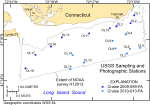
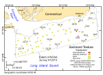
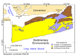
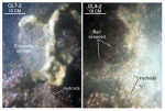
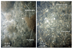
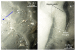
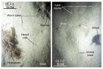
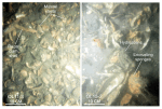
Sediments and Sedimentary EnvironmentsSurface-sediment texture in the study area ranges from boulders to very fine sand (fig. 35); sedimentary environments range from those characterized by processes associated with erosion and nondeposition to those characterized by sorting and reworking (fig. 36). Boulders are concentrated off Hatchett Point, on top of and around Hatchett Reef, and at scattered locations along the northern edge of the study area. These bouldery areas, which are present as lag deposits on bedrock outcrops and the winnowed surfaces of Pleistocene glacial drift, reflect higher energy sedimentary environments. Individual boulders are typically covered by sessile fauna (fig. 37), suggesting that they are immobile even during severe storms. The sessile fauna is ecologically important because it adds to the overall benthic roughness and commonly includes sponges, hydroids, bushy hydrozoans, and, when shallow enough to be well into the photic zone, seaweed and algae. Gravel (such as cobbles, pebble gravel, and pea gravel) surrounds the bouldery areas, armoring the sea floor and limiting further erosion (fig. 38). The gravel decreases in grain size to gravelly sediment, becomes patchy with distance from the boulders, and, although sessile biota covers the larger gravel, smaller gravel is clean, suggesting episodic transport of this finer fraction. Gravelly sediment also occurs at scattered locations in the south-central and southeastern parts of the study area. The sea floor in the southeastern part is relatively flat, and longitudinal ripples, an erosional bedform, and scour features around obstructions are common, suggesting that this is a sediment starved area. Sand dominates throughout most of the central and western parts of the study area. Bottom photography in these areas reveals a sea floor with well-developed current ripples (fig. 39) that have shell hash concentrated in the ripple troughs and with sedimentary environments characterized by processes associated with coarse-bedload transport (fig. 36). Sand in the vicinity of Long Sand Shoal tends to be moderately well sorted; elsewhere, sand tends to be more poorly sorted. Mud content of the sediment increases in protected places along the shoreline away from the mouth of the Connecticut River and east of Hatchett Point, where it approaches 20 percent under sedimentary environments characterized by processes associated with sorting and reworking. The sea floor in these areas is undulating to faintly rippled, and small to large burrows, polychaete and amphipod tubes, animal tracks, snails, whelk, and crabs are common (fig. 40). Muddy lithologies (those with silt plus clay greater than 25 percent) are uncommon but present in the study area. An unsampled cohesive muddy sediment, which we would argue is a drowned, partially buried marsh or lagoonal deposit, can be seen cropping out in a bottom photograph from station OL11 (fig. 41), and a silty sand was reported in historical data at a station just east of Hatchett Reef (Poppe and others, 1998a). Shell beds were observed at stations OL11 and OL15 in the depression that separates Hatchett Point from Hatchett Reef, at station OL3 around a rocky area off Hatchett Point, and at station OL5 in the southeastern part of the study area. The beds are of variable density but typically appear to be thin and patchy (fig. 41). Beds around rocky areas comprise primarily mussel shells (fig. 38); beds near the mouth of the Connecticut River comprise primarily oyster valves, some alive. The extent and amount of encrustation by barnacles, sponges, and hydrozoans indicate that most of the shells have been exposed on the sea floor for an extended time. These shell beds are ecologically important because they form sea-floor habitats of rough, relatively hard substrates that add considerably to the overall benthic compositional complexity. Bottom photography shows that infauna construct burrows in the shell deposits, juvenile finfish shelter between the shells, and sessile fauna and flora attach themselves to the hard substrate provided by the shells. Sediment DataThe sediment-grain-size dataset provided in the Data Catalog section of this report contains information on the collection, location, description, and texture of sediments at 18 stations occupied during R/V Rafael verification cruises 2009-059-FA and 2010-010-FA (figs. 15 and 35). All analyses were conducted in the Sedimentation Laboratory at the USGS Woods Hole Coastal and Marine Science Center in Woods Hole, Mass. Records without textural data and statistics are based on visual descriptions. The basic structure of the data is a flat-file format, a matrix where records are rows representing individual samples and the columns contain sample- and station-specific information. This matrix consists of 42 fields, which are defined in the Data Dictionary below. The sediment data are provided in three formats: Esri shapefile, Microsoft Excel, and delimited ASCII text format. In the delimited ASCII text file, each field or column of data is separated from the next by commas and can be downloaded into many types of software. These files are available through the Data Catalog section of this report. Data DictionaryAn integral part of any database is the dictionary that explains its structure and content. The dictionary contains a list of the fields and the definitions of parameters measured. Data utilization is facilitated by reference to this compilation because it defines abbreviations and lists field names. LABNO - Unique sample identifier assigned in the laboratory STATIONID - Sample name or number assigned in the field PROJECT - Project under which samples were collected or data generated CRUISEID - Name or number of cruise on which sample was collected or station occupied PRINCIPAL - Name of principal investigator LATITUDE - Latitude in decimal degrees LONGITUDE - Longitude in decimal degrees (west longitudes are negative values) DEPTH_M - Depth of water measured by a hull-mounted fathometer overlying sediment at the time of sampling, not corrected for tides, in meters T_DEPTH - Top depth of the sample below the sediment-water interface, in centimeters B_DEPTH - Bottom depth of the sample below the sediment-water interface, in centimeters DEVICE - Device used to collect the sample MONTH - Number of calendar month during which the sample was collected DAY - Calendar day on which the sample was collected YEAR - Calendar year during which the sample was collected WEIGHT – Dry weight of sample, in grams ZGRAVEL - Gravel (particles with nominal diameters greater than 2 millimeters (-1 phi and larger)) content of the sample, in percent dry weight ZSAND - Sand (particles with nominal diameters less than 2 millimeters but greater than or equal to 0.0625 millimeter (0 through 4 phi)) content of the sample, in percent dry weight ZSILT - Silt (particles with nominal diameters less than 0.0625 millimeter but greater than or equal to 0.004 millimeter (5 through 8 phi)) content of the sample, in percent dry weight ZCLAY - Clay (particles with nominal diameters less than 0.004 millimeter (9 phi and smaller)) content of the sample, in percent dry weight SEDCLASS - Sediment description based on a rigorous definition (Shepard, 1954; Schlee, 1973; Poppe and others, 2004) where, for sediments with gravel equal to or greater than 10 percent:
MEDIAN - Middle point in the grain-size distribution, in phi units MEAN - Average value in the grain-size distribution, in phi units STDDEV - Standard deviation (root mean square of the deviations) of the grain-size distribution (that is, sorting), in phi units SKEWNESS - Deviation from symmetrical form of the grain-size distribution KURTOSIS - Degree of curvature near the mode of the grain-size distribution PHI _11 - Weight percent of the sample in the 11-phi fraction (nominal diameter of particles greater than or equal to 0.0005 millimeter but less than 0.001 millimeter); fine clay PHI_10 - Weight percent of the sample in the 10-phi fraction (nominal diameter of particles greater than or equal to 0.001 millimeter but less than 0.002 millimeter); medium clay PHI_9 - Weight percent of the sample in the 9-phi fraction (nominal diameter of particles greater than or equal to 0.002 millimeter but less than 0.004 millimeter); coarse clay PHI_8 - Weight percent of the sample in the 8-phi fraction (nominal diameter of particles greater than or equal to 0.004 millimeter but less than 0.008 millimeter); very fine silt PHI_7 - Weight percent of the sample in the 7-phi fraction (nominal diameter of particles greater than or equal to 0.008 millimeter but less than 0.016 millimeter); fine silt PHI_6 - Weight percent of the sample in the 6-phi fraction (nominal diameter of particles greater than or equal to 0.016 millimeter but less than 0.031 millimeter); medium silt PHI_5 - Weight percent of the sample in the 5-phi fraction (nominal diameter of particles greater than or equal to 0.031 millimeter but less than 0.0625 millimeter); coarse silt PHI_4 - Weight percent of the sample in the 4-phi fraction (nominal diameters of particles greater than or equal to .0625 millimeter but less than 0.125 millimeter); very fine sand PHI_3 - Weight percent of the sample in the 3-phi fraction (nominal diameter of particles greater than or equal to 0.125 millimeter but less than 0.25 millimeter); fine sand PHI_2 - Weight percent of the sample in the 2-phi fraction (nominal diameter of particles greater than or equal to 0.25 millimeter but less than 0.5 millimeter); medium sand PHI_1 - Weight percent of the sample in the 1-phi fraction (nominal diameter of particles greater than or equal to 0.5 millimeter but less than 1 millimeter); coarse sand PHI_0 - Weight percent of the sample in the 0-phi fraction (nominal diameters of particles greater than or equal to 1 millimeter but less than 2 millimeters); very coarse sand PHIM1 - Weight percent of the sample in the -1-phi fraction (nominal diameter of particles greater than or equal to 2 millimeters but less than 4 millimeters); very fine pebbles (granules) PHIM2 - Weight percent of the sample in the -2-phi fraction (nominal diameter of particles greater than or equal to 4 millimeters but less than 8 millimeters); fine pebbles PHIM3 - Weight percent of the sample in the -3-phi fraction (nominal diameter of particles greater than or equal to 8 millimeters but less than 16 millimeters); medium pebbles PHIM4 - Weight percent of the sample in the -4-phi fraction (nominal diameter of particles greater than or equal to 16 millimeters but less than 32 millimeters); coarse pebbles PHIM5 - Weight percent of the sample in the -5-phi fraction (nominal diameter of particles greater than or equal to 32 millimeters); very coarse pebbles to boulders |