Open-File Report 2014–1012
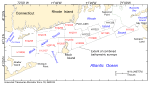
The U.S. Geological Survey (USGS), in cooperation with National Oceanic and Atmospheric Administration (NOAA), has produced detailed maps of the sea floor offshore of Rhode Island (fig. 1). The current phase of this cooperative research program is directed toward studies of sea-floor topography and its effect on the distributions of sediments and sedimentary environments. As part of this phase, individual hydrographic datasets are converted into Geographic Information System- (GIS-) compatible formats at 2-meter (m) resolution, verified with bottom photography and sampling, and geologically interpreted. Each of these GIS datasets, covering areas ranging from approximately 40 to 163 square kilometers (km²), individually provides important benthic environmental information, but many applications require a geographically broader perspective. The purpose of this report is to release 4-m raster grids and sun-illuminated GeoTIFFs of the integrated digital terrain models (DTMs) from multibeam-echosounder data collected during NOAA surveys H11922, H11995, H11996, H12009, H12010, H12011, H12015, H12023, H12033, H12137, H12139, H12296, H12298, and H12299. This resolution is adequate for sea-floor feature and process interpretation but is small enough to be queried and manipulated with standard GIS programs and to allow for future growth. These combined bathymetric surveys form a continuous 1244.5-km² area that covers most of Block Island Sound and extends eastward across Rhode Island Sound, providing a more regional perspective of the Rhode Island sea floor than previously available (fig. 1). The area covered by the new combined dataset released in this report also abuts the area covered by a combined multibeam dataset in Long Island Sound (Poppe and others, 2011a) and to the east in Buzzards Bay (Ackerman and others, 2012) and Vineyard Sound (Andrews and others, 2013). The Long Island Sound multibeam data were collected by NOAA and interpreted through a USGS and Connecticut Department of Energy and Environmental Protection cooperative. The Buzzards Bay and Vineyard Sound datasets were collected and interpreted by the USGS under the Massachusetts Mapping Cooperative (Barnhardt and Andrews, 2006) with the Massachusetts Office of Coastal Zone Management. Together these datasets extend contiguous detailed bathymetric coverage across much of the offshore area south of New England. Because anthropogenic wastes, toxic chemicals, and changes in land-use patterns resulting from residential, commercial, industrial, and recreational development have stressed the coastal environment south of New England, potentially causing degradation and loss of benthic habitats, detailed maps and interpretations of the sea floor are needed to evaluate the extent of adverse effects and to manage resources wisely in the future (U.S. Environmental Protection Agency, 1994; Rhode Island Coastal Resources Management Council, 2010). To that end, the detailed maps and datasets produced as part of this cooperative program serve many purposes, including (1) defining the topographic variability of the sea floor, which is one of the primary controls of benthic habitat diversity; (2) improving our understanding of the oceanographic processes that control the distribution and transport of bottom sediments and the distribution of benthic habitats and associated infaunal community structures; and (3) providing a detailed framework for future research, monitoring, and management activities. These datasets could also serve as base maps for subsequent sedimentological, geochemical, and biological observations because precise information on topography and environmental setting is important for the selection of sampling sites and for accurate extrapolation and interpretation of point measurements. |

![]() U.S. Department of the Interior |
U.S. Geological Survey
U.S. Department of the Interior |
U.S. Geological Survey
URL: http://pubsdata.usgs.gov/pubs/of/2014/1012/html/intro.html
Page Contact Information: GS Pubs Web Contact
Page Last Modified: Wednesday, 07-Dec-2016 19:33:23 EST