 |
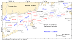
Figure 1. Locations of the surveys in Rhode Island and Block Island Sounds with multibeam echosounder data that have been combined in this report (polygons with red survey labels). Also shown are (1) the eastern extent of the contiguous multibeam data collected in Long Island Sound by the National Oceanic and Atmospheric Administration (NOAA) and geologically interpreted through a U.S. Geological Survey and Connecticut Department of Energy and Environmental Protection cooperative (dashed brown line; Poppe and others, 2011a); (2) the western extent of the bathymetry data collected by the Massachusetts Mapping Cooperative (dashed green line; Ackerman and others, 2012; Andrews and others, 2013); and (3) the locations of other surveys by NOAA that have been geologically interpreted as part of this series, but did not have continuous-coverage multibeam bathymetry (polygons with black labels; H11320—McMullen and others (2007); H11321—McMullen and others (2008); and H11322—McMullen and others (2009a). The surveys that compose the present study area and their respective reports that contain geological interpretations include H11922—Poppe and others (2011b); H11996—McMullen and others (2011); H11995—McMullen and others (2012); the combined Block Island Sound datasets H12009, H12010, H12011, H12015, H12033, H12137 and H12139 —Poppe and others (2012); H12023 —McMullen and others (2013) and H12296 —McMullen and others (2014); and H12298 and H12299 for which reports are in preparation. |
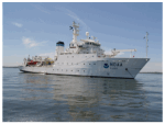 |
Figure 2. Starboard-side view of the National Oceanic and Atmospheric Administration (NOAA) Ship Thomas Jefferson at anchor. Photo courtesy of NOAA. |
 |
Figure 3. Launch 3102 being deployed from the National Oceanic and Atmospheric Administration Ship Thomas Jefferson. |
 |
Figure 4. Starboard-side view of the National Oceanic and Atmospheric Administration launch 3102 at sea. |
 |
Figure 5. The RESON Seabat 8125 multibeam echosounder hull-mounted to National Oceanic and Atmospheric Administration (NOAA) launch 3101. Photo courtesy of NOAA. |
 |
Figure 6. The RESON 7125 multibeam echosounder hull-mounted to the National Oceanographic and Atmospheric Administration (NOAA) Ship Thomas Jefferson. Photo courtesy of NOAA. |
 |
Figure 7. Brooke Ocean Technology Moving Vessel Profiler with a Sea-Bird Electronics, Inc. conductivity-temperature-depth (CTD) profiler used to correct sound velocities for the multibeam data collected aboard the ship. Photo courtesy of National Oceanic and Atmospheric Administration. |
 |
Figure 8. Sea-Bird Electronics, Inc., SEACAT conductivity-temperature-depth (CTD) profiler. Data derived from frequent deployments of this device were used to correct sound velocities for multibeam data collected aboard the launches. |
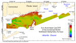 |
Figure 9. Digital terrain model (DTM) of the sea floor produced from the combined multibeam bathymetry collected during National Oceanic and Atmospheric Administration (NOAA) surveys H11922, H11995, H11996, H12009, H12010, H12011, H12015, H12023, H12033, H12137, H12139, H12296, H12298, and H12299 in Rhode Island and Block Island Sounds. Image is sun-illuminated from the northeast and vertically exaggerated by a factor of 5. Warmer colors denote shallower areas; cooler colors denote deeper areas. See key for depth ranges. |
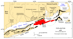 |
Figure 10. Map, modified from Stone and Borns (1986) and Gustavson and Boothroyd (1987), showing locations of end moraines (black polygons) in southern New England and on Long Island, New York. The Ronkonkoma-Nantucket moraine marks the Laurentide ice sheet's maximum southern extent about 20–28 thousand years ago, and the Harbor Hill-Roanoke Point-Charlestown-Buzzards Bay-Sandwich moraine represents the ice-sheet position after a readvance around 18–22.5 thousand years ago (Uchupi and others, 1996; Balco, 2011). Underwater extensions of the moraines are shown as dashed lines. Study area is shown as a red polygon. |
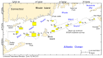 |
Figure 11. Locations of detailed planar views of the 4-meter digital terrain model (yellow polygons) produced from the contiguous National Oceanographic and Atmospheric Administration multibeam surveys in Rhode Island and Block Island Sounds. |
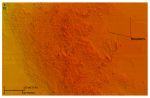 |
Figure 12. Detailed planar view of the sun-illuminated bathymetry from the combined National Oceanic and Atmospheric Administration surveys in Rhode Island and Block Island Sounds showing the bouldery sea floor near southwestern Block Island. Boulders rest on the winnowed upper surface of the submerged Montauk Point-Block Island segment of the terminal moraine. Location of view is shown in figure 11. Warmer colors denote shallower areas; cooler colors denote deeper areas. Depth key is shown in figure 9. |
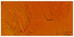 |
Figure 13. Detailed planar view of the sun-illuminated bathymetry from the combined National Oceanic and Atmospheric Administration surveys showing the bouldery sea floor south of Point Judith. Boulders rest on the winnowed upper surface of the submerged Point Judith segment of the Harbor Hill-Roanoke Point-Charlestown-Buzzards Bay-Sandwich end moraine. Location of view is shown in figure 11. Warmer colors denote shallower areas; cooler colors denote deeper areas. Depth key is shown in figure 9. |
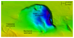 |
Figure 14. Detailed planar view of the sun-illuminated bathymetry from the combined National Oceanic and Atmospheric Administration surveys in Rhode Island and Block Island Sounds showing a deep isolated scour depression in a channel south of the eastern end of Fishers Island. The depression is more than 101 m deep and has been eroded into glaciolacustrine sediments underlying this part of Block Island Sound. Location of view is shown in figure 11. Warmer colors denote shallower areas; cooler colors denote deeper areas. Depth key is shown in figure 9. |
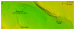 |
Figure 15. Detailed planar view of the sun-illuminated bathymetry from the combined National Oceanic and Atmospheric Administration surveys in Rhode Island and Block Island Sounds showing obstacle marks in southwestern Block Island Sound. Note that the obstacle-mark and sand-wave asymmetries indicate net northwestward sediment transport. Location of view is shown in figure 11. Warmer colors denote shallower areas; cooler colors denote deeper areas. Depth key is shown in figure 9. |
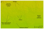 |
Figure 16. Detailed planar view of the sun-illuminated bathymetry from the combined National Oceanic and Atmospheric Administration surveys in Rhode Island and Block Island Sounds showing storm-wave-induced scour depressions on a seaward-facing slope in eastern Rhode Island Sound. The presence of boulders suggests that winnowed Pleistocene deposits are exposed in the northern part of the image. Note the relatively smooth appearance of the modern marine sediments and the presence of outliers and multibeam artifacts. Location of view is shown in figure 11. Warmer colors denote shallower areas; cooler colors denote deeper areas. Depth key is shown in figure 9. |
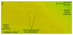 |
Figure 17. Detailed planar view of the sun-illuminated bathymetry from the combined National Oceanic and Atmospheric Administration surveys in Rhode Island and Block Island Sounds showing storm-wave-induced scour depressions on an isolated bathymetric high in central Rhode Island Sound. Note the multibeam artifact and the varied shapes, sizes, and orientations of the scour depressions. Location of view is shown in figure 11. Warmer colors denote shallower areas; cooler colors denote deeper areas. Depth key is shown in figure 9. |
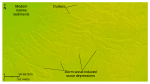 |
Figure 18. Detailed planar view of the sun-illuminated bathymetry from the combined National Oceanic and Atmospheric Administration surveys in Rhode Island and Block Island Sounds showing storm-wave-induced scour depressions on an isolated bathymetric high in western Rhode Island Sound. Note the presence of outliers of modern marine sediments. Location of view is shown in figure 11. Warmer colors denote shallower areas; cooler colors denote deeper areas. Depth key is shown in figure 9. |
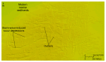 |
Figure 19. Detailed planar view of the sun-illuminated bathymetry from the combined National Oceanic and Atmospheric Administration surveys in Rhode Island and Block Island Sounds showing storm-wave-induced scour depressions on an isolated bathymetric high in southwestern Rhode Island Sound. Note the presence of outliers of modern marine sediments. Location of view is shown in figure 11. Warmer colors denote shallower areas; cooler colors denote deeper areas. Depth key is shown in figure 9. |
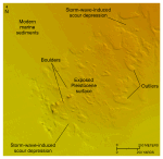 |
Figure 20. Detailed planar view of the sun-illuminated bathymetry from the combined National Oceanic and Atmospheric Administration surveys in Rhode Island and Block Island Sounds showing storm-wave-induced scour depressions on an isolated bathymetric high in eastern Rhode Island Sound. The presence of boulders suggests that winnowed Pleistocene deposits are exposed on the floor of the depression. Note the relatively smooth appearance of the modern marine sediments and the presence of outliers. Location of view is shown in figure 11. Warmer colors denote shallower areas; cooler colors denote deeper areas. Depth key is shown in figure 9. |
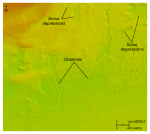 |
Figure 21. Detailed planar view of the sun-illuminated bathymetry from the combined National Oceanic and Atmospheric Administration surveys in Rhode Island and Block Island Sounds showing dendritic channels in the sea floor beneath northern Block Island Sound. Note that the channels start in storm-wave-induced scour depressions and that the channels merge downslope. Location of view is shown in figure 11. Warmer colors denote shallower areas; cooler colors denote deeper areas. Depth key is shown in figure 9. |
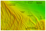 |
Figure 22. Detailed planar view of the sun-illuminated bathymetry from the combined National Oceanic and Atmospheric Administration surveys in Rhode Island and Block Island Sounds showing sand waves in the western part of the study area. Note that most of the sand waves have transverse morphologies, but that sand waves with barchanoid morphologies and straight-crested sand waves with moats are also present. Location of view is shown in figure 11. Warmer colors denote shallower areas; cooler colors denote deeper areas. Depth key is shown in figure 9. |
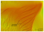 |
Figure 23. Detailed planar view of the sun-illuminated bathymetry from the combined National Oceanic and Atmospheric Administration surveys in Rhode Island and Block Island Sounds showing large transverse sand waves on a shoal west of Block Channel (fig. 1). Note that most of the sand-waves are symmetrical. Location of view is shown in figure 11. Warmer colors denote shallower areas; cooler colors denote deeper areas. Depth key is shown in figure 9. |
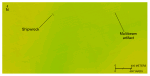 |
Figure 24. Detailed planar view of the sun-illuminated bathymetry from the combined National Oceanic and Atmospheric Administration surveys in Rhode Island and Block Island Sounds showing the relatively flat, featureless appearance of modern (Holocene) marine sediments, a shipwreck, and artifacts from multibeam acquisition and processing. The shipwreck is a German submarine sunk during World War II. Note the absence of asymmetrical scour around the wreck. Location of view is shown in figure 11. Warmer colors denote shallower areas; cooler colors denote deeper areas. Depth key is shown in figure 9. |

