Open-File Report 2014-1118
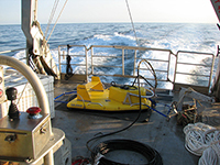
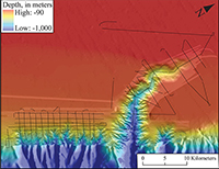
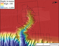
Data Acquisition and ProcessingData AcquisitionScientists from the U.S. Geological Survey surveyed Baltimore, Washington, and Norfolk Canyons aboard the MV Tiki XIV from May 22 to 27, 2012 (Julian day 143–148) (fig. 2). Data were acquired using a 46-microsecond sampling interval, a firing rate that varied with record length, and a 0.5- to 4.5-kilohertz swept frequency (except when otherwise noted). The record length was changed frequently to accommodate the variable water depths within and around the canyons. Survey speed was maintained at approximately 2 meters per second, and navigation fixes were logged using Differential Global Positioning System navigation. The survey tracklines were not planned in a regular, gridded pattern; tracklines were selected based on features of interest revealed by previous high-resolution bathymetric surveys (figs. 4, 5, and 6; Andrews and others, 2013). The chirp profiler was controlled and data were logged to a hard disk utilizing EdgeTech Discover software (fig. 3). The data were simultaneously recorded in both proprietary EdgeTech JSF format (EdgeTech, 2008) and Society of Exploration Geophysicists (SEG) SEG–Y rev. 1 standard format (Norris and Faichney, 2002). Data ProcessingPost-acquisition seismic data processing was performed through three programs: SIOSEIS (Henkart, 2011), Seismic Unix (Stockwell and Cohen, 2011), and IHS Kingdom Suite (IHS, 2013). Images of seismic-reflection profiles presented in this report represent the instantaneous amplitude (envelope) of the signal. Seismic-reflection profiles were swell filtered in the SIOSEIS program to remove ship heave in the following manner: the sea floor was automatically picked using a threshold amplitude value, and the traces were then vertically shifted relative to each other using a 20- to 50-trace moving average. Many of the profiles had artifact noise (on the same order of magnitude as the amplitude of the interface between the water and sea floor) in the first 10 milliseconds of the record, so the first 10 milliseconds of each trace in the noisy lines was muted to enable a more accurate pick of the sea floor. Some steeply dipping cross-canyon lines had lengths of weak water-bottom reflection amplitudes, so these lines were imported into Kingdom Suite where the water bottom was manually picked. The manual water-bottom picks were then exported as a comma-delimited text file and imported into SIOSEIS. The logged navigation was plotted in Esri ArcGIS v. 9.3 to produce polyline shapefiles and to help identify any erroneous navigation fixes. Final trace data, plotted as Portable Network Graphics (PNG) images, are presented in this report.
|

![]() U.S. Department of the Interior |
U.S. Geological Survey
U.S. Department of the Interior |
U.S. Geological Survey
URL: http://pubsdata.usgs.gov/pubs/of/2014/1118/ofr2014-1118-data-acquisition.html
Page Contact Information: GS Pubs Web Contact
Page Last Modified: Wednesday, 07-Dec-2016 19:36:16 EST