Open-File Report 2014-1118
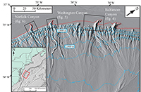
IntroductionThe U.S. Atlantic continental margin is one of the most widely studied margins in the world. In recent years, geophysical surveys conducted by Federal, State, and academic institutions have produced high-resolution views of sea-floor morphology across the outer continental shelf, slope, and rise between Cape Hatteras and Georges Bank (Chaytor and others, 2009; Twichell and others, 2009; Andrews and others, 2013; Brothers and others, 2013). Such surveys were aimed at filling gaps in data coverage and examining the fine-scale relationships between form and process within a series of major submarine canyons. This open-file report is intended to make available high-resolution chirp seismic-reflection data collected by the U.S. Geological Survey , in cooperation with the U.S. Nuclear Regulatory Commission and the Bureau of Ocean and Energy Management. The data were collected during USGS field activity 2012–005–FA in three of the major submarine canyons of the mid-Atlantic margin: Baltimore, Washington, and Norfolk Canyons (fig. 1). Submarine canyons are marine geological features that frequently span the distance from the continental shelf to the continental rise, two fundamentally different oceanographic and sedimentary regimes (Stanley and Moore, 1983). Submarine canyons play an important role in physical and biological processes along continental margins, particularly where canyons breach the shelf-edge (Palanques and others, 2005; Huvenne and others, 2011). The Eastern U.S. continental margin is thoroughly dissected by submarine canyons (including 30–40 shelf-breaching canyons), which makes them a fundamental part of Atlantic margin dynamics. The formational origins of shelf-breaching submarine canyons remains a topic of debate; as these canyons became widely studied in the 1970s and 1980s certain theories persisted because of a lack of contradictory evidence (Forde, 1981, Kelling and Stanley, 1970, McGregor and others, 1979). The theory of headward erosion proposed by Farre and others (1983) states that geologically young slope-confined canyons propagate upslope through local mass failure, consolidating smaller canyons and rills. Once these canyons are near the shelf-edge, the canyons capture fluvial sources that cross the continental shelf during sea-level lowstands. The sediment-laden fluvial input near the heads of the canyons further entrenches and widens them and can also incise a meandering canyon thalweg (Twichell and others, 1977). As part of an effort to assess the potential impact of submarine geohazards along the east coast of the U.S., three prominent mid-Atlantic submarine canyons were surveyed in 2012 by the U.S. Geological Survey aboard the motor vessel (MV) Tiki XIV. The goal of this survey was to assess the history of Holocene geological activity in and around Atlantic margin submarine canyons; therefore, a high-resolution, shallow-penetrating subbottom profiler (chirp sonar) was used. For an indepth interpretation of the data released in this report, the reader is directed to Obelcz and others (2014).
|

![]() U.S. Department of the Interior |
U.S. Geological Survey
U.S. Department of the Interior |
U.S. Geological Survey
URL: http://pubsdata.usgs.gov/pubs/of/2014/1118/ofr2014-1118-introduction.html
Page Contact Information: GS Pubs Web Contact
Page Last Modified: Wednesday, 07-Dec-2016 19:36:21 EST