Open-File Report 2014-1203
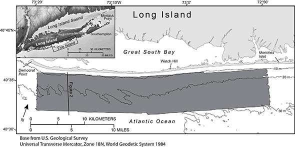
IntroductionApproximately 336 square kilometers (km2) of the lower shoreface and inner continental shelf offshore of Fire Island, New York, were mapped in water depths ranging from 8 to 32 meters (m; fig. 1). Geophysical data, including swath interferometric bathymetry and backscatter and chirp seismic-reflection profiles, were obtained in 2011 during a U.S Geological Survey (USGS) research cruise aboard the motor vessel (MV) Scarlett Isabella. This report presents the high-resolution bathymetry, acoustic backscatter, and derivative surfaces including the coastal plain unconformity, the Holocene marine transgressive surface and modern sediment thickness offshore of Fire Island, N.Y. (fig. 1). The primary goal of this investigation is to provide data in support of coastal processes research along the southern shore of Fire Island, N.Y. These data help scientists understand the evolution of the Fire Island coastal system over decadal to millennial time scales, thereby allowing an evaluation of the vulnerability of the coastal environment to storms, sea-level rise, and long-term climate change. This report adds to a scientific foundation for managing coastal systems and assessing environmental changes caused by natural processes and human activities. |
|

![]() U.S. Department of the Interior |
U.S. Geological Survey
U.S. Department of the Interior |
U.S. Geological Survey
URL: http://pubsdata.usgs.gov/pubs/of/2014/1203/ofr2014-1203-introduction.html
Page Contact Information: GS Pubs Web Contact
Page Last Modified: Wednesday, 07-Dec-2016 19:39:39 EST