Open-File Report 2014-1203
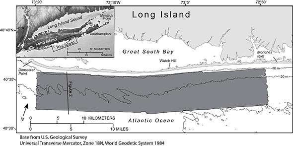
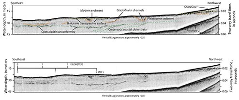
Regional Geologic SettingLong Island marks the southern terminus of the Wisconsinan Laurentide glacial advance in the eastern part of North America (Stone and Borns, 1986). The coast from Southampton to Montauk Point is a headland region where the Ronkonkoma moraine (fig. 1) and associated glacial outwash sediment are eroded directly by wave action (Williams, 1976). The southern shore of Long Island west of Southampton consists of reworked outwash and includes shallow back-barrier bays, marshes, and low-relief, sandy barrier islands (Leatherman and Allen, 1985). Located within this barrier-island system is Fire Island, a 0.5- to 1.0-kilometer (km)-wide, 50-km-long barrier island bounded by two tidal inlets, Moriches Inlet to the east and Fire Island Inlet to the west (fig. 1). Williams (1976) interpreted major inner continental shelf sedimentary sequences offshore of New York by correlating a regional seismic-reflection survey conducted in 1968 with cores, land borings, and exposures. Williams (1976) indicated that Upper Cretaceous-age coastal plain strata on the inner continental shelf south of Long Island are unconformably overlain by Pleistocene sediment, with no preservation of Tertiary-age sedimentary units. Where the coastal plain strata are buried by Quaternary sediment, the regional unconformity between them can be observed in seismic-reflection profiles throughout the New York Bight and on the inner continental shelf south of Long Island (fig. 2; Williams, 1976; Schwab and others, 1997, 2013; Foster and others, 1999). Pleistocene sediments overlying this unconformity are interpreted to be glaciofluvial outwash deposits composed of material ranging from gravel to fine sand that was deposited during the Middle and Late Wisconsinan glacial maximum (Williams, 1976; Schwab and others, 1997, 2013; Foster and others, 1999). These Pleistocene sedimentary deposits characterize much of the inner continental shelf south of Long Island and in places are overlain by modern, reworked sand deposits (Williams, 1976; Foster and others, 1999; Schwab, Thieler, Allen, and others, 2000). The acoustically transparent, Holocene sedimentary deposit on the inner continental shelf offshore of Fire Island consists of relict and modern components. Unpublished vibracore data (U.S Army Corps of Engineers) and sediment grab samples (Schwab, Thieler, Denny, and others, 2000) suggest that some of the paleochannels incising the upper surface of the Pleistocene deposit are filled with a transgressive sequence of glaciofluvial sediment capped by early Holocene muddy estuarine sediment (Schwab, Thieler, Allen, and others, 2000). The modern sediment lies unconformably atop the Pleistocene glaciofluvial and early Holocene channel-fill deposits (fig. 2). This unconformity is interpreted to be the Holocene marine transgressive surface (Foster and others, 1999; Schwab, Thieler, Allen, and others, 2000). The modern sand deposit on the inner continental shelf south of Long Island is derived from erosion of the Cretaceous coastal plain strata and Pleistocene glaciofluvial deposits exposed on the inner continental shelf by oceanographic processes during the Holocene marine transgression; its distribution is discontinuous and variably thick (Williams, 1976; Foster and others, 1999; Schwab, Thieler, Allen, and others, 2000; , Schwab, Thieler, Denny, and others 2000; Schwab and others, 2013). Previous interpretations of marine geophysical data support the hypothesis that the Holocene evolution of Fire Island is directly linked to the geologic framework of the inner continental shelf (Schwab, Thieler, Allen, and others, 2000; Schwab and others, 2013). For example, a relatively large modern sand deposit on the inner continental shelf offshore of western Fire Island is believed to supply the sediment necessary to maintain island stability west of Watch Hill, and this deposit is also a likely source for the historic spit growth observed at Democrat Point and the related modern infilling of Fire Island Inlet (Schwab and others, 2013). |

![]() U.S. Department of the Interior |
U.S. Geological Survey
U.S. Department of the Interior |
U.S. Geological Survey
URL: http://pubsdata.usgs.gov/pubs/of/2014/1203/ofr2014-1203-geologic_setting.html
Page Contact Information: GS Pubs Web Contact
Page Last Modified: Wednesday, 07-Dec-2016 19:39:39 EST