Chapter DWind-Driven Circulation and Sediment Resuspension Processes in Lake Pontchartrain, Louisiana1 USGS Two critical processes related to sediment transport in Lake Pontchartrain are the
resuspension of sediments due to wind- generated storm waves and the transport of
resuspended material during strong wind events. The USGS is studying these processes with
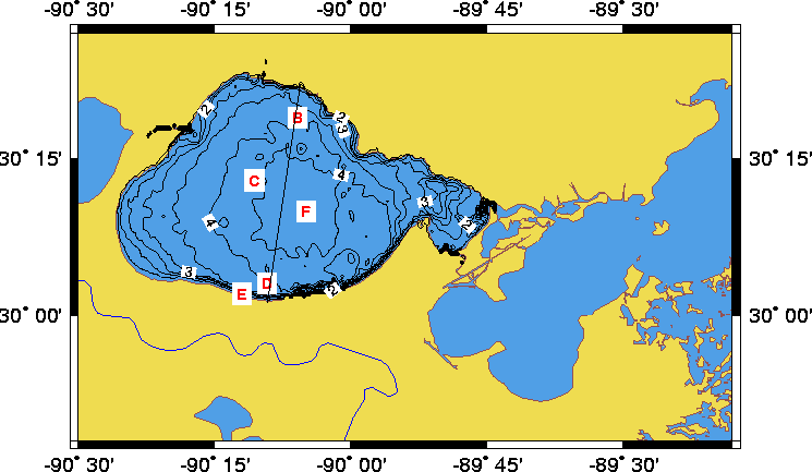
a combination of in- situ data, numerical modeling, and remote sensing. There were two deployments of moored instrumentation, the first in March -June 1995 and the second in January -May 1998 (fig. 1). During the 1995 deployment, continuous wave and turbidity measurements (as well as salinity and temperature) were collected at two depths at each of three sites: north lake, central lake, and south lake. These data indicated that turbidity is highly correlated with bottom currents generated by wind waves (fig. 2). The turbidity at the north and south lake sites showed a directional dependence on the wind, with southerly winds producing larger waves and turbidity at the north lake site, and northerly winds producing larger waves and turbidity at the south lake site, consistent with fetch- limited wave development. The turbidity data also indicate that material resuspended during strong wind- wave events settles rapidly after cessation of wind. Thus, the turbidity is quite nearly in equilibrium with both the wind speed and the wind, the waves lagging the wind by only 2 hours, and the turbidity lagging the waves by only 1 hour.
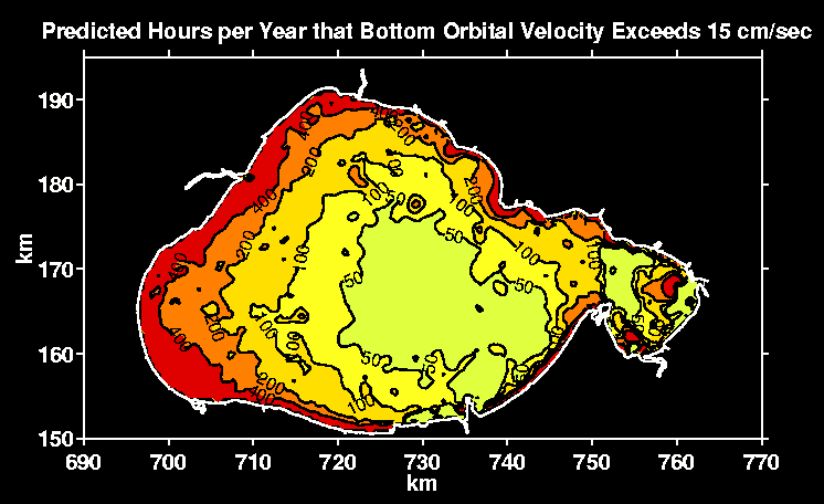
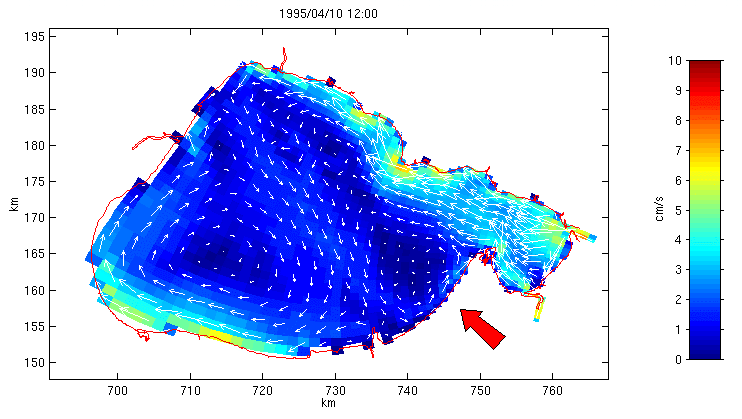
During the 1998 deployment, turbidity, waves, and currents (as well as temperature and salinity) were recorded at two depths at each of two sites in the central and south lake. Initial findings are that the lake does exhibit the double- cell circulation pattern in response to wind that is predicted by the model. Modeling The potential for sediment resuspension was studied using a wave prediction model HISWA (HIndcasting Shallow water WAves, Holthuijsen and others, 1989), which simulates local generation of waves by wind and shallower effects on waves (refraction, shoaling, bottom friction, and breaking). Long-term wind measurements were then used to determine the regional "climate" of bottom orbital velocity: the spatial and temporal variability of wave- induced currents at the bottom (fig. 3). Comparisons of the wave model to the 1995 wave observations were excellent (fig. 4). The circulation of the lake is being studied with the three-dimensional hydrodynamic model of Blumberg and Mellor (1987). Results of this modeling effort indicate that remote forcing due to water levels in Mississippi Sound dominate the circulation near the passes in the eastern end of the lake, while local wind forcing dominates water movement in the western end. As lake levels rise, water enters the lake from the eastern entrances and generates significant westward flows, as much as 10-20 cm/s. Eastward flows are driven by falling lake levels. The model also predicts a two-gyre response driven by winds over the lake, with downwind transport along the periphery of the lake and upwind in the deeper central lake (fig. 5). Thus, during typical storms with winds from the north-northeast or the south-southeast, currents along the south coast near New Orleans generally transport material westward, while material in the central region moves eastward against the wind. The current meter data collected in 1998 will be used to assess the wind response predicted by the circulation model.
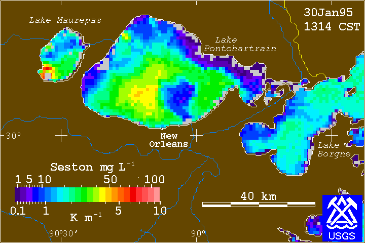
Using 5 years of sea-surface reflectance data as an indicator of turbidity, we hope to determine the relationship between turbidity and bottom stress (predicted from the wave model) throughout the lake and as a function of season. Water property data from the Louisiana Department of Environmental Quality (Dugan Sabans, written commun., 1997), obtained via monthly sampling from the causeway, are being used to ground truth the remotely sensed turbidity.
SELECTED REFERENCES Blumberg, A.F., and Mellor, G.L., 1987, A description of a three-dimensional coastal model, in Heaps, N.S., ed., Three-dimensional coastal ocean models: Washington DC, American Geophysical Union Press, Coastal and Estuarine Series, v. 4, p. 1-16. Holthuijsen, L.H., Booij, N., and Herbers, T.H.C., 1989, A prediction model for stationary, short-crested waves in shallow water with ambient currents: Coastal Engineering, v. 13, p. 23-54. Signell, R.P., and List, J.H., 1997, Modeling waves and circulation in Lake Pontchartrain: Gulf Coast Association of Geological Societies Transactions, v. 47, p. 529-532. Stumpf, R.P., 1998, Satellite imagery of the north-central Gulf of Mexico, June 1993 - May 1997: U.S. Geological Survey Open-File Report 98-484, CD-ROM.
|
||||||||||||||||||||