

Bedrock Fracture Characterization of the New Hampshire State Route 111 Bypass, Windham, New Hampshire
Links
- Document: Report (14.3 MB pdf) , HTML , XML
- Data Release: USGS data release - Fracture data collected at the Route 111 bypass in Windham, New Hampshire
- NGMDB Index Page: National Geologic Map Database Index Page (html)
- Download citation as: RIS | Dublin Core
Acknowledgments
Meghan E. Mason assisted with field data collection when she was a U.S. Geological Survey (USGS) intern while attending Norwich University as an undergraduate student. Ryan J. McAleer (USGS) provided guidance and advise on the scanning electron microscopy. Helpful reviews were provided by Nancy R. Stamm (USGS), Stewart F. Clark Jr. (USGS, retired), and James R. Degnan (USGS). James R. Degnan and Krystle J. Pelham (New Hampshire Department of Transportation) kindly coordinated site access.
Abstract
Bedrock roadcuts developed with blasting along the New Hampshire State Route 111 bypass in Windham expose the metasedimentary Silurian Berwick Formation and intrusions of multiple phases of foliated to nonfoliated granite to granitic pegmatite of the Devonian New Hampshire Plutonic Suite. Fracture characterization at two roadway rock cuts (roadcuts) included measurement of fractures over a distance of approximately 225 and 85 meters. The Berwick Formation consists of medium-gray biotite-plagioclase-quartz granofels, biotite schist, and lesser calc-silicate rock. The Berwick Formation is locally sulfidic. Fresh, unweathered roadcuts are mostly gray but exhibit locally rusty weathering. The most conspicuous foliation in the region around the studied roadcuts is steeply northwest dipping to subvertical and northeast-southwest striking. Regionally, the strike of the foliation is consistently to the northeast-southwest, but the dip is locally variable to both the southeast and northwest. About 8 percent of the observed foliation surfaces exhibit limited fracture parting. The limited degree of parting agrees with observations for rocks within the garnet zone of metamorphism elsewhere in the Windham 7.5-minute quadrangle. The most prominent fracture trend is subvertical to steeply northeast-dipping and northwest-southeast striking (strike and dip of about 295°, 80°). The peak trend of steeply dipping fractures at the two exposures is 295°±12° and 289°±6°. Veins observed in the granite occur parallel to the peak fracture trend and consist primarily of quartz, tourmaline, and ankerite with minor amounts of sulfides (arsenopyrite, galena, and rare sphalerite), and trace amounts of apatite and rutile. The observed peak fracture trend at these roadcuts closely agrees with the most prominent fracture trend recognized within the Windham quadrangle. Gently south- to southeast-dipping and east- to northeast-striking fractures occur as joints and as parting fractures along a weak S3 cleavage. Water-bearing fractures at one exposure occur along joints and gently dipping contacts between the Berwick Formation and the granite to granitic pegmatite of the New Hampshire Plutonic Suite. About 8 percent of the fractures are water-bearing and most water-bearing fractures are gently dipping to the southeast. Fracture data separated by rock type shows a similar distribution for steeply dipping northwest-striking trends, but with much fewer observed steeply north-dipping fractures in the granitic rocks. Both rock types show a cluster of gently south-dipping fractures. The granites show far fewer steeply dipping northeast-striking fractures, which reflects a greater degree of parting along the foliation in the metasedimentary rocks than in the granites. No foliation-parallel fractures were observed in the granites, but some contacts between granites and the Berwick Formation do exhibit parting. Fracture termination classification yields 3 percent abutting, 76 percent dead end, and 21 percent crossing (or throughgoing) fractures.
Six brittle faults were observed, which strike northeast and most dip steeply to the northwest. Calculated paleostress tensors for the faults show an average stress field that is consistent with Late Triassic to Early Jurassic northwest-southeast extension associated with rifting of the New England crust during the initial opening of the Atlantic Basin. Fault data are consistent with brittle reactivation of the northeast striking and northwest dipping dominant foliation.
Introduction
Characterization of brittle fractures in outcrops or roadcuts is an important aspect of hydrogeologic assessments (Caine and Tomusiak, 2003; Manda and Mabee, 2010). Modern geologic maps are useful for this purpose where they contain sufficient brittle fracture data (Walsh and Clark, 1999, 2000).
In rock blasting, explosives create dense, random, radial oriented cracks in the immediate vicinity of boreholes (Kutter and Fairhurst, 1971; McKown, 1986; Fourney, 1993). The fracturing of the rock mass during blasting is influenced by preexisting discontinuities and geologic structure and such features might be extended during blasting but new geologic features are not created in the process (Kutter and Fairhurst, 1971).
Fractures in bedrock play an important role in fractured rock aquifers in crystalline metamorphic rocks because they increase the permeability and porosity of the rock (Caine and Tomusiak, 2003). Fractures in the bedrock near newly blasted roadcuts on Route 111 in Windham, New Hampshire, acted as fluid transport pathways for nitrate contamination from many sources including explosives used in construction of the highway bypass to drinking water wells (Degnan and others, 2016). The lithology and additional observations of mineralogy mapped during this effort also have many implications for water rock reactions affecting groundwater quality (Flanagan and others, 2018). In addition, when some rock types are reduced to rockfill through blasting and are used as roadway construction fill in wet areas, they can contribute to iron fouling of waterways (Lombard and others, 2020).
This report presents the results from a detailed survey of the fractures observed in the roadway rock cuts after blasting but prior to completion of the roadway in June 2014; data are presented in Walsh (2024). Orientation data were measured with an analog pocket transit and entered into the Fieldmove application running on an Apple iPad mini version 2. Coordinates were recorded with a Dual Electronics XPS150 global position system (GPS) receiver linked to the iPad via Bluetooth. Coordinate accuracy is ±5–10 meters (m).
Rock characterization followed traditional geologic mapping practices and findings presented in Walsh and Clark (1999). Fracture characterization followed the approach by Walsh and Clark (2000). The strike and dip of all fractures greater than 20 centimeters (cm) in length (Barton and others, 1993) between the observer's knees and chest were measured on traverses across two roadcuts. Data collected in this manner include all features and have been referred to as “objective” data (Spencer and Kozak, 1976) because there is no sampling bias on the part of the data collector. This most common method is also referred to as the “single scanline method” (Manda and Mabee, 2010). Roadcuts with two different trends were studied to limit directional sampling bias (Terzaghi, 1965; Park and West, 2002), but a statistical correction such as those used in rock mechanic and slope stability studies was not applied (Tang and others, 2018). Locality 1 trends at 80° and locality 2 trends at 30°. Data in Walsh (2024) include coordinate information, unlike traditional scanlines, but further processing or attempts to correct for directional bias are beyond the scope of this study.
Mineral identification was conducted by transmitted light microscopy on standard petrographic thin sections. Semiquantitative mineral identification of one sample of a vein was conducted on a polished slab by energy dispersive X-ray spectroscopy (EDS) on a Hitachi SU5000 scanning electron microscope (SEM) equipped with an Oxford Ultim Max EDS detector and AZtec software. Settings used for SEM analysis were 15 kilovolts (kV) accelerating voltage, 50 intensity (unit specific to Hitachi SEM software that corresponds to ~2.41 nanoampere beam current at 15 kV), and 11.2 millimeters (mm) working distance. Using the AZtec software’s built-in mapping and AutoPhaseMap tools, EDS spectra were collected from each pixel of a 512 x 384 pixel-area at a magnification of 50x (~4.98 microns/pixel). The AutoPhaseMap tool grouped each pixel by similar EDS spectra and assigned a color to each group to create a false color image. The AutoPhaseMap tool was run with a boundary tolerance of 10.0 and a grouping level of 2.0. A polished slab (cut oblique to the vein) was also analyzed using the Feature Analysis tool in AZtec, which collected grayscale backscattered electron image mosaics of large areas, identified features with grayscale values within a user-specified range, and collected EDS spectra from those features specifically. Features were then binned under appropriate mineral names and color coded by comparing their EDS spectra against user-defined criteria (for example, the presence of >5 percent arsenic (As), iron (Fe), and sulfur (S) in the EDS spectrum resulted in binning under the name “arsenopyrite” and coloring the feature orange), resulting in a large-area backscattered electron image with minerals of interest highlighted in color. Each identified feature was confirmed manually to ensure accuracy of mineral identification by the software.
Results
Fracture characterization at two new roadcuts along the New Hampshire Route 111 bypass in Windham, New Hampshire, shows that the outcrops consist of the metasedimentary Berwick Formation intruded by multiple phases of foliated to nonfoliated granite to granitic pegmatite assigned to the New Hampshire Plutonic Suite (Walsh and Clark, 1999, 2000). The Silurian age of the Berwick Formation is constrained by detrital zircon geochronology (Wintsch and others, 2007). The age of the New Hampshire Plutonic Suite is considered Devonian (Zartman and Naylor, 1984; Lyons and others, 1997; Walsh and others, 2013). Post-metamorphic diabase and lamprophyre dikes of the White Mountain Plutonic-Volcanic Suite occur in nearby outcrops (Lyons and others, 1997; Walsh and Clark, 1999), but were not observed at the two localities in this report. Several of the black dikes were observed nearby on the new roadcuts on Interstate 93 (I–93) 0.8 kilometers to the southeast (Walsh, 2024). The dikes were previously exposed at an abandoned quarry (Walsh and Clark, 1999). The mafic dikes are considered Mesozoic age (Foland and Faul, 1977).
On June 10, 2014, bedrock fracture data were collected at two roadcuts in the vicinity of Indian Rock, located west of I–93 and north of Cobbetts Pond (localities 1 and 2, fig. 1). The collection of fracture data followed the objective method employed by Walsh and Clark (2000), including the measurement of fractures over a distance of approximately 225 and 85 m at localities 1 and 2, respectively (fig. 1). Fracture data are available in Walsh (2024).
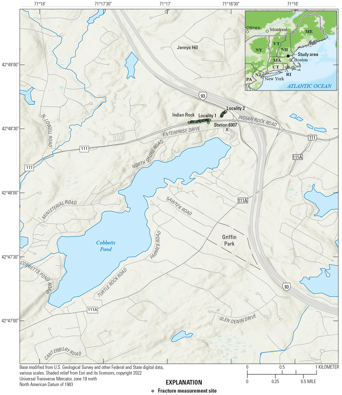
Location map of the Route 111 bypass in Windham, New Hampshire. The inset map (upper right) shows the study area identified with a black dot. Localities 1 and 2 are shown west of I–93 with fracture measurement sites from Walsh (2024) shown by green dots. The location of Station 6007 near the north end of Cobbetts Pond is from Walsh and Clark (2000) and is shown with an X.
The Berwick Formation consists of medium-gray biotite-plagioclase-quartz granofels, biotite schist, and lesser calc-silicate rock. At the two localities, the Berwick Formation consists mostly of granofels. At the time of this study, the Berwick Formation was locally sulfidic, but the fresh, unweathered roadcuts exhibited only locally rusty weathering (10 of 72 fractures at locality 1 are rusty weathering). Abundant masses of light-gray to white, medium- to coarse-grained, muscovite-biotite-quartz-albite-microcline granite and granitic pegmatite occur as foliated irregular masses and crosscutting tabular, weakly foliated and folded dikes. For the purposes of this report, the igneous rocks are simply referred to as “granites.”
The Berwick Formation is polydeformed and locally contains the following four planar fabrics: S0 = bedding, S1 = oldest foliation, S2 = second oldest foliation, and S3 = youngest foliation (Walsh and Clark, 1999). The granites post-date S0 and S1 (Walsh and Clark, 1999). Because the Berwick Formation is largely a granofels, foliation is not readily apparent in many places, especially at the hand-sample scale. Layering of the granofels is apparent at the scale of the roadcuts, however, and the layering is largely tectonic. Two high-strain, locally subparallel, ductile foliations (S1 and S2) are present in the Berwick Formation (Walsh and Clark, 1999), but for the purposes of this fracture study, the two foliations were not considered separately. The most conspicuous planar fabric is a foliation in the area that is steeply northwest dipping to subvertical and northeast-southwest striking (fig. 2). Regionally, the strike of the foliation is consistently to the northeast-southwest, but the dip is locally variable to both the southeast and northwest (Walsh and Clark, 1999). The foliation exhibits limited parting with 9 of 107 fractures (approximately 8 percent) observed parallel to the foliation at the two localities. The limited degree of parting is in agreement with observations from other exposures of the Berwick Formation within the garnet zone elsewhere in the Windham 7.5-minute quadrangle (Walsh and Clark, 2000). Parting fractures along the northeast-striking foliation are more apparent at locality 2 where the data produce a subordinate trend (28°±4°, fig. 3) in the steeply dipping (dip >59°) fracture data. The youngest ductile fabric is a subhorizontal spaced cleavage (S3) with associated symmetrical, low amplitude (5–10 cm) and long wavelength (50–100 cm) folds. This fabric is widespread throughout the area (Walsh and Clark, 1999), but is only visible on vertical exposures due to the shallow dips. This “accordion-like” fabric could be related to a weak D3 vertical-loading event. In the quadrangle, at large quarry and roadcut exposures, the rocks locally exhibit a weak exfoliation parallel to the subhorizontal S3 cleavage. Much of the exfoliation, particularly in the granitic rocks, is most likely related to glacial rebound or post-Mesozoic unroofing, but appears to have utilized the subhorizontal ductile fabric where present.
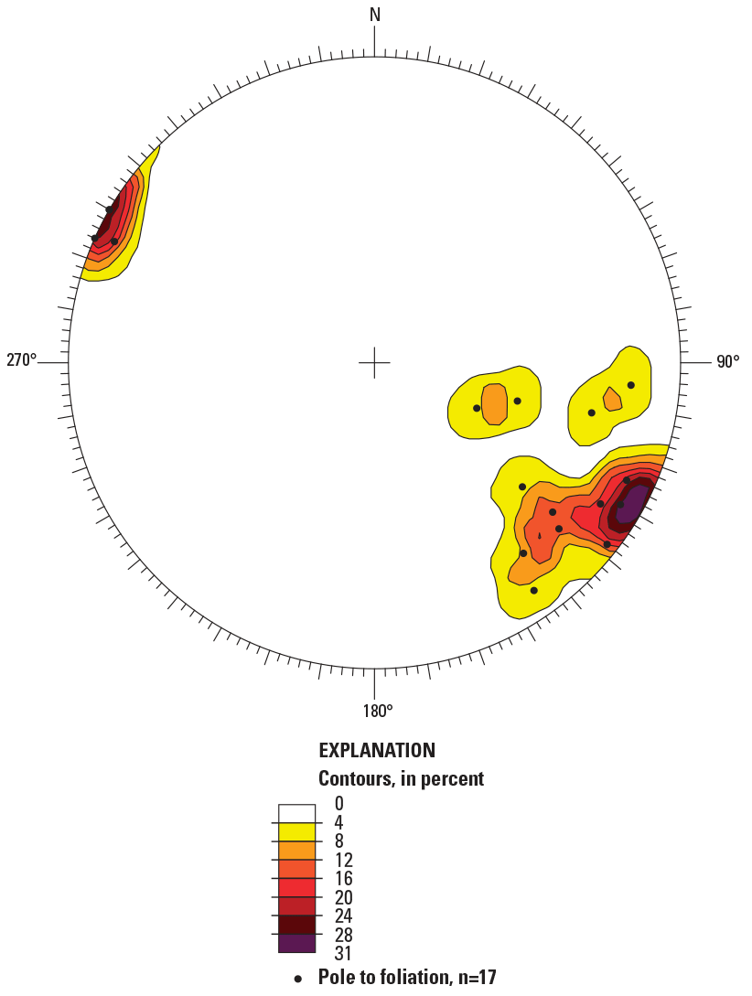
Lower hemisphere equal-area projection (stereonet) of contoured poles to foliation (black dots) within 500 meters of locality 1. Data from Walsh and Clark (1999). “N” indicates north, and “n” is the number of structural measurements in the dataset. Stereonet was plotted using the Daisy 3 software by Salvini (2008).
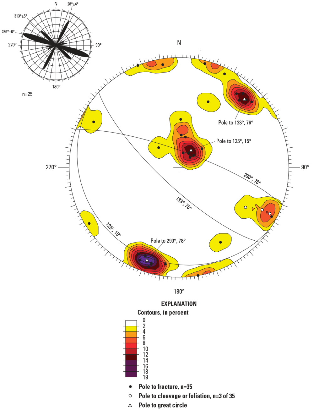
Lower hemisphere equal-area projection (stereonet) of contoured poles to fractures at locality 2. Black dots show poles to fractures, white dots show poles to cleavage or foliation. Great circles show the mean strike and dip of the three principal fracture planes in the data; white triangles show poles to great circles. Inset diagram in the upper left is an azimuth-frequency (rose) diagram of a subset of steeply dipping fractures (dip >59°). “N” indicates north, and “n” is the number of structural measurements in the dataset. Stereonet and rose diagram were plotted using the Daisy 3 software by Salvini (2008).
The most prominent fracture trend is subvertical to steeply northeast-dipping and northwest-southeast striking. Contoured poles to all fractures at each locality show a principal strike and dip of 290°, 78° (locality 2) and 295°, 80° (locality 1) (figs. 3 and 4A). The peak trend of steeply dipping (dip >59°) fractures is 289°±6° (locality 2) and 295°±12° (locality 1) (figs. 3 and 4A). Three fractures with this trend at locality 1 occur along thin (1–3 mm) black veins in granite (fig. 4B). The veins locally show very minor (<1 mm) displacement of mineral grains as microscale fault surfaces or dilation features and were observed in the granite. The veins primarily consist of quartz, tourmaline, and ankerite identified by EDS under a Hitachi SU5000 SEM (fig. 4C–F). Other minerals in the veins include minor amounts of sulfides (identified as arsenopyrite, galena, and rare sphalerite) and apatite. Sulfides were observed in the analyzed vein but not in the host granite. The 289°–295° fracture trend closely agrees with the most prominent fracture trend recognized within the Windham quadrangle, and at the nearby fracture station 6007 (fig. 1) on Indian Rock Road (Walsh and Clark, 2000). Independently, northwest-striking lineaments in the Windham quadrangle show a higher probability of having a high-yielding well nearby indicating that these fractures likely have a higher transmissivity in the fractured bedrock aquifer (Moore and others, 2002).
Gently south- to southeast-dipping and east- to northeast-striking fractures occur as joints and as parting fractures along a weak cleavage (called S3 by Walsh and Clark, 1999, 2000). These gently dipping fractures show a principal strike and dip of 125°, 15° (locality 2) and 17°, 31° (locality 1) (figs. 3 and 4A).
Water-bearing fractures were observed at locality 1 along joints and gently dipping contacts between the Berwick Formation and the granite to granitic pegmatite (figs. 5 and 6). Six of 72 fractures are water-bearing and 4 of the 6 dip gently to the southeast (fig. 4A). A throughgoing, northeast-striking, southeast-dipping water-bearing fracture zone is exposed at locality 1 (fig. 5).
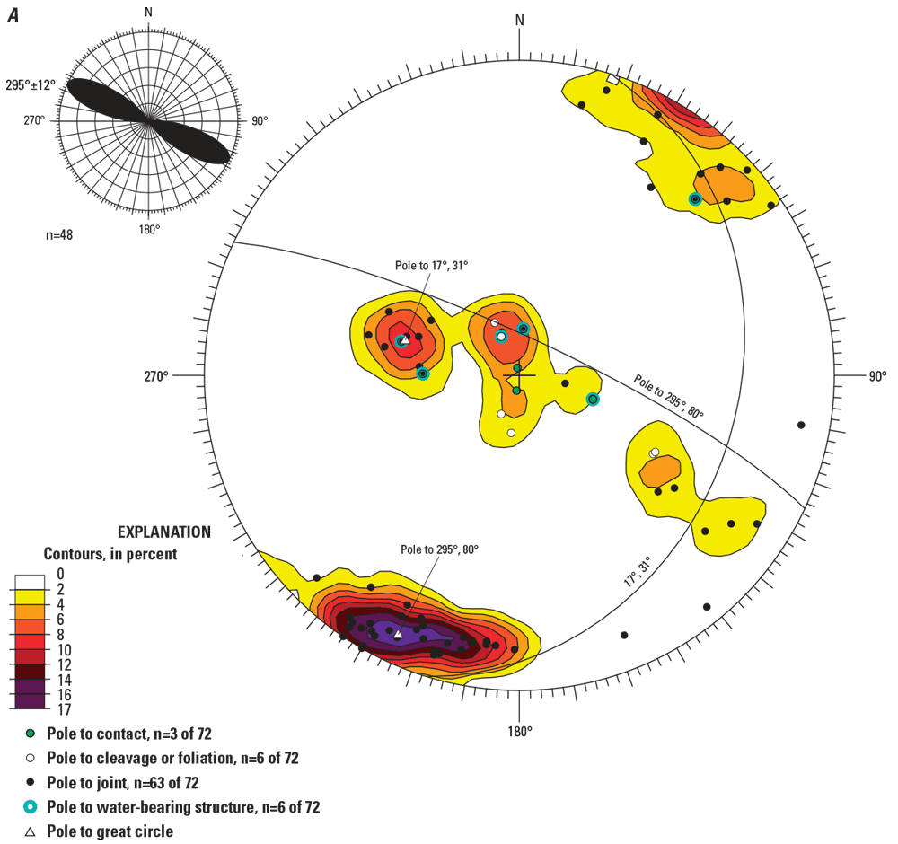
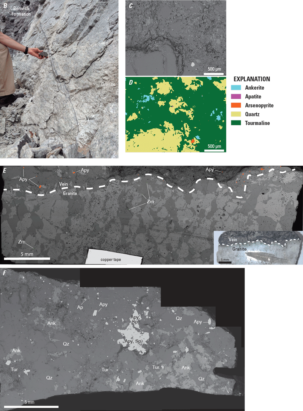
A, Lower hemisphere equal-area projection (stereonet) of contoured poles to fractures at locality 1. Subsets of data include poles to fractures as either joints (black dots) or contacts (green dots); white dots as poles to cleavage or foliation with parting; blue-green open circles as poles to water-bearing structures. Great circles show the mean strike and dip of the two principal fracture planes in the dataset. Inset diagram in the upper left is an azimuth-frequency (rose) diagram of a subset of steeply dipping fractures (dip >59°). “N” indicates north, and “n” is the number of structural measurements in the dataset. Stereonet and rose diagram were plotted using the Daisy 3 software by Salvini (2008). B, Outcrop photograph of black veins primarily consisting of quartz, tourmaline, and ankerite at locality 1 in the granite of the New Hampshire Plutonic Suite. The view is looking northwest, the veins dip steeply northeast. Photograph by Meghan E. Mason, U.S. Geological Survey. C–D, Backscattered electron (BSE) image and false-color scanning electron microscope (SEM) image of a sampled vein showing the main mineral phases that are colored by energy dispersive X-ray spectroscopy (EDS) spectra using the AutoPhaseMap program in Oxford AZtec software. E, BSE image of a block that was cut oblique to the vein. Inset image shows the same block in visible light to highlight the boundary (white dashed line) between the granite and vein. Photograph by Nicholas E. Powell, U.S. Geological Survey. Arsenopyrite (Apy) and zircon (Zrn) were identified by EDS and are colored orange and green, respectively. Note that zircon was identified only in the granite, whereas arsenopyrite was identified only in the vein. F, BSE image of a cut that was made parallel to the sampled vein showing a large arsenopyrite grain plus other mineral phases. Photograph by Nicholas E. Powell, U.S. Geological Survey. Additional abbreviations: Ank, ankerite; Ap, apatite; mm, millimeters; Qz, quartz; Sp, sphalerite; Tur, tourmaline; μm, micron.
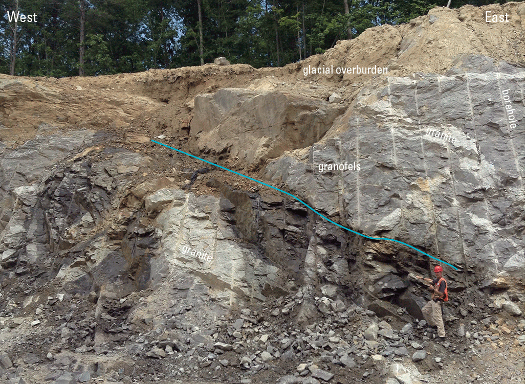
Photograph of part of the roadcut at locality 1 showing gray granofels of the Berwick Formation and white granite of the New Hampshire Plutonic Suite. The view is looking north. The lead author is standing on and pointing along a northeast-striking and southeast-dipping water-bearing fracture zone (highlighted with a blue-green line); the rock is dark gray below the zone because it is wet. Photograph by Meghan E. Mason, U.S. Geological Survey.
For the purposes of this study, fracture data (Walsh, 2024) were divided into generalized rock type including either the Berwick Formation or granite. Fracture data separated by generalized rock type (fig. 7) shows a similar distribution for steeply dipping northwest-striking trends, but with much fewer observed steeply north-dipping fractures in the granitic rocks. Both rock types show a cluster of gently south-dipping fractures. The granites show far fewer steeply dipping northeast-striking fractures, which reflects a greater degree of parting along the foliation in the metasedimentary rocks than in the granites. No foliation-parallel fractures were observed in the granites, but some contacts between granites and the Berwick Formation do exhibit parting (fig. 6).
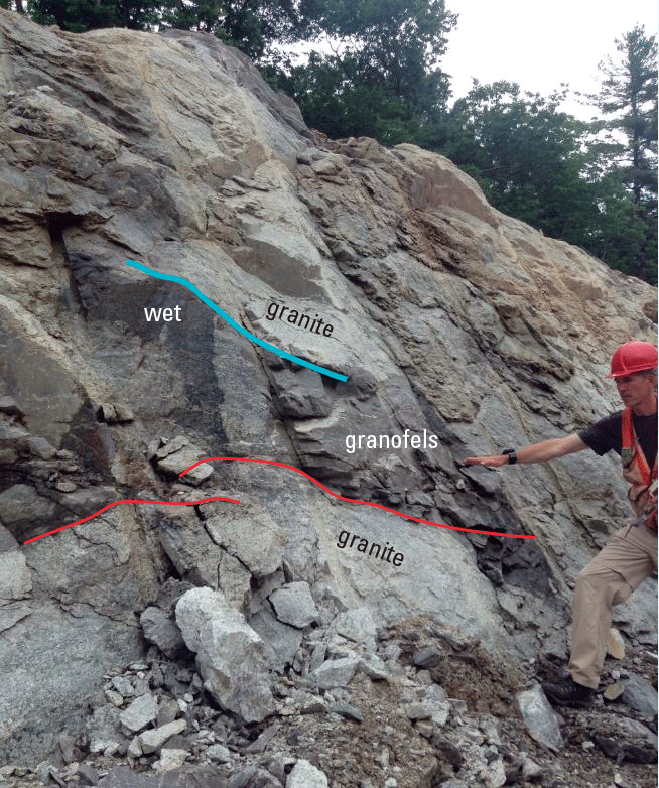
Photograph of part of the roadcut at locality 1 showing gray granofels of the Berwick Formation and white granite of the New Hampshire Plutonic Suite. The view is looking northeast. The blue-green line shows a water-bearing fracture zone along a contact between granite and granofels; the rock is dark gray to the left (below the zone) because it is wet. Parting fractures also occur along the other contacts (red lines) but in this example they are dry. Photograph by Meghan E. Mason, U.S. Geological Survey.
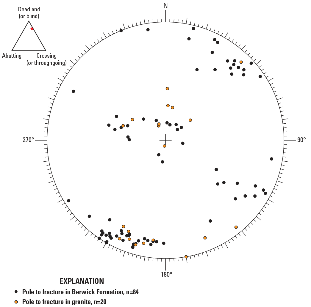
Lower hemisphere equal-area projection (stereonet) of poles to fractures separated by rock type. The ternary diagram (inset, upper left) shows fracture termination classification of Barton and others (1993) for all fractures (see orange star) from localities 1 and 2; fractures are classified as 3 percent abutting, 76 percent dead end (or blind), and 21 percent crossing (or throughgoing). “N” indicates north, and “n” is the number of structural measurements in the dataset. Stereonet was plotted using the Daisy 3 software by Salvini (2008).
Using the fracture termination classification of Barton and others (1993), data from both localities combined yield 3 percent abutting, 76 percent dead end (or blind), and 21 percent crossing (or throughgoing) fractures (fig. 7).
Six brittle faults were observed at localities 1 and 2, and none were water-bearing. The faults strike northeast and most dip steeply to the northwest (fig. 8). Calculated paleostress tensors for the faults (fig. 8) show an average stress field that is consistent with Late Triassic to Early Jurassic northwest-southeast extension associated with rifting of the New England crust during the initial opening of the Atlantic basin (Foland and Faul, 1977; McHone, 1978; Kaye, 1983; McHone and Butler, 1984; de Boer and Clifford, 1988; Manning and de Boer, 1989). Fault data are consistent with brittle reactivation of the northeast-striking and northwest-dipping dominant foliation (compare figs. 2 and 8).
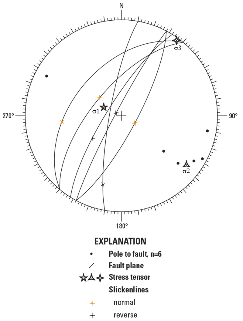
Lower hemisphere equal-area projection (stereonet) showing poles to faults, fault planes, slickenlines, and calculated mean P and T axes for observed normal faults and reverse faults using a Monte Carlo direct inversion approach (for example, Cianfarra and others, 2022). Stress tensors: σ1, maximum principal stress or pressure (“P” axis); σ2, intermediate principal stress; σ3, minimum principal stress or tension (“T” axis). “N” indicates north, and “n” is the number of structural measurements in the dataset. Stereonet was plotted using the Daisy 3 software by Salvini (2008).
References Cited
Barton, C.C., Larsen, E., Page, W.R., and Howard, T.M, 1993, Characterizing fractured rock for fluid-flow, geomechanical, and paleostress modeling—Methods and preliminary results from Yucca Mountain, Nevada: U.S. Geological Survey Open-File Report 93–269, 62 p., 1 pl., accessed November 13, 2024, at https://doi.org/10.3133/ofr93269.
Caine, J.S., and Tomusiak, S.R.A., 2003, Brittle structures and their role in controlling porosity and permeability in a complex Precambrian crystalline-rock aquifer system in the Colorado Rocky Mountain Front Range: Geological Society of America Bulletin, v. 115, no. 11, p, 1410–1424, accessed November 13, 2024, at https://doi.org/10.1130/B25088.1.
Cianfarra, P., Pinheiro, M.R., Villela, F.N.J., and Salvini, F., 2022, Intraplate strike-slip corridor within South America (NE border of the Paraná basin) unveiled by structural analysis of faults and fracture swarms: Geosciences, v. 12, no. 2, 31 p., accessed November 13, 2024, at https://doi.org/10.3390/geosciences12020101.
de Boer, J.Z., and Clifford, A.E., 1988, Mesozoic tectogenesis—Development and deformation of “Newark” rift zones in the Appalachians (with special emphasis on the Hartford basin, Connecticut), chap. 11 of Manspeizer, W., ed., Triassic-Jurassic rifting—Continental breakup and the origin of the Atlantic Ocean and passive margins: Developments in Geotectonics, v. 22, pt. A, p. 275–306. [Also available at https://doi.org/10.1016/B978-0-444-42903-2.50016-6.]
Degnan, J.R., Bohlke, J.K., Pelham, K., Langlais, D.M., and Walsh, G.J., 2016, Identification of groundwater nitrate contamination from explosives used in road construction—Isotopic, chemical, and hydrologic evidence: Environmental Science & Technology, v. 50, no. 2, p. 593–603, accessed July 13, 2016, at https://doi.org/10.1021/acs.est.5b03671.
Flanagan, S.M., Ayotte, J.D., and Robinson, G.R., Jr., 2018, Quality of water from crystalline rock aquifers in New England, New Jersey, and New York, 1995–2007 (ver. 1.1, April 2018): U.S. Geological Survey Scientific Investigations Report 2011–5220, 104 p., accessed November 13, 2024, at https://doi.org/10.3133/sir20115220.
Foland, K.A., and Faul, H., 1977, Ages of the White Mountain intrusives—New Hampshire, Vermont, and Maine, USA: American Journal of Science, v. 277, no. 7, p. 888–904. [Also available at https://doi.org/10.2475/ajs.277.7.888.]
Kaye, C.A., 1983, Discovery of a Late Triassic basin north of Boston and some implications as to post-Paleozoic tectonics in northeastern Massachusetts: American Journal of Science, v. 283, no. 10, p. 1060–1079. [Also available at https://ajsonline.org/article/60269.]
Kutter, H.K., and Fairhurst, C., 1971, On the fracture process in blasting: International Journal of Rock Mechanics and Mining Sciences & Geomechanics Abstracts, v. 8, no. 3, p. 181–202. [Also available at https://doi.org/10.1016/0148-9062(71)90018-0.]
Lombard, M.A., Lombard, P.J., Brown, C.J., and Degnan, J.R., 2020, A multi-model approach toward understanding iron fouling at rock-fill drainage sites along roadways in New Hampshire, USA: SN Applied Sciences, v. 2, no. 1073, 16 p., accessed January 2, 2025, at https://doi.org/10.1007/s42452-020-2849-2.
Lyons, J.B., Bothner, W.A., Moench, R.H., and Thompson, J.B., Jr., 1997, Bedrock geologic map of New Hampshire: U.S. Geological Survey, 2 sheets, scale 1:250,000. [Also available at https://ngmdb.usgs.gov/Prodesc/proddesc_37338.htm.]
Manda, A.K., and Mabee, S.M., 2010, Comparison of three fracture sampling methods for layered rocks: International Journal of Rock Mechanics and Mining Sciences, v. 47, no. 2, p. 218–226, accessed March 11, 2010, at https://doi.org/10.1016/j.ijrmms.2009.12.004.
Manning, A.H., and de Boer, J.Z., 1989, Deformation of Mesozoic dikes in New England: Geology, v. 17, no. 11, p. 1016–1019. [Also available at https://doi.org/10.1130/0091-7613(1989)017<1016:DOMDIN>2.3.CO;2.]
McHone, J.G., 1978, Distribution, orientations, and ages of mafic dikes in central New England: Geological Society of America Bulletin, v. 89, no. 11, p. 1645–1655. [Also available at https://doi.org/10.1130/0016-7606(1978)89<1645:DOAAOM>2.0.CO;2.]
McHone, J.G., and Butler, J.R., 1984, Mesozoic igneous provinces of New England and the opening of the North Atlantic Ocean: Geological Society of America Bulletin, v. 95, no. 7, p. 757–765. [Also available at https://doi.org/10.1130/0016-7606(1984)95<757:MIPONE>2.0.CO;2.]
McKown, A.F., 1986, Perimeter control blasting for underground excavations in fractured and weathered rock: Environmental & Engineering Geoscience, v. 23, no. 4, p. 461–478, accessed January 3, 2025, at https://doi.org/10.2113/gseegeosci.xxiii.4.461.
Moore, R.B., Schwarz, G.E., Clark, S.F., Jr., Walsh, G.J., and Degnan, J.R., 2002, Factors related to well yield in the fractured-bedrock aquifer of New Hampshire: U.S. Geological Survey Professional Paper 1660, 51 p., 2 pls., accessed March 10, 2010, at https://pubs.usgs.gov/pp/pp1660/.
Park, H.J., and West, T.R., 2002, Sampling bias of discontinuity orientation caused by linear sampling technique: Engineering Geology, v. 66, nos. 1–2, p. 99–110, accessed November 15, 2024, at https://doi.org/10.1016/S0013-7952(02)00034-0.
Spencer, E.W., and Kozak, S.J., 1976, Determination of regional fracture patterns in Precambrian rocks—A comparison of techniques, chap. 11 of Hodgson, R.A., Gay, S.P., Jr., and Benjamins, J.Y., eds., Proceedings of the First International Conference on the New Basement Tectonics, Salt Lake City, Utah, June 3–7, 1974: Salt Lake City, Utah, Utah Geological Association Publication No. 5, p. 409–415. [Also available at https://archives.datapages.com/data/uga/data/091/091001/409_ugs0910409.htm.]
Tang, H., Zhang, J., Huang, L., Yan, C., Hu, S., and Ez Eldin, M.A.M., 2018, Correction of line-sampling bias of rock discontinuity orientations using a modified Terzaghi method: Advances in Civil Engineering, v. 2018, article no. 1629039, 9 p., accessed January 2, 2025, at https://doi.org/10.1155/2018/1629039.
Terzaghi, R.D., 1965, Source of error in joint surveys: Géotechnique, v. 15, no. 3, p. 287–304, accessed January 2, 2025, at https://doi.org/10.1680/geot.1965.15.3.287.
Walsh, G.J., 2024, Fracture data collected at the Route 111 bypass in Windham, New Hampshire: U.S. Geological Survey data release, accessed December 20, 2024, at https://doi.org/10.5066/P14A6TJY.
Walsh, G.J., and Clark, S.F., Jr., 1999, Bedrock geologic map of the Windham quadrangle, Rockingham and Hillsborough Counties, New Hampshire (ver. 1.1): U.S. Geological Survey Open-File Report 99–8, 18-p. text, 1 sheet, scale 1:24,000. [Also available at https://pubs.usgs.gov/of/1999/of99-8/.]
Walsh, G.J., and Clark, S.F., Jr., 2000, Contrasting methods of fracture trend characterization in crystalline metamorphic and igneous rocks of the Windham quadrangle, New Hampshire: Northeastern Geology and Environmental Sciences, v. 22, no. 2, p. 109–120. [Also available at https://www.researchgate.net/publication/289187405_Contrasting_methods_of_fracture_trend_characterization_in_crystalline_metamorphic_and_igneous_rocks _of_the_Windham_quadrangle_New_Hampshire.]
Walsh, G.J., Jahns, R.H., and Aleinikoff, J.N., 2013, Bedrock geologic map of the Nashua South quadrangle, Hillsborough County, New Hampshire, and Middlesex County, Massachusetts: U.S. Geological Survey Scientific Investigations Map 3200, 31-p. pamphlet, 1 sheet, scale 1:24,000. [Also available at https://doi.org/10.3133/sim3200.]
Wintsch, R.P., Aleinikoff, J.N., Walsh, G.J., Bothner, W.A., Hussey, A.M., and Fanning, C.M., 2007, SHRIMP U-Pb evidence for a late Silurian age of metasedimentary rocks in the Merrimack and Putnam-Nashoba terranes, eastern New England: American Journal of Science, v. 307, no. 1, p. 119–167. [Also available at https://doi.org/10.2475/01.2007.05.]
Zartman, R.E., and Naylor, R.S., 1984, Structural implications of some radiometric ages of igneous rocks in southeastern New England: Geological Society of America Bulletin, v. 95, no. 5, p. 522–539. [Also available at https://doi.org/10.1130/0016-7606(1984)95<522:SIOSRA>2.0.CO;2.]
Abbreviations
%
percent
Ank
ankerite
Ap
apatite
Apy
arsenopyrite
As
arsenic
BSE
backscattered electron
cm
centimeter
EDS
energy dispersive X-ray spectroscopy
Fe
iron
ft
foot
kV
kilovolt
m
meter
mm
millimeter
N
north
n
number of points in dataset
Qz
quartz
S
sulfur
S0
bedding
S1
oldest foliation
S2
second oldest foliation
S3
youngest foliation
SEM
scanning electron microscope
Sp
sphalerite
Tur
tourmaline
μm
micron
USGS
U.S. Geological Survey
Zrn
zircon
For additional information regarding this publication, contact:
Director, USGS Florence Bascom Geoscience Center
12201 Sunrise Valley Drive, MS 926A
Reston, VA 20192
Or visit USGS Florence Bascom Geoscience Center at
https://www.usgs.gov/centers/florence-bascom-geoscience-center.
Prepared by the USGS Science Publishing Network
Reston Publishing Service Center
Edited by David A. Shields
Illustration and layout support by Jeffrey L. Corbett
Disclaimers
Any use of trade, firm, or product names is for descriptive purposes only and does not imply endorsement by the U.S. Government.
Although this information product, for the most part, is in the public domain, it also may contain copyrighted materials as noted in the text. Permission to reproduce copyrighted items must be secured from the copyright owner.
Suggested Citation
Walsh, G.J., and Powell, N.E., 2025, Bedrock fracture characterization of the New Hampshire State Route 111 bypass, Windham, New Hampshire: U.S. Geological Survey Data Report 1208, 12 p., https://doi.org/10.3133/dr1208.
ISSN: 2771-9448 (online)
Study Area
| Publication type | Report |
|---|---|
| Publication Subtype | USGS Numbered Series |
| Title | Bedrock fracture characterization of the New Hampshire State Route 111 bypass, Windham, New Hampshire |
| Series title | Data Report |
| Series number | 1208 |
| DOI | 10.3133/dr1208 |
| Publication Date | March 03, 2025 |
| Year Published | 2025 |
| Language | English |
| Publisher | U.S. Geological Survey |
| Publisher location | Reston, VA |
| Contributing office(s) | Florence Bascom Geoscience Center |
| Description | Report: vi, 12 p.; Data Release |
| Country | United States |
| State | New Hampshire |
| City | Windham |
| Online Only (Y/N) | Y |
| Additional Online Files (Y/N) | N |