

Minnesota and Landsat
Links
- Document: Report (5.14 MB pdf) , HTML , XML
- Version History: Version History (5 KB txt)
- NGMDB Index Page: National Geologic Map Database Index Page (html)
- Download citation as: RIS | Dublin Core
Abstract
Minnesota, the “Land of 10,000 Lakes,” treasures the beauty of its natural environment. The State is also home to a wide range of agriculture, manufacturing, tourism, and natural resource industries. Minnesotans understand the need to grow their economy and manage their resources in an environmentally sustainable manner.
Landsat land-imaging satellites underpin public and private sector decisions in the State and across the Nation for effective adaptation to changing landscapes. Those decisions often lead to enhanced agricultural productivity, smart urban development, and sustainable forest management. Landsat also enables more accurate inland lake water-quality monitoring, increased disaster resilience and risk assessment, effective water use, more-informed climate research, and other applications. Here are several examples for the State of Minnesota.
Smart Urban Development
The Twin Cities of Minneapolis and St. Paul are home to about 54 percent of Minnesota’s population. Municipal authorities must balance continued economic development and the resulting urban growth to maintain harmony with the surrounding environment. Landsat sensors are ideally suited for detecting the effect people have on the surrounding landscape. For cities, that translates into the monitoring of urban sprawl and land-use efficiency, measuring impervious surface area (for example, buildings, roads, and parking lots), observing heat island effects, and linking urban growth and rainfall pattern change.
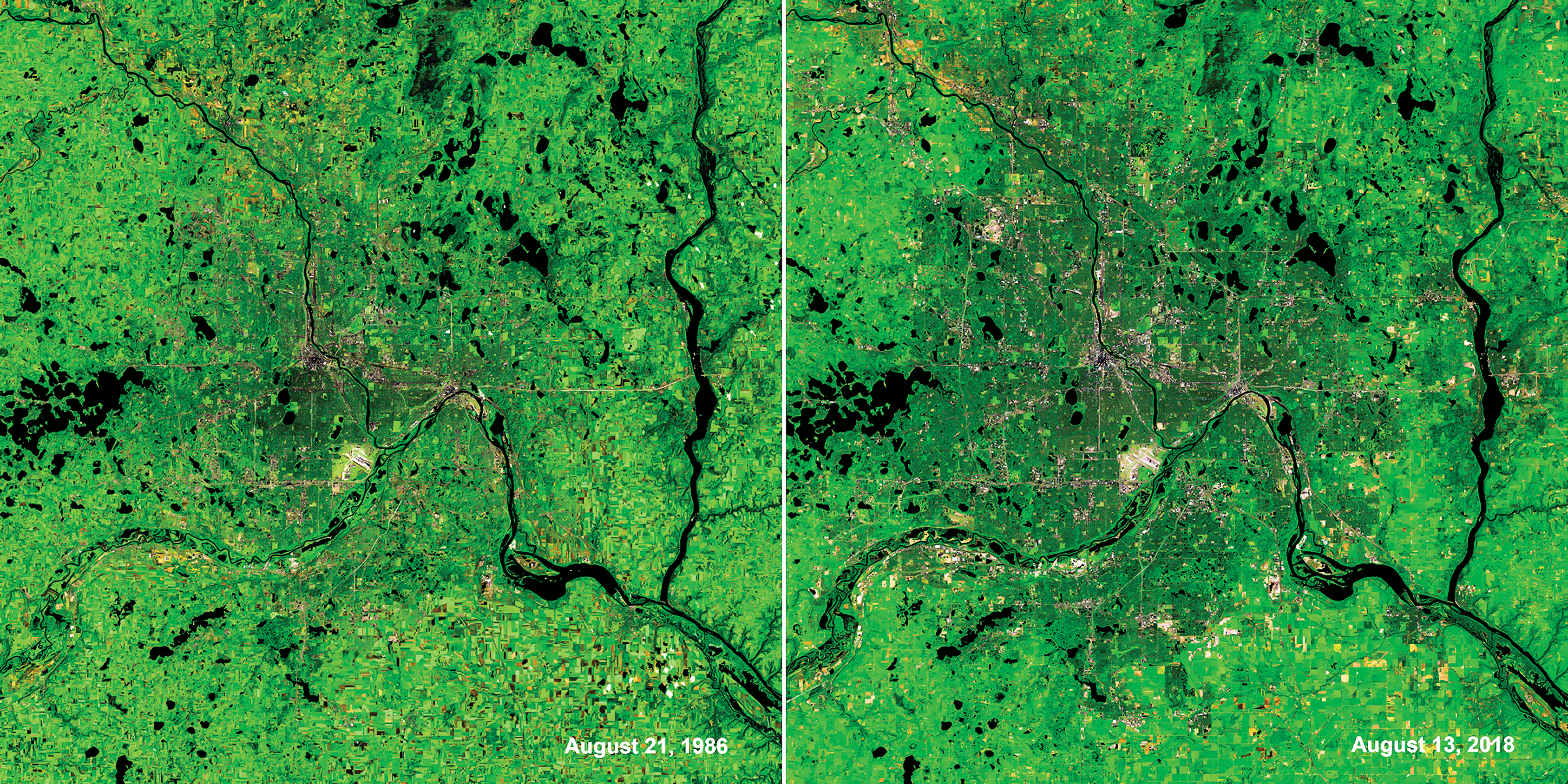
Urban and suburban growth in the Twin Cities area over the past 32 years. The image on the left is from August 1986, and the image on the right is from August 2018. Image credits: U.S. Geological Survey.
Water-Quality Monitoring
Minnesota’s numerous inland lakes are sources of pride, respite, and recreation for its citizens. State and local authorities need to protect lakes’ water quality for recreational, consumptive, and environmental purposes. With so many lakes across so broad an area, it has proven impossible to assess even a small fraction of them through conventional field methods. The use of Landsat is a cost-effective way to gather the information needed for regional water-quality assessments. Using Landsat, researchers at the University of Minnesota were able to classify the water clarity of more than 10,000 lakes in the State. Knowledge gained from this work can inform local authorities’ water management and remediation efforts (University of Minnesota, 2022).
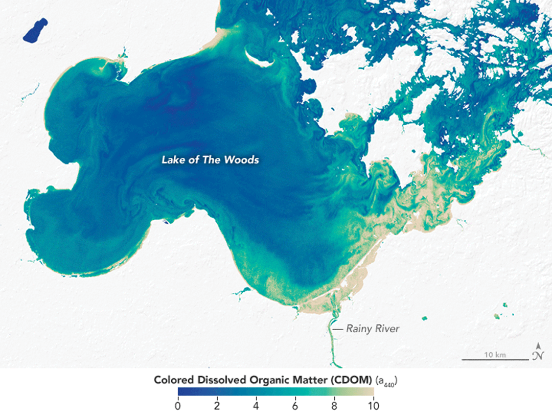
Colored dissolved organic matter in Minnesota’s Lake of the Woods. Image credit: NASA.
Precision Agriculture
Landsat data help farmers to make decisions on optimal livestock rotation, understand current crop conditions, and vary their application of fertilizer and seed. AWG Farms in Minnesota has used Landsat imagery to monitor vegetation health in its beet fields since 1997. With this knowledge, farmers can adjust nitrogen levels using global positioning system-enabled variable fertilizer application, saving 60–70 pounds of nitrogen per acre and minimizing environmental impact from nutrient runoff and leaching caused by overapplication of fertilizer (Anjozian, 2012).

Landsat 5 imagery of a sugar beet field collected July 13, 2005, shows a true color composite (left), color infrared (center), and near-infrared band (right) processed to show vegetation status related to nitrogen. Photograph credit: Gary Wagner, AWG Farms; used with permission.
National Land Imaging Program Benefits—Minnesota
The U.S. Geological Survey (USGS) National Land Imaging Program provides a wide range of satellite imagery and other remotely sensed and geospatial data to Government, commercial, academic, and public users. Those users can get worldwide access to Landsat satellite data through the National Land Imaging Program-funded USGS Earth Resources Observation and Science (EROS) Center.
Landsat—Critical Information Infrastructure for the Nation
Landsat is the most widely used land remote sensing data source within Federal civilian agencies. Local, State, Tribal, and Federal agencies use Landsat to monitor and forecast a wide range of land surface phenomena. Information from Landsat contributes to day-to-day decisions on land, water, and resource use that protect life and property; safeguard the environment; advance science, technology, and education; support climate change resiliency; and grow the U.S. economy. Landsat’s imagery provides a landscape-level view of land surface, inland lake, and coastal processes, both natural and human-induced. Landsat enables us to better understand the scope, nature, and speed of change to the natural and built environment.
Businesses draw upon Landsat data to provide customer-specific applications to improve logistics, resource allocation, and investment decisions. Commercial space imaging firms leverage Landsat data to refine product offerings and support new information services. A 2017 USGS study determined the total annual economic benefit of Landsat data in the United States. to be $2.06 billion, far surpassing its development and operating costs (Straub and others, 2019).
Landsat 8 and Landsat 9 provide 8-day repeat coverage of the Earth’s land surfaces. The National Aeronautics and Space Administration (NASA) and the USGS are currently reviewing the findings from a joint Architecture Study Team, which will inform the design and implementation approach for Landsat Next, the follow-on mission to Landsat 9. Landsat 9 and its successors are planned to provide a sustainable, space-based system to extend the 50-year Landsat series of high-quality global land imaging measurements—the world’s longest time series of the Earth’s land surface.
The long-term availability of consistent and accurate Landsat data, combined with a no-cost data policy, allows users to analyze extensive geographic areas and better understand and manage long-term trends in land surface change. New cloud computing and data analytics technologies use Landsat data in a wide range of decision-support tools for Government and industry. Much like global positioning systems and weather data, Landsat data are used every day to help us better understand our dynamic planet.
References Cited
Anjozian, L., 2012, Landsat satellites find the “sweet spot” for crops: National Aeronautics and Space Administration web page, accessed September 14, 2022, at https://www.nasa.gov/mission_pages/landsat/news/sweet-spot.html.
Straub, C.L., Koontz, S.R., and Loomis, J.B., 2019, Economic valuation of Landsat imagery: U.S. Geological Survey Open-File Report 2019–1112, 13 p., accessed September 14, 2022, at https://doi.org/10.3133/ofr20191112.
University of Minnesota, 2022, Lake water clarity—Minnesota statewide: University of Minnesota web page, accessed September 14, 2022, at https://water.rs.umn.edu/lwc/water-clarity.
For additional information on Landsat, please contact:
Program Coordinator
USGS National Land Imaging Program
12201 Sunrise Valley Drive
Reston, VA 20192
703–648–5953
The Landsat series is a joint effort of the USGS and NASA. NASA develops and launches the spacecraft; the USGS manages satellite operations, ground reception, data archiving, product generation, and data distribution. Funding for the National Land Imaging Program’s Landsat operations and data management is provided through the USGS.
Disclaimers
Any use of trade, firm, or product names is for descriptive purposes only and does not imply endorsement by the U.S. Government.
Although this information product, for the most part, is in the public domain, it also may contain copyrighted materials as noted in the text. Permission to reproduce copyrighted items must be secured from the copyright owner.
Suggested Citation
U.S. Geological Survey, 2020, Minnesota and Landsat (ver. 1.2, November 2024): U.S. Geological Survey Fact Sheet 2020–3059, 2 p., https://doi.org/10.3133/fs20203059.
ISSN: 2327-6932 (online)
ISSN: 2327-6916 (print)
Study Area
| Publication type | Report |
|---|---|
| Publication Subtype | USGS Numbered Series |
| Title | Minnesota and Landsat |
| Series title | Fact Sheet |
| Series number | 2020-3059 |
| DOI | 10.3133/fs20203059 |
| Edition | Version 1.0: December 21, 2020; Version 1.1: October 17, 2022; Version 1.2: November 26, 2024 |
| Publication Date | December 21, 2020 |
| Year Published | 2020 |
| Language | English |
| Publisher | U.S. Geological Survey |
| Publisher location | Reston, VA |
| Contributing office(s) | Earth Resources Observation and Science (EROS) Center |
| Description | 2 p. |
| Country | United States |
| State | Minnesota |
| Online Only (Y/N) | N |
| Additional Online Files (Y/N) | Y |