

Help Build the Protected Areas Database of the United States (PAD-US)
Links
- Document: Report (4.95 MB pdf) , HTML , XML
- Related Work: Protected Areas Resources
- Data Release: USGS data release - Protected Areas Database of the United States (PAD-US) 3.0 (ver. 2.0, March 2023)
- Download citation as: RIS | Dublin Core
Abstract
PAD-US is the Nation’s official inventory of areas dedicated to the preservation of biological diversity and to other natural, recreational, and cultural uses, and is managed for these purposes through legal or other effective means.
What is PAD-US?
PAD-US provides a comprehensive geospatial database of protected and managed areas in the United States (fig. 1). We assemble known protected areas whose primary purpose is biodiversity conservation, as well as lands and waters that provide public access to nature. As a National Geospatial Data Asset (https://ngda-portfolio-community-geoplatform.hub.arcgis.com/), the PAD-US database (https://www.usgs.gov/programs/gap-analysis-project/science/protected-areas) is an aggregation of land and water management boundaries provided by authoritative sources and standardized into a common format.
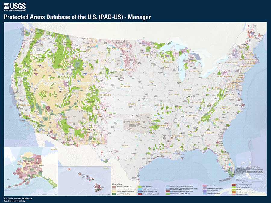
Example of the Protected Area Database of the United States (PAD-US) National Poster Map. The full-size and most up-to-date version of this map can be found at https://www.usgs.gov/programs/gap-analysis-project/science/protected-areas-resources.
Who helps build PAD-US?
PAD-US is managed by the U.S. Geological Survey (USGS; USGS, 2022), but it takes many partners to create this database. Our large collaborator network includes Federal, State, and nongovernmental organizations (NGO) whose work is closely aligned with PAD-US goals.
Federal data stewards coordinate through the Federal Geographic Data Committee (FGDC) Federal Lands Workgroup (FLWG) and include geospatial professionals from Federal land management agencies and other Federal stakeholders. Federal land management agencies are the authoritative source of Federal protected areas data in PAD-US.
State and local data stewards coordinate through the State Land Working Group (SLWG) and include representatives from State government agencies, local governments, universities, and NGO. State data-stewards provide State lands data and local government and private lands data.
NGO also work closely with PAD-US to contribute data for privately-owned protected areas and easements, as well as some data for local park areas.
For more information, see our Data Stewards overview (https://www.usgs.gov/programs/gap-analysis-project/science/pad-us-data-stewards#overview).
How are PAD-US data used?
By giving the American public a detailed accounting of shared investments, PAD-US makes it possible to inform decisions related to biodiversity conservation, climate, outdoor recreation, resource management, public health, and emergency response, including wildland fire coordination. Data contributors also benefit from using PAD-US data to inform their agency’s decisions.
PAD-US provides summary statistics of areas managed for biodiversity protection and for public access for the entire nation as well as by State, county, Department of the Interior Region, Congressional District, ecoregions, and other geographic units. PAD-US provides key data components that support national initiatives like America the Beautiful (https://www.doi.gov/priorities/america-the-beautiful) and the American Conservation and Stewardship Atlas.
PAD-US Vision
PAD-US aims to assemble known protected areas that have a primary purpose of biodiversity conservation, as well as lands and waters that provide public access to nature. Moving forward, USGS is interested in working with Tribal communities to appropriately represent protected areas in the lands and waters of these Tribal nations.
PAD-US will continue collaborating with Mexico and Canada to map protected areas in North America. This will be accomplished through collaboration with the North America Intergovernmental Committee on Cooperation for Wilderness and Protected Areas Conservation (NAWPA; https://nawpacommittee.org/). PAD-US also collaborates with United Nations Environment Programme World Conservation Monitoring Centre (UNEP-WCMC; https://www.unep-wcmc.org/en) to submit United States protected areas data for inclusion in the World Database of Protected Areas (WDPA; https://www.protectedplanet.net/en/thematic-areas/wdpa?tab=WDPA).
Goals for 2023–2025
-
• Engage more State data stewards to provide protected areas data for their States and make the data more complete and useful to everyone, including all the data contributors.
-
• Provide regular communication, coordination, and assistance for State data stewards, resulting in more frequent updates from all 50 States and territories.
-
• Release annual updates of Federal protected areas. This depends on our network of Federal data stewards who contribute data annually.
Get ready to submit your data!
USGS develops information and tools to assist stewards with the data submission process. Several resources like a PAD-US Data Manual are available on USGS’s website to provide stewards with requirements necessary for successful data integration into PAD-US.
Contact the PAD-US Team (pad-us@usgs.gov) for additional guidance.
“Wyoming Geographic Information Science Center (WyGISC) uses PAD-US in an online application addressing cutthroat trout conservation. This application allows state resource managers to better understand the health and conservation needs for the species. In particular, WyGISC is able to use PAD-US to analyze land ownership boundaries with the species’ historic and current ranges without having to collect boundary data from multiple sources.”
- Jason Writer, Geospatial Developer I at WyGISC
References Cited
U.S. Geological Survey [USGS] Gap Analysis Project [GAP], 2022, Protected Areas Database of the United States (PAD-US) 3.0: U.S. Geological Survey data release, https://doi.org/10.5066/P9Q9LQ4B.
Disclaimers
Any use of trade, firm, or product names is for descriptive purposes only and does not imply endorsement by the U.S. Government.
Although this information product, for the most part, is in the public domain, it also may contain copyrighted materials as noted in the text. Permission to reproduce copyrighted items must be secured from the copyright owner.
Suggested Citation
U.S. Geological Survey, 2023, Help build the Protected Areas Database of the United States (PAD-US): U.S. Geological Survey Fact Sheet 2023–3013, 2 p., https://doi.org/10.3133/fs20233013.
ISSN: 2327-6932 (online)
ISSN: 2327-6916 (print)
Study Area
| Publication type | Report |
|---|---|
| Publication Subtype | USGS Numbered Series |
| Title | Help build the Protected Areas Database of the United States (PAD-US) |
| Series title | Fact Sheet |
| Series number | 2023-3013 |
| DOI | 10.3133/fs20233013 |
| Publication Date | April 17, 2023 |
| Year Published | 2023 |
| Language | English |
| Publisher | U.S. Geological Survey |
| Publisher location | Reston, VA |
| Contributing office(s) | Science Analytics and Synthesis |
| Description | Report: 2 p.; Data Release |
| Country | United States |
| Online Only (Y/N) | N |