

U.S. Geological Survey Rocky Mountain Region 2022 Science Exchange, Showcasing Interdisciplinary and State-of-the-Art USGS Science
Links
- Document: Report (4.83 MB pdf) , HTML , XML
- Download citation as: RIS | Dublin Core
Interdisciplinary Science as a Tool for Policy Making and Product Development
Addressing the complex problems inherent to interactions between natural systems and humans, as well as the fast-paced policy decisions needed to resolve them, requires interdisciplinary approaches and incorporation of emerging technologies and methods. For example, a holistic understanding of river systems that sustain the Western United States necessitates interdisciplinary knowledge of hydrology, geochemistry, water quality, geomorphology, and ecology coupled with technologies including remote sensing, spatial and temporal modeling, and sophisticated ground-based monitoring methods. This diverse set of knowledge and skills contributes to a comprehensive understanding of how and why these systems change over time and provides useful data for designing optimal strategies and promoting the adaptive capacity of these systems. USGS scientific efforts in the Rocky Mountains and associated basins, including the Colorado River Basin, illustrate how interdisciplinary approaches improve scientific understanding, address the multiple needs of stakeholders, and inform management decisions in a timely manner.
On the first day of the Science Exchange, keynote speakers called for interdisciplinary science to be part of the fabric of USGS science practices. USGS managers recognize that cultural and structural changes at the organizational level are required to enable development and successful implementation of interdisciplinary science projects, making them as familiar to design and manage as single-discipline projects. Speakers also emphasized the need for USGS science to be readily used by managers and policy makers and introduced the “Participatory Science” model (fig. 1A) in which scientists and stakeholders work together to design projects and develop relevant products, based on co-production of science with external partners and other bureaus in the Department of the Interior. Speakers built upon the idea of co-production through the discussion of interdisciplinary science (fig. 1B). By involving other disciplines in USGS work, including social sciences, urban planning, and Indigenous and community knowledge, the USGS can better translate its work to policy makers and resource managers, resulting in the development of useful products and analytical tools for communities who need them.
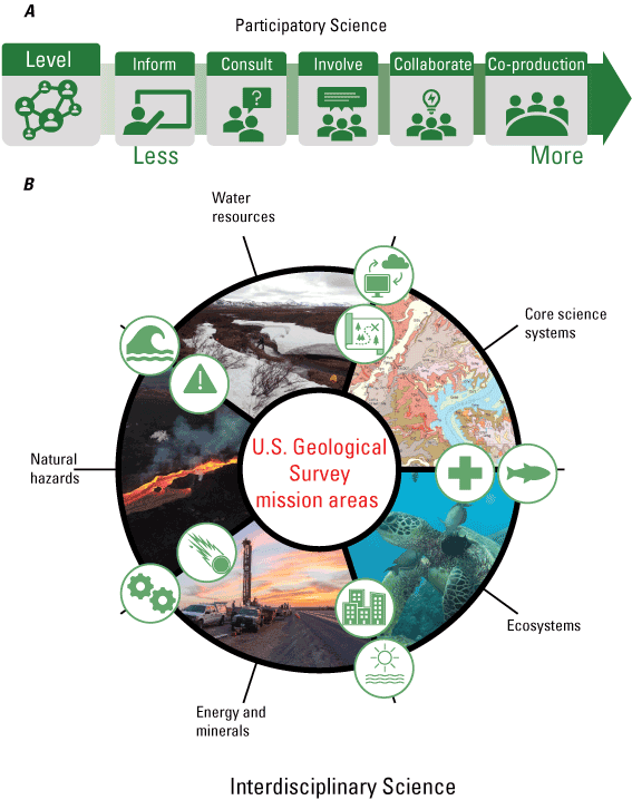
A) The model of participatory science involves a shift from informational to co-produced scientific results. This process is built upon increased consultation, involvement, and collaboration with stakeholders and end users of scientific products (modified from William H. Werkheiser, U.S. Geological Survey, written commun., 2022). B) Interdisciplinary science stems from participatory science by involving researchers and end users from numerous fields, including, but not limited to, earth science, engineering, ecology, science communication, and public health, all of which are vital to the USGS mission areas (modified from Geoffrey S. Plumlee, U.S. Geological Survey, written commun., 2022).
Challenges to Interdisciplinary Science
Although interdisciplinary science is widely recognized as a necessity for the USGS, it presents challenges at both the organizational and project level. The keynote speakers addressed major obstacles at the organizational level, including (1) discordant funding structures and cycles across bureaus and USGS mission areas, and (2) the melding of scientific goals across mission areas. To address issues in funding structures, USGS leadership is working actively to create integrated project plans that will facilitate interdisciplinary science across USGS programs. In addition, the USGS is developing network analysis and data mining tools that will facilitate connections between working groups to better integrate projects with similar goals across regions.
At the scientific project level, challenges to interdisciplinary work include (1) group dynamics, (2) psychological safety, (3) managing resources and deadlines, and (4) merging disparate data types and vocabularies. On the first day of the Science Exchange, USGS scientists discussed solutions to some of these issues, including building team science capacity at the level of the scientists, encouraging scientists to be students of team processes and dynamics, making assumptions and expectations explicit within teams, and fostering a safe environment for brainstorming and project development. Other presentations proposed information-management technology, such as data lakes, common semantics, artificial intelligence, and machine learning as tools for evaluating datasets across disciplines. The following sections highlight projects presented at the Science Exchange that exemplify the integration of interdisciplinary collaborations and cutting-edge scientific tools needed for effective science.
Integrated Science and Technology in the Colorado River Basin
The Colorado River Basin Actionable and Strategic Integrated Science and Technology (ASIST) Pilot Project was formed after the Rocky Mountain Region 2020 Science Exchange to demonstrate the effectiveness of addressing complex problems through stakeholder involvement and the use of cutting-edge technology to deliver holistic, integrated science products (fig. 2). During this session, four speakers reported on their progress developing the ASIST framework and the challenges, successes, and opportunities related to work across USGS science centers, regions, programs, and mission areas. Presentations also highlighted approaches for incorporating stakeholder needs and promoting their engagement with upcoming interdisciplinary projects and collaborative meetings and evaluating the use of advanced information management and technology to facilitate integrated science in the Colorado River Basin. More information about the ASIST Pilot Project is available online at https://www.usgs.gov/special-topics/colorado-river-basin.
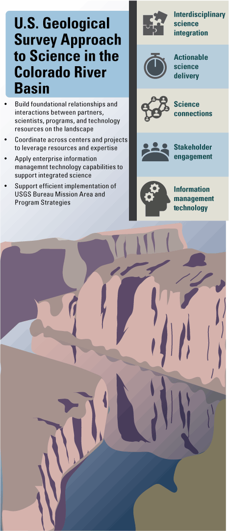
U.S. Geological Survey approach to advance interdisciplinary drought science.
Water as an Integrated System - Sources, Sinks, and Storage
On the second day of the Science Exchange, several presentations focused on the integrated water system and its sources, sinks, and storage. Scientists at the USGS Colorado Water Science Center presented a holistic assessment of Fountain Creek, Colorado, which included results from ecology, water quality, geomorphology, and surface-water studies. USGS Southwest Biological Science Center researchers presented information about the narrowing of the Green and Colorado Rivers through time and the effects of that change on aquatic habitats, as well as the development of a remote-sensing river vegetation monitoring system and accompanying web application to track trends in water use and habitat health. Scientists from the USGS Wyoming-Montana and Utah Water Science Centers shared the development of new snow models for water-resource forecasting (fig. 3). Presenters from the USGS Colorado Water Science Center introduced a methodology that uses tritium as a tracer to calculate base flow volume estimates, and researchers at the USGS New Mexico Water Science Center shared their work investigating sources of elevated nitrate in the groundwater of the Chihuahuan Desert. These complex water resource studies, which span groundwater, surface water, and snow, highlight the increasingly integrated nature of USGS science.
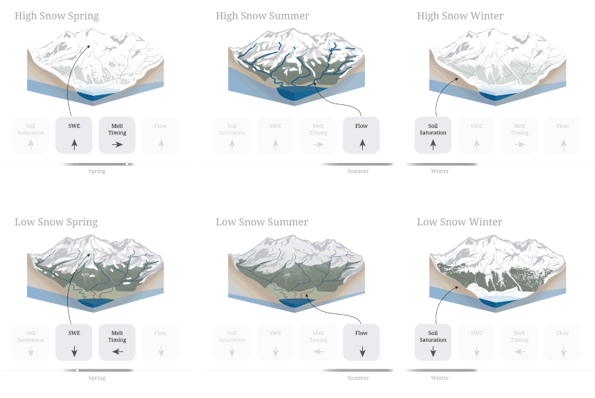
Snowmelt dynamics in a typical year (U.S. Geological Survey, 2022). Snow water equivalent (SWE) is a measure of the volume of water in snowpack.
Interdisciplinary Studies of Natural Hazards and Restoration
The broad range of processes that create natural hazards, and the effects of those hazards on ecosystems, further underscore the need for interdisciplinary science. The third day of the Science Exchange opened with a presentation about cascading hazards, with an example from the USGS Astrogeology Science Center of an asteroid impact. The scenario included short-term local effects, including blast winds, tsunamis, and forest fires, as well as longer-term, more widespread effects, including flooding, water pollution, and crop failure (fig. 4). Addressing such a complex scenario of interwoven hazards requires expertise from a wide range of scientists, including planetary scientists, geologists, climate scientists, and wildlife ecologists as well as civil defense and emergency response teams. The ensuing presentations in this session from the USGS Fort Collins Science Center, the Colorado Water Science Center, and the Forest and Rangeland Ecosystem Science Center described the effects of wildfires on lake water quality and ecosystems, optimizing conservation and restoration of sagebrush ecosystems, and restoring sagebrush habitats occupied by invasive grasses that exacerbate wildfires.
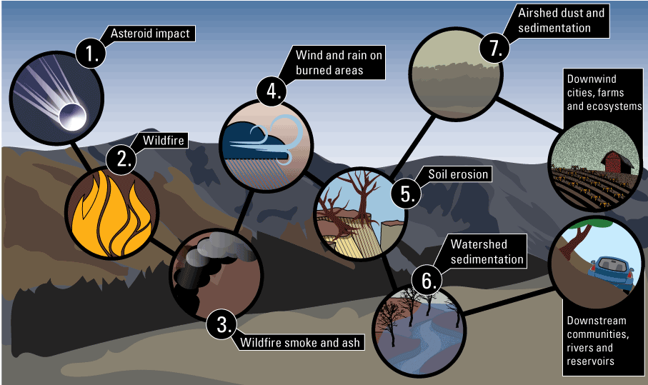
Cascading hazards can evolve from a single event such as an asteroid impact (adapted from Titus and others, 2023).
Emerging Methodology and Approaches to Interdisciplinary Science
The final session of the Science Exchange featured presentations that highlighted new and emerging methodologies that can be used to better address complex and interdisciplinary science problems. Multiple presentations described emerging uses of remote-sensing data in USGS science. At the USGS Southwest Biological Science Center, geomorphologists, planetary scientists, and remote-sensing experts are working to estimate sediment budgets on Mars by adapting methodologies used in the Colorado River Basin and Grand Canyon. At the USGS Colorado Water Science Center, scientists are developing new snow and streamflow monitoring and modeling techniques by combining noncontact streamflow monitors and on-the-ground measurements with uncrewed aircraft system-based light detection and ranging (lidar), radar, and photogrammetry and airborne snow observatories.
Other presentations in this session focused on new methodologies for improving environmental monitoring and citizens’ use of public lands. Scientists at the USGS Fort Collins Science Center are developing environmental DNA (eDNA, an approach to collect and extract genetic material from a variety of organisms present in environmental samples including sediment, soil, water, and air) indicator scores to replace more time-consuming methods for monitoring the presence of endangered and invasive fish species and their exposure to toxins. Another ongoing project at the Fort Collins Science Center, the Values Mapping for Planning in Regional Ecosystems, or VaMPiRE, project highlights the coproduction model of science by working with stakeholders to develop a public participatory geographic information system (GIS) tool via an interactive web mapping survey. This project will support Bureau of Land Management decision-makers by enabling them to take public land-use goals into account.
Outcomes of the Science Exchange
The USGS Rocky Mountain Region 2022 Science Exchange provided a platform for USGS scientists to inform others about recent and ongoing interdisciplinary science projects and stakeholder engagement and to make connections for future collaborations. Presentations related to water science, cascading hazards, land management, and emerging methodologies demonstrated the success of interdisciplinary research teams in the USGS and the desire to incorporate this type of science into USGS funding and management structures. In addition to scientific updates, the Science Exchange highlighted ways that the USGS has improved interdisciplinary research, stakeholder engagement, and coproduced science over the past several years by the growing use of online collaborative tools such as virtual meetings and file-sharing software, as well as virtual public lectures and events.
References
Titus, T., Robertson, D., Sankey, J., Mastin, L., and Rengers, F., 2023, A review of common natural disasters as analogs for asteroid impact effects and cascading hazards: Natural Hazards, p. 1-48, accessed February, 2023 at https://link.springer.com/article/10.1007/s11069-022-05722-z
U.S. Geological Survey, 2022, From snow to flow, what changing snowmelt means for water in the western U.S.: U.S. Geological Survey web page, accessed on July 21, 2022, at https://labs.waterdata.usgs.gov/visualizations/snow-to-flow/index.html#/.
For More Information
Region 7: Upper Colorado Basin https://go.usa.gov/xFFqY
Disclaimers
Any use of trade, firm, or product names is for descriptive purposes only and does not imply endorsement by the U.S. Government.
Although this information product, for the most part, is in the public domain, it also may contain copyrighted materials as noted in the text. Permission to reproduce copyrighted items must be secured from the copyright owner.
Suggested Citation
Peterson, D.E., French, K.L., Oden, J.H., Anderson, P.J., Titus, T.N., Dahm, K.G., Driscoll, J., Andrews, W.J., 2022, U.S. Geological Survey Rocky Mountain Region 2022 Science Exchange, Showcasing Interdisciplinary and State-of-the-Art USGS Science, U.S. Geological Survey Fact Sheet 2023-3017, 6 p., https://doi.org/10.3133/fs20233017.
ISSN: 2327-6932 (online)
| Publication type | Report |
|---|---|
| Publication Subtype | USGS Numbered Series |
| Title | U.S. Geological Survey Rocky Mountain Region 2022 science exchange, showcasing interdisciplinary and state-of-the-art USGS science |
| Series title | Fact Sheet |
| Series number | 2023-3017 |
| DOI | 10.3133/fs20233017 |
| Publication Date | June 28, 2023 |
| Year Published | 2023 |
| Language | English |
| Publisher | U.S. Geological Survey |
| Publisher location | Reston, VA |
| Contributing office(s) | Astrogeology Science Center, Central Energy Resources Science Center, Colorado Water Science Center, Fort Collins Science Center, Mineral Resources Program, Rocky Mountain Geographic Science Center, Geology, Geophysics, and Geochemistry Science Center |
| Description | 6 p. |
| Online Only (Y/N) | Y |